Karnagarh
Karnagarh (also written as Karnagar) is a village and a gram panchayat in the Salboni CD block in the Medinipur Sadar subdivision of the Paschim Medinipur district in the state of West Bengal, India.
Karnagarh | |
|---|---|
Village | |
 Karnagarh Location in West Bengal, India  Karnagarh Karnagarh (India) | |
| Coordinates: 22.5147°N 87.3536°E | |
| Country | |
| State | West Bengal |
| District | Paschim Medinipur |
| Population (2011) | |
| • Total | 2,812 |
| Languages* | |
| • Official | Bengali, Santali, English |
| Time zone | UTC+5:30 (IST) |
| PIN | 721129 |
| Telephone/STD code | 03222 |
| Lok Sabha constituency | Medinipur |
| Vidhan Sabha constituency | Medinipur |
| Website | paschimmedinipur |
History
According to Binoy Ghosh, the kings of Karnagarh ruled over a zamindari that included Midnapore and the surrounding areas. The dynasty that ruled over Karnagarh included Raja Lakshman Singh (1568-1661), Raja Shyam Singh (1661-1668), Raja Chhotu Roy (1668), Raja Raghunath Roy (1671-1693), Raja Ram Singh (1693-1711), Raja Jaswant Singh (1711-1749), Raja Ajit Singh (1749) and Rani Shiromani (1756-1812). The kings of Karnagarh belonged to the Sadgop community and had a close link with the rulers of Narajole. The last king of Karnagarh, Raja Ajit Singh died childless. His property went into the hands of his two queens, Rani Bhabani and Rani Shiromani. During the Chuar rebellion, the leader of the Chuars, Gobardhan Dikpati, occupied the palace. Both the queens met the king of Narajole, Raja Trilochan Khan. The latter provided them shelter and promised to recover their property. Rani Bhabani died in 1161 Bangabda (1754 AD) and Rani Shiromani handed over the entire property to Anandalal of the Narajole family even before she died in 1219 Bangabda (1812 AD). However, it must be noted that the British rulers were suspicious that Rani Shiromani had links with those involved in the Chuar Rebellion and for that she had to suffer considerably at their hands.[1]
There, however, are other sources that say that the Chuar Rebellion took place as a series of insurrections by people who lived off the jungles and a sort of primitive agriculture in the old Manbhum, Bankura and Midnapore districts between 1771 and 1809, generally under dispossessed zamindars that included Rani Shiromani of Karnagarh.[2][3]
Geography
| Cities and towns in Medinpur Sadar subdivision of Paschim Medinipur district M: municipal city/ town, CT: census town, R: rural/ urban centre, H: historical/ religious centre, F: facilities Owing to space constraints in the small map, the actual locations in a larger map may vary slightly |
Location
Karnagarh is located at 22.5147°N 87.3536°E.
Area overview
Paschim Medinipur district (before separation of Jhargram) had a total forest area of 1,700 km2, accounting for 14.31% of the total forested area of the state. It is obvious from the map of the Midnapore Sadar subdivision, placed alongside, is that there are large stretches of forests in the subdivision. The soil is predominantly lateritic.[4] Around 30% of the population of the district resides in this subdivision. 13.95% of the population lives in urban areas and 86.05% lives in the rural areas.[5]
Note: The map alongside presents some of the notable locations in the subdivision. All places marked in the map are linked in the larger full screen map.
Demographics
According to the 2011 Census of India, Karnagar had a total population of 2,812, of which 1,392 (50%) were males and 1,420 (50%) were females. There were 387 persons in the age range of 0–6 years. The total number of literate persons in Karnagar was 1,257 (51.84% of the population over 6 years).[6]
.*For language details see Salboni (community development block)#Language and religion
Karnagarh fort
Karnagarh fort consisted of about 100 bighas of land, stretching for about 4 miles, that was surrounded by the Parang River. It was about 4 miles north of Midnapore. The inside of the fort was divided into two parts, the andar mahal for the royal family and the sadar mahal for others. The temples of Dandesvara and Mahamaya, the ruling deities of Karnagarh, were located to the south of the fort. Now, hardly anything, other than memory, remains.[1] The Karnagarh family had two other forts nearby – at Abasgarh and Jamdargarh.[1]
Culture
David J. McCutchion mentions the Dandesvara temple as having a pirha larger than the main temple, measuring 13’ 6” square + 25’ square, built of laterite having stucco decoration.[7]
The 60’ high Anadilinga Dandesvara and the Devi Bhagabati Mahamaya temples are the main attractions at Karnagarh. Both these temples were built by Karna Keshari of the Keshari/ Somavamsi dynasty of Odisha in the 10th century. A big fair is held on the Poush Sankranti day (mid-January).[8]
“Both temples have been painted pink and the magic of black stone is lost. However, the surrounding walls are still in black and the ambience magical.” [3]
Both the Dandesvara and Mahamaya temples are state protected monuments.[9]
Karnagarh picture gallery
_and_Devi_Bhagavati_Mahamaya_Temple_at_Karnagarh_at_Paschim_Medinipur_district_In_West_Bengal_01.jpg.webp) Dandesvara and Mahamaya temples
Dandesvara and Mahamaya temples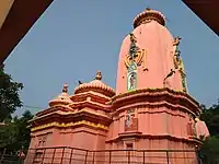 Dandesvara temple
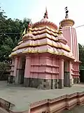 Mahamaya temple
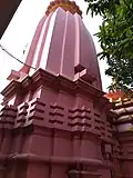 Jogmaya temple
The pictures are a part of Wiki Explores Paschim Medinipur programme, an initiative by West Bengal Wikimedians User Group
References
- Ghosh, Binoy, Paschim Banger Sanskriti, (in Bengali), part II, 1976 edition, pages 86-90, Prakash Bhaban, Kolkata.
- Sengupta, Nitish, History of the Bengali-Speaking People, UBS Publishers’ Distributors Pvt. Ltd., 2001. Pages 187-188. ISBN 81-7476-355-4
- "Next weekend you can be at Karnagarh". The Telegraph, 6 July 2008. Retrieved 22 August 2020.
- "District Human Development Report Paschim Medinipur, 2011". page 7, 27. Department of Planning and Statistics, Government of West Bengal. Retrieved 10 September 2020.
- "District Statistical Handbook Paschim Medinipur, 2013". Table 2.2, 2.4 (a). Department of Planning and Statistics. Retrieved 10 September 2020.
- "CD block Wise Primary Census Abstract Data(PCA)". West Bengal – District-wise CD blocks. Registrar General and Census, India. Retrieved 21 August 2020.
- McCutchion, David J., Late Mediaeval Temples of Bengal, first published 1972, reprinted 2017, page 69 n. The Asiatic Society, Kolkata, ISBN 978-93-81574-65-2
- "Attractions of Paschim Medinipur". Karnagarh. Department of Tourism, Government of West Bengal. Retrieved 22 August 2020.
- List of State Protected Monuments as reported by the Archaeological Survey of India Archived 2013-05-23 at the Wayback Machine.
External links
| Wikimedia Commons has media related to Karnagarh. |
Cities, towns and locations in Paschim Medinipur District | |||||||
|---|---|---|---|---|---|---|---|
| Cities, municipal and census towns |
| ||||||
| Locations other than cities and towns | |||||||
| Related topics |
| ||||||