Mankar
Mankar is a village in Galsi I CD Block in Bardhaman Sadar North subdivision of Purba Bardhaman district in the state of West Bengal, India.
Mankar | |
|---|---|
Village | |
 Mankar Location in West Bengal, India  Mankar Mankar (India) | |
| Coordinates: 23.435319°N 87.55273°E | |
| Country | |
| State | West Bengal |
| District | Purba Bardhaman |
| Population (2011) | |
| • Total | 10,370 |
| Languages | |
| • Official | Bengali, English |
| Time zone | UTC+5:30 (IST) |
| PIN | 713144 (Mankar) |
| Telephone/STD code | 03452 |
| Lok Sabha constituency | Bardhaman-Durgapur |
| Vidhan Sabha constituency | Galsi |
| Website | purbabardhaman |
Mythology
It is said that the Pandavas lived in hiding at Mankar during their agyatbasa. There is a very old temple with idols of the Pandavas.[1]
Geography
| Cities and towns in the Bardhaman Sadar North subdivision of Purba Bardhaman district M: municipal city/ town, CT: census town, R: rural/ urban centre, H: historical site, W: river project, C: craft centre Owing to space constraints in the small map, the actual locations in a larger map may vary slightly |
Location
Mankar is located at 23.435319°N 87.55273°E.
Urbanisation
73.58% of the population of Bardhaman Sadar North subdivision live in the rural areas. Only 26.42% of the population live in the urban areas, and that is the highest proportion of urban population amongst the four subdivisions in Purba Bardhaman district.[2] The map alongside presents some of the notable locations in the subdivision. All places marked in the map are linked in the larger full screen map.
Demographics
As per the 2011 Census of India Mankar had a total population of 10,370, of which 5,290 (51%) were males and 5,080 (49%) were females. Population below 6 years was 1,088. The total number of literates in Mankar was 6,981 (75.21% of the population over 6 years).[3]
Transport
Mankar is a station on the Bardhaman-Asansol section, which is a part of Howrah-Gaya-Delhi line, Howrah-Allahabad-Mumbai line and Howrah-Delhi main line.[4]
State Highway 14 running from Dubrajpur (in Birbhum district) to Betai (in Nadia district) passes through Mankar.[5]
Education
Kanad Institute of Engineering and Management was established at Mankar in 2008. It is affiliated with Maulana Abul Kalam Azad University of Technology.[6]
Mankar College at Mankar was established in 1987. It is affiliated with Kazi Nazrul University (K.N.U.). It offers honours courses in Bengali, Hindi, Sanskrit, English, history, geography, political science, philosophy, accountancy, computer science and mathematics.[7]
Mankar High School, a boys only high school, and Mankar Girls’ High School, a girls only high school, are affiliated with the West Board of Secondary Education.[8] Mankar High School, a co-educational higher secondary unit, is affiliated with West Bengal Council of Higher Secondary Education for higher secondary classes.[9] Mankar High School was established in 1855.[10] Mankar Girls High School was established in 1957.[11]
Culture
David J. McCutchion focuses on several temples at Mankar:[12]
- Deuleswara Shiva temple at Raypur, with rich terracotta façade
- Shiva temple at Bhattacharjeepara with rich terracotta on four sides
- Shiva temple of Dutta family at Raypara having façade fully decorated with terracotta figures
- Lakshmi Janardana temple of Kar family – a plain brick structure
- The unfinished octagonal ridged rekha deul of Biswas family
- Temple with octagonal duplicated chala, equivalent to an atchala
- Domed octagonal Radha Ballav temple with a veranda
- Pancharatna dolmancha
Mankar picture gallery
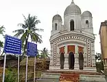 Lakshmi Janardan temple of Morol family
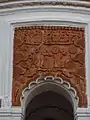 Central arch panel of Morol family temple
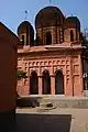 Lakshmi Janardan temple of Kar family
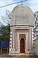 Shiva temple of Banerjee family
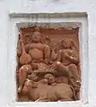 Terracotta wall decoration of Shiva and Parvati in the Banerjee family temple
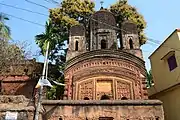 Shiva temple of Dutta family
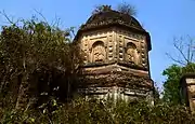 Ruined Radha Ballav temple
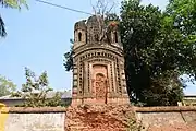 Pancha-ratna Dol Mancha
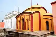 Anandamoyee temple complex
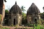 Chala temples in the ruined Rang Mahal complex
The pictures are a part of Wiki Explores Purba Bardhaman programme, an initiative by West Bengal Wikimedians User Group
Healthcare
Mankar Rural Hospital at Mankar (with 30 beds) and Pursha Rural Hospital at Pursha (with 30 beds) are the main medical facilities in Galsi I CD block. There are primary health centres at: Bharatpur (with 6 beds) and Lowa, PO Dwarmari (with 10 beds).[13]
See also - Healthcare in West Bengal
References
- "Purba Bardhaman district". Tourism. District authorities. Retrieved 15 February 2019.
- "District Statistical Handbook 2014 Bardhaman". Table 2.2. Department of Statistics and Programme Implementation, Government of West Bengal. Archived from the original on 21 January 2019. Retrieved 25 January 2019.
- "2011 Census – Primary Census Abstract Data Tables". West Bengal – District-wise. Registrar General and Census Commissioner, India. Retrieved 16 March 2017.
- "63509 Bardhaman-Asansol MEMU". Time Table. indiarailinfo. Retrieved 9 February 2017.
- "List of State Highways in West Bengal". West Bengal Traffic Police. Retrieved 5 February 2017.
- "Kanad Institute of Engineering and Management". KIEM. Retrieved 2 March 2017.
- "Mankar College". College Admission. Retrieved 2 March 2017.
- "West Bengal Board of Secondary Education". Burdwan. WBBSE. Retrieved 29 January 2019.
- "West Bengal Council of Higher Secondary Education". Budwan. WBCHSE. Retrieved 29 January 2019.
- "Mankar High School". Schools World.in. Retrieved 23 January 2019.
- "Mankar Girls' High School". ICBSE. Retrieved 23 January 2019.
- McCutchion, David J., Late Mediaeval Temples of Bengal, first published 1972, reprinted 2017, pages 23, 46, 50, 59, 60, 61, 75. The Asiatic Society, Kolkata, ISBN 978-93-81574-65-2
- "Health & Family Welfare Department". Health Statistics. Government of West Bengal. Retrieved 19 January 2019.
External links
| Wikimedia Commons has media related to Mankar. |
Cities, towns and locations in Purba Bardhaman district, West Bengal | |||||||||
|---|---|---|---|---|---|---|---|---|---|
| Cities, municipal and census towns |
| ||||||||
| Locations other than cities and towns |
| ||||||||
| Related topics |
| ||||||||