Shaulan
Shaulan (also spelled Saulan) is a village in the Daspur I CD block in the Ghatal subdivision of the Paschim Medinipur district in the state of West Bengal, India.
Shaulan | |
|---|---|
Village | |
 Shaulan Location in West Bengal, India  Shaulan Shaulan (India) | |
| Coordinates: 22.5423°N 87.7046°E | |
| Country | |
| State | West Bengal |
| District | Paschim Medinipur |
| Population (2011) | |
| • Total | 867 |
| Languages | |
| • Official | Bengali, English |
| Time zone | UTC+5:30 (IST) |
| PIN | 721211 |
| Telephone/STD code | 03225 |
| Lok Sabha constituency | Ghatal |
| Vidhan Sabha constituency | Daspur |
| Website | paschimmedinipur |
Geography
Shaulan is located at 22.5423°N 87.7046°E.
Demographics
According to the 2011 Census of India, Shaulan had a total population of 964, of which 469 (49%) were males and 495 (51%) were females. There were 117 persons in the age range of 0–6 years. The total number of literate persons in Shaulan was 702 (82.88% of the population over 6 years).[1]
Culture
David J. McCutchion mentions the Shyama Sundara temple as a standard West Bengal type pancha-ratna having figures in the archway panels and round the facade. Built in the 19th century, it measures 17’ 10” square.[2]
Shaulan picture gallery
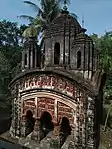 Shyama Sundara pancha-ratna temple constructed by the Adhikari family
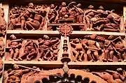 Terracotta panels
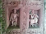 Decorated wooden doorway
The pictures are a part of Wiki Explores Paschim Medinipur programme, an initiative by West Bengal Wikimedians User Group
References
- "CD block Wise Primary Census Abstract Data(PCA)". West Bengal – District-wise CD blocks. Registrar General and Census, India. Retrieved 21 August 2020.
- McCutchion, David J., Late Mediaeval Temples of Bengal, first published 1972, reprinted 2017, page 47. The Asiatic Society, Kolkata, ISBN 978-93-81574-65-2
External links
| Wikimedia Commons has media related to Saulan, Daspur I CD block. |
Cities, towns and locations in Paschim Medinipur District | |||||||
|---|---|---|---|---|---|---|---|
| Cities, municipal and census towns |
| ||||||
| Locations other than cities and towns | |||||||
| Related topics |
| ||||||
