Al-Arroub (camp)
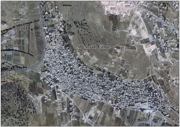
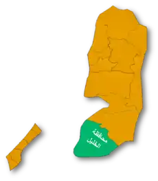
al-Arroub (Arabic: مخيّم العروب, lit. 'Camp al-'Arrub') is a Palestinian refugee camp located in the southern West Bank along the Hebron-Jerusalem road in the Hebron Governorate. al-Arroub is 15 kilometers south of Bethlehem, with a total land area of 240 dunums.
al-Arroub Camp | |
|---|---|
| Arabic transcription(s) | |
| • Arabic | مخيّم العروبة |
| • Latin | al-'Arrub (official) al-Aroub (unofficial) |
.jpg.webp) Palestinian demonstrators against occupation in El-Arrub | |
 al-Arroub Camp Location of al-Arroub Camp within Palestine 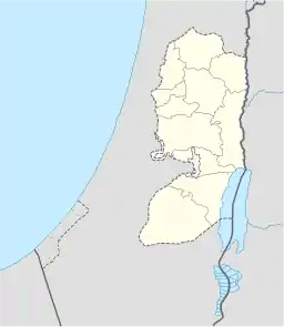 al-Arroub Camp al-Arroub Camp (the West Bank) | |
| Coordinates: 31°37′23.18″N 35°08′12.19″E | |
| State | State of Palestine |
| Governorate | Hebron |
| Government | |
| • Type | Refugee Camp (from 1950) |
| Area | |
| • Total | 240 dunams (0.24 km2 or 0.09 sq mi) |
| Population (2016) | |
| • Total | 10,487 |
| • Density | 44,000/km2 (110,000/sq mi) |
Since the Six-Day War in 1967, the camp has been under Israeli occupation. The population in the 1967 census conducted by the Israeli authorities was 3,647.[1]
According to the UNRWA, in 2005, it had a population of 9,859 registered refugees.[2] According to the Palestinian Central Bureau of Statistics (PCBS), the camp's population is 10,487 in 2016.[3]
In 2002, two schools were built in the camp: the Arroup Secondary School for boys, and another school for girls.[2]
Arroup Secondary School
Arroup Secondary School is a boys' secondary school in the Al-Arroub refugee camp in Hebron Governorate. A school was rented in the Arroup refugee camp lands, on the top of a mountain to remark the first secondary school for boys in the camp. This school is basically a floor rented house, because suppliers didn't have the funds to build a new school for students.
References
- Perlmann, Joel (November 2011 – February 2012). "The 1967 Census of the West Bank and Gaza Strip: A Digitized Version" (PDF). Levy Economics Institute. Retrieved 24 June 2016.
- Arroub Refugee Camp United Nations Relief and Works Agency for Palestine Refugees in the Near East (UNRWA)
- 'Localities in Hebron Governorate by Type of Locality and Population Estimates, 2007-2016 ,' Palestinian Central Bureau of Statistics, 2016.
External links
- Welcome To al-'Arrub Refugee Camp
- Al 'Arrub Refugee Camp (Fact Sheet), Applied Research Institute–Jerusalem (ARIJ)
- Al 'Arrub Refugee Camp Profile, ARIJ
- Al 'Arrub Refugee Camp aerial photo, ARIJ
- The priorities and needs for development in Al 'Arrub camp based on the community and local authorities’ assessment, ARIJ
- Arroub refugee camp, UNWRA
| Cities |
|  |
|---|---|---|
| Towns |
| |
| Villages |
| |
| Refugee camps | ||
Palestine refugee camps locations and populations as of 2015[1] | ||||||||||||||||||||||||||||||||||||||||||||||||||||||||||||||||||||||||||||||||||||||||||||||||||||||||||||||||||||||||||||||||||||||||||||||||||||
|---|---|---|---|---|---|---|---|---|---|---|---|---|---|---|---|---|---|---|---|---|---|---|---|---|---|---|---|---|---|---|---|---|---|---|---|---|---|---|---|---|---|---|---|---|---|---|---|---|---|---|---|---|---|---|---|---|---|---|---|---|---|---|---|---|---|---|---|---|---|---|---|---|---|---|---|---|---|---|---|---|---|---|---|---|---|---|---|---|---|---|---|---|---|---|---|---|---|---|---|---|---|---|---|---|---|---|---|---|---|---|---|---|---|---|---|---|---|---|---|---|---|---|---|---|---|---|---|---|---|---|---|---|---|---|---|---|---|---|---|---|---|---|---|---|---|---|---|---|
| ||||||||||||||||||||||||||||||||||||||||||||||||||||||||||||||||||||||||||||||||||||||||||||||||||||||||||||||||||||||||||||||||||||||||||||||||||||
References
| ||||||||||||||||||||||||||||||||||||||||||||||||||||||||||||||||||||||||||||||||||||||||||||||||||||||||||||||||||||||||||||||||||||||||||||||||||||