as-Samu
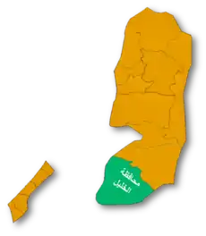
As Samu' or es-Samu' (Arabic: السموع) (![]() pronunciation ) is a town in the Hebron Governorate of the West Bank, Palestine, 12 kilometers south of the city of Hebron and 60 kilometers southwest of Jerusalem.
pronunciation ) is a town in the Hebron Governorate of the West Bank, Palestine, 12 kilometers south of the city of Hebron and 60 kilometers southwest of Jerusalem.
As Samu' | |
|---|---|
| Arabic transcription(s) | |
| • Arabic | السموع |
| • Latin | es Samu' (official) Samua (unofficial) |
.jpg.webp) As-Samu, 2007 | |
 As Samu' Location of As Samu' within Palestine | |
| Coordinates: 31°24′03″N 35°04′02″E | |
| Palestine grid | 156/89 |
| State | State of Palestine |
| Governorate | Hebron |
| Government | |
| • Type | Municipality |
| • Head of Municipality | abed ennabe elhawamde |
| Area | |
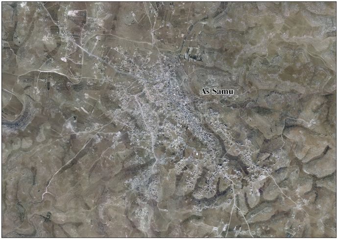
| • Total | 13,800 dunams (13.8 km2 or 5.3 sq mi) |
| Population (2007) | |
| • Total | 19,649 |
| • Density | 1,400/km2 (3,700/sq mi) |
| Name meaning | Es Semua (p.n.)[1] |
Geography
The area is a hilly, rocky area cut by some wadis. The Armistice Demarcation Line (ADL, Green line) runs generally east to west approximately five kilometers south of as Samu. The village of as Samu is located on twin hills with a wadi varying from shallow to deep between them.[2] According to the Palestinian Central Bureau of Statistics the town had a population of 19,649 in 2007.[3]
History
Roman and Byzantine period
During the Biblical,[4] Roman and Byzantine period, Eshtemoa, believed to be as-Samu, was described by Eusebius in his Onomasticon as a large Jewish village.[5][6]
The Jerusalem Talmud mentions Eshtemoa as the place of residence of an amora (scholar) who dwelt in the town during the 4th century by the name of Hasa of Eshtemoa.[7]
Middle Ages
What was earlier identified to be part of a 12th-century Crusaders tower, turned out to be a 4th-century synagogue, which was turned into a mosque at the time of Saladin, according to tradition.[8][9]
Ottoman era
As-Samu, was incorporated into the Ottoman Empire in 1517, and in the census of 1596 the village appeared as being in the Nahiya of Halil of the Liwa of Quds. It had a population of 16 households, all Muslim. They paid a fixed tax-rate of 33,3% on agricultural products, including wheat, barley, vineyards and fruit trees, in addition to occasional revenues, goats and bee-hives; a total of 3000 akçe.[10]
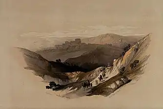
In 1838, Edward Robinson identified the town of Semua with biblical Eshtemoa.[11] He described As-Samu as a "considerable" village..."full of flocks and herds all in fine order". He also found remains of walls built from very large stones, some of which were more than 10 feet long.[12] In 1863 the French explorer Victor Guérin visited the place.[13]
An Ottoman village list from about 1870 found that as-Samu had a population of 298, in 77 houses, though the population count included men, only.[14][15]
In 1883, the Palestine Exploration Fund's Survey of Western Palestine described it as "A village of moderate size, standing high. On the north is an open valley, and the modern buildings extend along a spur which runs out west from the watershed. The ground is rocky on the hills, but the valleys are arable land. There are remains of an ancient castle in the village, and other fragments. A church is said once to have existed here, and the ruins to the west show that the town was once much larger. To the south there are olives in the valley. To the north there are rock-cut tombs on the hill-side ; the water-supply is from cisterns. The inhabitants number some 400 to 500 souls.[16]
British Mandate era
In the 1922 census of Palestine conducted by the British Mandate authorities, As-Samu (called: AI Samu) had an entirely Muslim population of 1,600 inhabitants.[17] In the 1931 census, As-Samu, together with Khirbat al-Simia and Kh. Rafat had a total of 1,882 Muslims, in 372 houses.[18] In 1934, remains of the towns ancient synagogue were discovered and the site was later excavated in 1969, by Ze'ev Yeivin.[19]
In the 1945 statistics the population of As-Samu was 2,520, all Muslims,[20] who owned 138,872 dunams of land according to an official land and population survey.[21] 30 dunams were plantations and irrigable land, 40,398 for cereals,[22] while 165 dunams were built-up (urban) land.[23]
Jordanian era
In the wake of the 1948 Arab–Israeli War and the 1949 Armistice Agreements, As-Samu was annexed by Jordan along with the rest of the renamed ‘West Bank’.
In 1961, the population of Samu was 3,103.[24]
In 1966 Israel launched a full-scale military operation against the town, which resulted in the deaths of fifteen Jordanian soldiers and three Jordanian civilians; fifty-four other soldiers were wounded. The villagers suffered 3 civilians killed and 96 wounded. According to David Dean Shulman, the villagers were unconnected to the incident that had triggered the reprisal. Much of the village was destroyed.[25] The commander of the Israeli paratroop battalion, Colonel Yoav Shaham, was killed and ten other Israeli soldiers were wounded.
Israeli occupation
As a result of the Six-Day War in 1967, As-Samu came under Israeli occupation. The population in the 1967 census conducted by the Israeli authorities was 3,784.[26] Under the Oslo Accords, the town was assigned to Area A.[27]
It was reported in 2005 that 10,000 dunums of land in the towns of As Samu, Yatta and ad-Dhahiriya near Hebron were to be seized by the Israel Defense Forces for the construction of the separation wall.[28] Palestinian sources have alleged that settler violence from the nearby Israeli settlements of Ma'on and Asa'el has prevented them from accessing their fields.[29][30]
Culture
A headdress or 'money hat' (wuqayat al-darahem) from as-Samu (c. 1840s, with later additions) is exhibited at the British Museum. The caption notes that the headdress was worn in the 19th century and early 20th century during the wedding ceremony, especially for the 'going out to the well' ceremony when the bride appeared in public as a married woman for the first time.[31] Generally, the headdress was considered to be one of the most important parts of the Palestinian costume.
See also
References
- Palmer, 1881, p. 433
- UN Doc
- 2007 PCBS Census Archived December 10, 2010, at the Wayback Machine Palestinian Central Bureau of Statistics. p.121.
- Joshua 15:50
- Avraham Negev; Shimon Gibson (July 2005). Archaeological encyclopedia of the Holy Land. Continuum International Publishing Group. pp. 167–168. ISBN 978-0-8264-8571-7. Retrieved 29 September 2010.
- Eusebius, Onomasticon - The Place Names of Divine Scripture, (ed.) R. Steven Notley & Ze'ev Safrai, Brill: Leiden 2005, p. 84 (§429), note 429 ISBN 0-391-04217-3
- Ben-Zion Rosenfeld (2009). Torah Centers and Rabbinic Activity in Palestine 70-400 C.e: History and Geographic Distribution. BRILL. p. 81. ISBN 978-90-04-17838-0. Retrieved 12 June 2011.
- Conder and Kitchener, 1883, SWP III, pp. 412-413
- Pringle, 1997, p. 118
- Hütteroth and Abdulfattah, 1977, p. 123
- Robinson and Smith, 1841, vol 2, p. 194
- Robinson and Smith, 1841, vol 2, pp. 626-7
- Guérin, 1869, pp. 173 -176, 196
- Socin, 1879, p. 154
- Hartmann, 1883, p. 142, also noted 77 houses
- Conder and Kitchener, 1883, SWP III, p. 403
- Barron, 1923, Table V, p. 10
- Mills, 1932, p. 33
- על מקור תוכניותיהם של בתי-הכנסת בדרום הר-יהודה [Sources for the Plans of the Synagogues in Southern Mount Hebron] (in Hebrew). Snunit.k12.il. Retrieved 2010-07-06.
- Government of Palestine, Department of Statistics, 1945, p. 23
- Government of Palestine, Department of Statistics. Village Statistics, April, 1945. Quoted in Hadawi, 1970, p. 50 Archived 2011-06-04 at the Wayback Machine
- Government of Palestine, Department of Statistics. Village Statistics, April, 1945. Quoted in Hadawi, 1970, p. 94
- Government of Palestine, Department of Statistics. Village Statistics, April, 1945. Quoted in Hadawi, 1970, p. 144
- Government of Jordan, Department of Statistics, 1964, p. 14
- David Dean Shulman, 'On Being Unfree:Fences, Roadblocks and the Iron Cage of Palestine,' Manoa Vol,20, No. 2, 2008, pp. 13-32
- Perlmann, Joel (November 2011 – February 2012). "The 1967 Census of the West Bank and Gaza Strip: A Digitized Version" (PDF). Levy Economics Institute. Retrieved 24 June 2016.
- B'Tselem Interactive Map https://www.btselem.org/map
- UN Doc Chronological Review of Events Relating to the Question of Palestine; Monthly Media Monitoring Review March 2005
- 14 May: Farmers and shepherds from Yatta and As Samu towns were denied access to their land by settlers from Ma'on settlement.
- Relief web. According to Palestinian sources, a 30-year-old Palestinian man from the town of As-Samu' sustained multiple bodily injuries when a group of settlers beat him and dragged him to the nearby settlement outpost of Asael. The settlers then tied him to an electricity pole where the assault continued.
- Money hat
- Samou'a Kilims, by Hamdan Taha
Bibliography
- Barron, J.B., ed. (1923). Palestine: Report and General Abstracts of the Census of 1922. Government of Palestine.
- Ben-Yehûdā, Ḥ. and Sandler, Shmuel (2002). The Arab-Israeli Conflict Transformed: Fifty Years of Interstate and Ethnic Crises. SUNY Press. ISBN 0-7914-5245-X
- Bowen, J. (2003). Six Days: How the 1967 War Shaped the Middle East. London: Simon & Schuster. ISBN 0-7432-3095-7.
- Chen, S.: The Design of the Ancient Synagogues in Judaea: Eshtemoa and Horvat Susiya
- Conder, C.R.; Kitchener, H.H. (1883). The Survey of Western Palestine: Memoirs of the Topography, Orography, Hydrography, and Archaeology. 3. London: Committee of the Palestine Exploration Fund.
- Dauphin, Claudine (1998). La Palestine byzantine, Peuplement et Populations. BAR International Series 726 (in French). III : Catalogue. Oxford: Archeopress. ISBN 0-860549-05-4. (p. 972)
- Government of Jordan, Department of Statistics (1964). First Census of Population and Housing. Volume I: Final Tables; General Characteristics of the Population (PDF).
- Government of Palestine, Department of Statistics (1945). Village Statistics, April, 1945.
- Guérin, V. (1869). Description Géographique Historique et Archéologique de la Palestine (in French). 1: Judee, pt. 3. Paris: L'Imprimerie Nationale.
- Hadawi, S. (1970). Village Statistics of 1945: A Classification of Land and Area ownership in Palestine. Palestine Liberation Organization Research Center. Archived from the original on 2018-12-08. Retrieved 2014-06-27.
- Hartmann, M. (1883). "Die Ortschaftenliste des Liwa Jerusalem in dem türkischen Staatskalender für Syrien auf das Jahr 1288 der Flucht (1871)". Zeitschrift des Deutschen Palästina-Vereins. 6: 102–149.
- Hütteroth, Wolf-Dieter; Abdulfattah, Kamal (1977). Historical Geography of Palestine, Transjordan and Southern Syria in the Late 16th Century. Erlanger Geographische Arbeiten, Sonderband 5. Erlangen, Germany: Vorstand der Fränkischen Geographischen Gesellschaft. ISBN 3-920405-41-2.
- Hussein of Jordan (1969). My "War" with Israel. London: Peter Owen. ISBN 0-7206-0310-2
- Mayhew, C.; Adams, M. (2006). Publish It Not: The Middle East Cover Up. Signal Books. ISBN 1-904955-19-3.
- Mills, E., ed. (1932). Census of Palestine 1931. Population of Villages, Towns and Administrative Areas. Jerusalem: Government of Palestine.
- Oren, M. (2002). Six Days of War. Oxford University Press. ISBN 0-19-515174-7
- Palmer, E.H. (1881). The Survey of Western Palestine: Arabic and English Name Lists Collected During the Survey by Lieutenants Conder and Kitchener, R. E. Transliterated and Explained by E.H. Palmer. Committee of the Palestine Exploration Fund.
- Pringle, Denys (1997). Secular buildings in the Crusader Kingdom of Jerusalem: an archaeological Gazetter. Cambridge University Press. ISBN 0521 46010 7.
- Prittie, Terence (1969). Eshkol of Israel: The Man and the Nation. London, Museum Press. ISBN 0-273-40475-X
- Robinson, E.; Smith, E. (1841). Biblical Researches in Palestine, Mount Sinai and Arabia Petraea: A Journal of Travels in the year 1838. 1. Boston: Crocker & Brewster. (p. 312)
- Robinson, E.; Smith, E. (1841). Biblical Researches in Palestine, Mount Sinai and Arabia Petraea: A Journal of Travels in the year 1838. 2. Boston: Crocker & Brewster.
- Socin, A. (1879). "Alphabetisches Verzeichniss von Ortschaften des Paschalik Jerusalem". Zeitschrift des Deutschen Palästina-Vereins. 2: 135–163.
External links
- Welcome To The City of al-Samu'
- Samu’a, Welcome to Palestine
- Survey of Western Palestine, Map 25: IAA, Wikimedia commons
- Samu’a, Ta'ayush
- As Samu' Town (Fact Sheet), Applied Research Institute–Jerusalem (ARIJ)
- As Samu' Town Profile, ARIJ
- As Samu' aerial photo, ARIJ
- The priorities and needs for development in As Samu' town based on the community and local authorities’ assessment, ARIJ
| Cities |
|  |
|---|---|---|
| Towns |
| |
| Villages |
| |
| Refugee camps | ||
