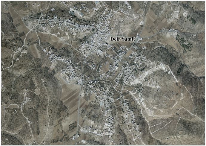
Deir Sammit
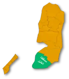
Deir Sammit (Arabic: دير سامت) is a Palestinian town located eight kilometers west of Hebron. The town is in the Hebron Governorate Southern West Bank. According to the Palestinian Central Bureau of Statistics, the town had a population of over 6,237 in 2007.[2]
Deir Sammit | |
|---|---|
| Arabic transcription(s) | |
| • Arabic | دير سامت |
 Deir Sammit Location of Deir Sammit within Palestine | |
| Coordinates: 31°31′22″N 34°58′27″E | |
| Palestine grid | 148/103 |
| State | State of Palestine |
| Governorate | Hebron |
| Government | |
| • Type | Municipality |
| Population (2007) | |
| • Total | 6,237 |
| Name meaning | Kh. Deir Sâmat, the ruin of the monastery of the silent man[1] |
History
In the early tax registers from the 1500s in the Ottoman Empire, Deir Sammit was noted as being cultivated[3] by the villagers of Suba.[4]
In 1838, it was noted as a place "in ruins or deserted," part of the area between Hebron and Gaza, but under the jurisdiction of Hebron.[5][6]
In 1863, Victor Guérin called the place Khirbet Deir Samit.[7]
In 1883, the PEF's Survey of Palestine noted "traces of ruins, caves, and cisterns" here.[8]
British Mandate era
At the time of the 1931 census of Palestine the population of Deir Samit was counted under Dura.[9]
Modern era
In the wake of the 1948 Arab–Israeli War, and after the 1949 Armistice Agreements, Deir Sammit came under Jordanian rule. The Jordanian census of 1961 found 808 inhabitants in Deir Sammit.[10]
After the Six-Day War in 1967, Deir Sammit has been under Israeli occupation.
Footnotes
- Palmer, 1881, p. 398
- 2007 PCBS Census Archived December 10, 2010, at the Wayback Machine Palestinian Central Bureau of Statistics. p.119.
- Toledano, 1984, p. 302. Toledano gives its location as 31°31′20″N 34°58′05″E
- Toledano, 1984, p. 282
- Robinson and Smith, 1841, vol 3, Appendix 2, p. 117
- Robinson and Smith, 1841, vol 3, p. 10
- Guérin, 1869, pp. 344-345: "...au milieu des débris d'une petite ville détruite, qui me sont indiqués sous le nom de Khirbet Deir Samit, [], ou peut-être Samith.
La place que cette ville occupait sur les pentes et sur le sommet d'une colline est maintenant couverte de nombreux amas de grosses pierres, soit taillées avec soin, soit presque brutes. Les citernes et les silos y abondent. Plusieurs excavations, qui paraissent être d'anciennes carrières, servent aujourd'hui de refuge aux bergers et à leurs troupeaux, pendant la mauvaise saison." - Conder and Kitchener, 1883, SWP III, p. 353
- Mills, 1932, p. 29
- Government of Jordan, Department of Statistics, 1964, p. 22
Bibliography
- Conder, C.R.; Kitchener, H.H. (1883). The Survey of Western Palestine: Memoirs of the Topography, Orography, Hydrography, and Archaeology. 3. London: Committee of the Palestine Exploration Fund.
- Government of Jordan, Department of Statistics (1964). First Census of Population and Housing. Volume I: Final Tables; General Characteristics of the Population (PDF).
- Guérin, V. (1869). Description Géographique Historique et Archéologique de la Palestine (in French). 1: Judee, pt. 2. Paris: L'Imprimerie Nationale.
- Mills, E., ed. (1932). Census of Palestine 1931. Population of Villages, Towns and Administrative Areas. Jerusalem: Government of Palestine.
- Palmer, E.H. (1881). The Survey of Western Palestine: Arabic and English Name Lists Collected During the Survey by Lieutenants Conder and Kitchener, R. E. Transliterated and Explained by E.H. Palmer. Committee of the Palestine Exploration Fund.
- Robinson, E.; Smith, E. (1841). Biblical Researches in Palestine, Mount Sinai and Arabia Petraea: A Journal of Travels in the year 1838. 3. Boston: Crocker & Brewster.
- Toledano, E. (1984). "The Sanjaq of Jerusalem in the Sixteenth Century: Aspects of Topography and Population". Archivum Ottomanicum. 9: 279–319.
External links
- Welcome to Dayr Samit
- Deir Samet, Welcome to Palestine
- Survey of Western Palestine, Map 21: IAA, Wikimedia commons
- Deir Samit Village (fact sheet), Applied Research Institute–Jerusalem (ARIJ)
- Deir Samit village profile, ARIJ
- Deir Samit aerial photo, ARIJ
- The priorities and needs for development in Deir Samit village based on the community and local authorities' assessment, ARIJ
- Constructing the Segregation Wall are in Deir Samit village – Hebron, September 23, 2004, POICA
| Cities |
|  |
|---|---|---|
| Towns |
| |
| Villages |
| |
| Refugee camps | ||