Allardville Parish, New Brunswick
Allardville is a civil parish in Gloucester County, New Brunswick, Canada.[2]
Allardville | |
|---|---|
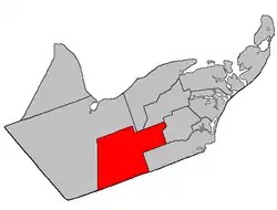 Location within Gloucester County, New Brunswick | |
| Coordinates: 47.48°N 65.5°W | |
| Country | |
| Province | |
| County | Gloucester |
| Erected | 1947 |
| Area | |
| • Land | 654.69 km2 (252.78 sq mi) |
| Population (2016)[1] | |
| • Total | 2,032 |
| • Density | 3.1/km2 (8/sq mi) |
| • Change 2011-2016 | |
| • Dwellings | 932 |
| Time zone | UTC-4 (AST) |
| • Summer (DST) | UTC-3 (ADT) |
For governance purposes it is divided between the local service districts of Allardville[lower-alpha 1] and Saint-Sauveur, both of which are members of the Chaleur Regional Service Commission (CRSC).[3]
Origin of name
The parish was named in honour of Monsignor Jean-Joseph-Auguste Allard, who oversaw its settlement.[4]
History
Allardville was erected in 1947[5] from parts of Bathurst, Saint-Isidore, and Saumarez Parishes. This was the last new parish to be erected in New Brunswick.
Delineation
Allardville Parish is defined in the Territorial Division Act[2] as:
- Beginning at a point in the Canadian National Railways where the same is intersected by the western prolongation of the south limit of lots lettered A and B, granted to John Porter, and situated on both sides of the Highway 8;[lower-alpha 2] thence in an easterly direction along said prolongation, said limit of said lots and the eastern prolongation of same to a point in the west limit of a seven thousand seven hundred and fifty acre tract, granted to Henry H. Swinny; thence in a southerly direction along said limit of said tract and the southern prolongation of same to a point in the north limit of Tier One North, Allardville East [Settlement]; thence in an easterly direction along said limit of Allardville East; and the eastern prolongation of same to a point in the west limit of lot number two hundred and sixteen, Range Two, Saint-Isidore [Settlement]; thence in a southerly direction along said limit of said lot in Ranges Two, Three and Four of Saint-Isidore, to a point in the division line between said Range Four and Range Five of Saint-Isidore; thence in a westerly direction along said division line to the northwest angle of lot number two hundred and twenty-five in said Range Five of Saint-Isidore; thence in a southerly direction along the west limit of said lot and the southern prolongation of same to a point in the western prolongation of the south limit of Range Nine, Saint-Isidore; thence in a westerly direction along said prolongation of said limit of said Range to a point in the division line between Timber Blocks Numbers Three and Four, Range Eight; thence in a southerly direction along said division line of said Blocks in Ranges Eight, Nine and Ten to a point in the Gloucester-Northumberland County line; thence in a westerly direction along said County line to a point in the Canadian National Railway; and thence in a northerly direction along said railway to the point of beginning.
Communities
Parish population total does not include incorporated municipalities (in bold) and communities within their respective boundaries (in italics).
|
|
Demographics
Population
| Canada census – Allardville Parish, New Brunswick community profile | |||
|---|---|---|---|
| 2016 | 2011 | 2006 | |
| Population: | 2,032 (-2.4% from 2011) | 2,081 (-3.3% from 2006) | 2,151 (-12.2% from 2001) |
| Land area: | 654.69 km2 (252.78 sq mi) | 655.21 km2 (252.98 sq mi) | 655.11 km2 (252.94 sq mi) |
| Population density: | 3.1/km2 (8.0/sq mi) | 3.2/km2 (8.3/sq mi) | 3.3/km2 (8.5/sq mi) |
| Median age: | 49.6 (M: 48.7, F: 50.6) | 47.0 (M: 46.3, F: 48.0) | 42.9 (M: 42.3, F: 44.0) |
| Total private dwellings: | 932 | 909 | 890 |
| Median household income: | $52,779 | $43,501 | $38,572 |
| References: 2016[6] 2011[7] 2006[8] earlier[9] | |||
|
|
| |||||||||||||||||||||||||||
| [10][11][1] | |||||||||||||||||||||||||||||
Language
| Canada Census Mother Tongue – Allardville Parish, New Brunswick[10] | ||||||||||||||||||
|---|---|---|---|---|---|---|---|---|---|---|---|---|---|---|---|---|---|---|
| Census | Total | French |
English |
French & English |
Other | |||||||||||||
| Year | Responses | Count | Trend | Pop % | Count | Trend | Pop % | Count | Trend | Pop % | Count | Trend | Pop % | |||||
2011 |
2,060 |
1,970 | 95.63% | 65 | 3.16% | 25 | 1.21% | 0 | 0.00% | |||||||||
2006 |
2,135 |
2,030 | 95.08% | 65 | 3.04% | 0 | 0.00% | 40 | 1.87% | |||||||||
2001 |
2,440 |
2,305 | 94.47% | 120 | 4.92% | 15 | 0.61% | 0 | 0.00% | |||||||||
1996 |
2,750 |
2,620 | n/a | 95.27% | 120 | n/a | 4.36% | 10 | n/a | 0.36% | 0 | n/a | 0.00% | |||||
See also
Notes
- Allardville merged the LSDs of Allardville Centre and the parish of Allardville.
- Now part of Route 134
References
- "Census Profile, 2016 Census: Allardville, Parish [Census subdivision], New Brunswick". Statistics Canada. Retrieved September 10, 2019.
- "Chapter T-3 Territorial Division Act". Government of New Brunswick. Retrieved 13 November 2020.
- "Communities in each of the 12 Regional Service Commissions (RSC) / Les communautés dans chacune des 12 Commissions de services régionaux (CSR)" (PDF), Government of New Brunswick, July 2017, retrieved 2 February 2021
- "Allardville Parish". Provincial Archives of New Brunswick. Retrieved 23 October 2020.
- "10 Geo. VI. c. 90 An Act to amend the Act respecting the division of the Province into Counties, Towns and Parishes, in so far as it relates to the County of Gloucester". Acts of the Legislative Assembly of New Brunswick Passed During the Session of 1946. Fredericton: Government of New Brunswick. 1946. pp. 301–309.
- "2016 Community Profiles". 2016 Canadian Census. Statistics Canada. February 21, 2017. Retrieved 2019-09-10.
- "2011 Community Profiles". 2011 Canadian Census. Statistics Canada. July 5, 2013. Retrieved 2014-04-06.
- "2006 Community Profiles". 2006 Canadian Census. Statistics Canada. March 30, 2011. Retrieved 2014-04-06.
- "2001 Community Profiles". 2001 Canadian Census. Statistics Canada. February 17, 2012.
- Statistics Canada: 1996, 2001, 2006, 2011 census
- 2011 Statistics Canada Census Profile: Allardville Parish, New Brunswick
Places adjacent to Allardville Parish, New Brunswick | |
|---|---|
| Subdivisions | |
|---|---|
| Cities | |
| Counties | |
| |