Bathurst Parish, New Brunswick
Bathurst is a civil parish in Gloucester County, New Brunswick, Canada.[2]
Bathurst | |
|---|---|
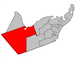 Location within Gloucester County, New Brunswick | |
| Coordinates: 47.46°N 65.86°W | |
| Country | |
| Province | |
| County | Gloucester |
| Erected | 1827 |
| Area | |
| • Land | 1,504.87 km2 (581.03 sq mi) |
| Population (2016)[1] | |
| • Total | 4,797 |
| • Density | 3.2/km2 (8/sq mi) |
| • Pop 2011-2016 | |
| • Dwellings | 2,292 |
| Time zone | UTC-4 (AST) |
| • Summer (DST) | UTC-3 (ADT) |
For governance purposes it is divided between the city of Bathurst, the town of Beresford, Indian reserve Pabineau 11 and the local service districts of Allardville, Big River, Dunlop, New Bandon-Salmon Beach, North Tetagouche, and the parish of Bathurst, all of which except the Indian reserve are members of the Chaleur Regional Service Commission (CRSC).[3]
Origin of name
The parish was named for Earl Bathurst, British Secretary of State for War and the Colonies at the time of its erection.[4]
History
Bathurst was erected in 1827 from the western part of Saumarez Parish.[5] Its eastern boundary followed Teagues Brook to its head and ran south to the county line.
In 1850 the eastern boundary was altered to match the northern end of the modern parish line and its prolongation to the county line, trading areas with New Bandon Parish.[6]
In 1947 a large area in the southeastern part of the parish was included in the newly erected Allardville Parish.[7]
Delineation
Bathurst Parish is defined in the Territorial Division Act[2] as:
- Beginning at a point in the shoreline of the Chaleur Bay where the same is intersected by the eastern prolongation of the south limit of Lot Number One, granted to Simon Arceneau; thence in a westerly direction along said prolongation, said limit of said lot and the western prolongation of same to the most northern angle of Northumberland County; thence in a southeasterly and northeasterly direction following the Gloucester-Northumberland County line to a point in the Canadian National Railways; thence in a northerly direction along said railway to a point where the same is intersected by the western prolongation of the south limit of lots lettered A and B, granted to John Porter, said lots situated on both sides of the Highway 8;[lower-alpha 1] thence in an easterly direction along said prolongation, said limit of said lots and the eastern prolongation of same to a point in the west limit of a seven thousand, seven hundred and fifty acre tract, granted to Henry H. Swinny, situated on the head of the Big Tracadie River; thence in a southerly direction along said limit of said grant and its southern prolongation to a point in the north limit of Tier one north, Allardville East [Settlement]; thence in an easterly direction along said limit of Allardville East to a point where the same is intersected by the southern prolongation of the east limit of Lot Number twenty-nine, granted to Jacob Tague, said lot fronting on the Chaleur Bay at the mouth of Teagues Brook; thence in a northerly direction along said prolongation and said limit of said lot to a point in the shore line of Chaleur Bay; and thence following the various courses of said shoreline to the place of beginning. Including all islands in front thereof.
Communities
Parish population total does not include incorporated municipalities (in bold):
|
|
|
Demographics
Population
| Canada census – Bathurst Parish, New Brunswick community profile | |||
|---|---|---|---|
| 2016 | 2011 | 2006 | |
| Population: | 4,797 (-3.7% from 2011) | 4,979 (-3.2% from 2006) | 5,144 (-6.4% from 2001) |
| Land area: | 1,504.87 km2 (581.03 sq mi) | 1,504.80 km2 (581.01 sq mi) | 1,504.23 km2 (580.79 sq mi) |
| Population density: | 3.2/km2 (8.3/sq mi) | 3.3/km2 (8.5/sq mi) | 3.4/km2 (8.8/sq mi) |
| Median age: | 50.1 (M: 50.1, F: 50.1) | 47.1 (M: 47.7, F: 46.7) | 43.1 (M: 43.8, F: 42.4) |
| Total private dwellings: | 2,292 | 2,223 | 2,272 |
| Median household income: | $64,597 | $54,540 | $52,487 |
| References: 2016[8] 2011[9] 2006[10] earlier[11] | |||
|
|
| |||||||||||||||||||||||||||
| [12][1] | |||||||||||||||||||||||||||||
Language
| Canada Census Mother Tongue – Bathurst Parish, New Brunswick[12] | ||||||||||||||||||
|---|---|---|---|---|---|---|---|---|---|---|---|---|---|---|---|---|---|---|
| Census | Total | French |
English |
French & English |
Other | |||||||||||||
| Year | Responses | Count | Trend | Pop % | Count | Trend | Pop % | Count | Trend | Pop % | Count | Trend | Pop % | |||||
2011 |
4,965 |
2,435 | 49.04% | 2,395 | 48.24% | 105 | 2.11% | 30 | 0.60% | |||||||||
2006 |
5,130 |
2,325 | 45.32% | 2,660 | 51.85% | 75 | 1.46% | 70 | 1.36% | |||||||||
2001 |
5,485 |
2,710 | 49.41% | 2,630 | 47.95% | 115 | 2.10% | 30 | 0.55% | |||||||||
1996 |
5,775 |
3,035 | n/a | 52.55% | 2,600 | n/a | 45.02% | 130 | n/a | 2.25% | 10 | n/a | 0.17% | |||||
See also
Notes
- Now part of Route 134
References
- "Census Profile, 2016 Census: Bathurst, Parish [Census subdivision], New Brunswick". Statistics Canada. Retrieved September 9, 2019.
- "Chapter T-3 Territorial Division Act". Government of New Brunswick. Retrieved 13 November 2020.
- "Communities in each of the 12 Regional Service Commissions (RSC) / Les communautés dans chacune des 12 Commissions de services régionaux (CSR)" (PDF), Government of New Brunswick, July 2017, retrieved 2 February 2021
- Ganong, William F. (1896). A Monograph of the Place-Nomenclature of the Province of New Brunswick. Royal Society of Canada. p. 219.
- "7 Geo. IV c. 31 An Act for the division of the County of Northumberland into three Counties, and to provide for the Government and Representation of the two new Counties.". Acts of the General Assembly of His Majesty's Province of New-Brunswick, Passed in the Year 1827. Fredericton: Government of New Brunswick. 1827. pp. 97–103.
- "13 Vic. c. 51 An Act to consolidate all the Laws now in force for the division of the Province into Counties, Towns and Parishes.". Acts of the General Assembly of Her Mjaesty's Province of New Brunswick, Passed in the Year 1850. Fredericton: Government of New Brunswick. 1850. pp. 142–152, 145–149. Book was poorly proofread, resulting in title typo and reuse of page numbers 145–152.
- "10 Geo. VI. c. 90 An Act to amend the Act respecting the division of the Province into Counties, Towns and Parishes, in so far as it relates to the County of Gloucester". Acts of the Legislative Assembly of New Brunswick Passed During the Session of 1946. Fredericton: Government of New Brunswick. 1946. pp. 301–309.
- "2016 Community Profiles". 2016 Canadian Census. Statistics Canada. February 21, 2017. Retrieved 2019-09-09.
- "2011 Community Profiles". 2011 Canadian Census. Statistics Canada. July 5, 2013. Retrieved 2014-04-06.
- "2006 Community Profiles". 2006 Canadian Census. Statistics Canada. March 30, 2011. Retrieved 2014-04-06.
- "2001 Community Profiles". 2001 Canadian Census. Statistics Canada. February 17, 2012.
- Statistics Canada: 1996, 2001, 2006, 2011 census
Places adjacent to Bathurst Parish, New Brunswick | ||||||||||
|---|---|---|---|---|---|---|---|---|---|---|
| ||||||||||
| Subdivisions | |
|---|---|
| Cities | |
| Counties | |
| |