Saumarez Parish, New Brunswick
Saumarez is a civil parish in Gloucester County, New Brunswick, Canada.[2]
Saumarez | |
|---|---|
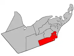 Location within Gloucester County, New Brunswick map erroneously puts barrier islands opposite Tracadie in Inkerman Parish | |
| Coordinates: 47.5°N 64.94°W | |
| Country | |
| Province | |
| County | Gloucester |
| Erected | 1814 |
| Area | |
| • Land | 326.78 km2 (126.17 sq mi) |
| Population (2016)[1] | |
| • Total | 6,818 |
| • Density | 20.9/km2 (54/sq mi) |
| • Pop 2011-2016 | |
| • Dwellings | 3,111 |
| Time zone | UTC-4 (AST) |
| • Summer (DST) | UTC-3 (ADT) |
Before the formation of the Regional Municipality of Grand Tracadie-Sheila in 2014, Saumarez Parish was subdivided into one town and twelve local service districts, with an additional special service area within the parish LSD.
Tracadie is a member of the Acadian Peninsula Regional Service Commission (APRSC).[3]
Origin of name
The parish was named in honour of Sir Thomas Saumarez, acting Governor of New Brunswick when it was erected.[4] Six of the parishes erected simultaneously in Northumberland County in 1814[5] were named for prominent British military figures.
History
Saumarez was erected in 1814 as part of Northumberland County from unassigned territory.[5] It included most of modern Gloucester County.
In 1827 Bathurst was erected as its own parish.[6]
In 1831 Caraquet and New Bandon were erected as their own parishes.[7]
In 1855 Inkerman was erected from the northern part of Saumarez.[8]
In 1870 the boundary with Inkerman was adjusted.[9]
In 1881 Saint-Isidore Parish included part of Saumarez[10]
In 1947 part of Saumarez was included in the newly erected Allardville.[11]
Delineation
Saumarez Parish is defined in the Territorial Division Act[2] as being bounded:
- Bounded easterly by the Gulf of St. Lawrence and northerly, westerly and southerly by the following described bounds: Beginning at a point in the most western extremity of a twenty acre lot granted to F. Vienneau,[lower-alpha 1] situated at the easterly entrance of the Tracadie Lagoon;[lower-alpha 2] thence northwesterly in a direct line across said Lagoon to the mouth of LeBouthillier Brook; thence in a northwesterly direction following the various courses of said brook upstream to Highway 11[lower-alpha 3] leading from Tracadie[lower-alpha 4] to Pokemouche; thence in a direct line to the northeast angle of lot number one hundred and forty-five, granted to Dosite Landry, situated on the north side of the Saint-Isidore Road;[lower-alpha 5] thence in a westerly direction along the north limit of said lot to a point where the same is intersected by a direct line extending from the southeast angle of lot number one hundred and forty-four, granted to Dos. Landry, to the Southwest angle of lot number five, granted to Joseph Lavigne, in Range Six, Val-Doucet;[lower-alpha 6] thence in a southeasterly direction along said direct line to the southeast angle of aforesaid lot number one hundred and forty-four, granted to Dos. Landry; thence in a westerly direction along the south limit of said lot to a point where the same is intersected by the west bank or shore of Gaspereau Creek; thence in a southerly direction along said bank or shore to a point in the southern limit of lot number one hundred and forty-two, granted to M. Gottro; thence in a westerly direction along the southern limit of said lot and said limit of lot number three hundred and six, granted to George Savoy, and lot number three hundred and nine, granted to A. Basque, to a point in the eastern limit of lot number one, granted to T. Richard; thence in a southerly direction along said limit of said lot to the southeast angle of the same; thence in a westerly direction along the south limit of Range Six, Saint-Isidore [Settlement], to the northwest angle of lot number two hundred and eighty-nine, granted to Canute Arceno, situated in the Second Tier North of the Little Tracadie River; thence in a southerly direction along the west limit of said lot and said limit of lot number thirty, granted to Richard Arseneault, to a point in the north bank or shore of the aforesaid River; thence following the said bank or shore upstream to a point where the same is intersected by the south limit of Range Nine, Saint-Isidore; thence in a westerly direction along said limit of said Range and its western prolongation to a point in the Division line between Timber Block Numbers Three and Four, Range Eight; thence in a southerly direction along said Division line in Ranges Eight, Nine and Ten to a point in the Gloucester-Northumberland County County line; and thence in an easterly direction along said County line to the Gulf of St. Lawrence.
Governance
The entire parish is part of the Regional Municipality of Tracadie.
Communities
Parish population total does not include incorporated municipalities (in bold):
|
|
|
Demographics
Population
| Canada census – Saumarez Parish, New Brunswick community profile | |||
|---|---|---|---|
| 2016 | 2011 | 2006 | |
| Population: | 6,818 (-1.5% from 2011) | 6,920 (+1.3% from 2006) | 6,837 (-1.8% from 2001) |
| Land area: | 326.78 km2 (126.17 sq mi) | 326.78 km2 (126.17 sq mi) | 326.76 km2 (126.16 sq mi) |
| Population density: | 20.9/km2 (54/sq mi) | 21.2/km2 (55/sq mi) | 20.9/km2 (54/sq mi) |
| Median age: | 49.2 (M: 48.5, F: 49.8) | 45.9 (M: 45.5, F: 46.3) | 42.4 (M: 42.1, F: 42.6) |
| Total private dwellings: | 3,111 | 3,016 | 2,911 |
| Median household income: | $56,029 | $47,379 | $39,462 |
| References: 2016[16] 2011[17] 2006[18] earlier[19] | |||
|
|
| ||||||||||||||||||||||||||||||
(A) adjustment due to boundary change [20][21][1] | ||||||||||||||||||||||||||||||||
Language
| Canada Census Mother Tongue - Saumarez Parish, New Brunswick[20] | ||||||||||||||||||
|---|---|---|---|---|---|---|---|---|---|---|---|---|---|---|---|---|---|---|
| Census | Total | French |
English |
French & English |
Other | |||||||||||||
| Year | Responses | Count | Trend | Pop % | Count | Trend | Pop % | Count | Trend | Pop % | Count | Trend | Pop % | |||||
2011 |
6,870 |
6,695 | 97.45% | 125 | 1.82% | 45 | 0.65% | 5 | 0.08% | |||||||||
2006 |
6,805 |
6,610 | 97.13% | 140 | 2.06% | 25 | 0.37% | 30 | 0.44% | |||||||||
2001 |
6,935 |
6,830 | 98.49% | 75 | 1.08% | 30 | 0.43% | 0 | 0.00% | |||||||||
1996 |
7,370 |
7,150 | n/a | 97.02% | 180 | n/a | 2.44% | 40 | n/a | 0.54% | 0 | n/a | 0.00% | |||||
See also
Notes
References
- "Census Profile, 2016 Census: Saumarez, Parish [Dissolved census subdivision], New Brunswick". Statistics Canada. Retrieved September 8, 2019.
- "Chapter T-3 Territorial Division Act". Government of New Brunswick. Retrieved 13 November 2020.
- "Communities in each of the 12 Regional Service Commissions (RSC) / Les communautés dans chacune des 12 Commissions de services régionaux (CSR)" (PDF), Government of New Brunswick, July 2017, retrieved 2 February 2021
- Ganong, William F. (1896). A Monograph of the Place-Nomenclature of the Province of New Brunswick. Royal Society of Canada. p. 271.
- "54 Geo. III c. 17 An Act in further addition to an Act, intituled "An Act for the better ascertaining and confirming the boundaries of the several Counties, within this Province, and for subdividing them into Towns or Parishes."". Acts of the General Assembly of His Majesty's Province of New-Brunswick; Passed in the Year 1814. Saint John, New Brunswick: Government of New Brunswick. 1814. pp. 16–18.
- "7 Geo. IV c. 31 An Act for the division of the County of Northumberland into three Counties, and to provide for the Government and Representation of the two new Counties.". Acts of the General Assembly of His Majesty's Province of New-Brunswick, Passed in the Year 1827. Fredericton: Government of New Brunswick. 1827. pp. 97–103.
- "1 Wm. IV c. 19 An Act to erect Two new Parishes in the County of Gloucester.". Acts of the General Assembly of His Majesty's Province of New-Brunswick, Passed in the Year 1831. Fredericton: Government of New Brunswick. 1831. pp. 68–69.
- "18 Vic. c. 47 An Act for dividing the Parish of Saumarez, in the County of Gloucester, into two separate Parishes.". Acts of the General Assembly of Her Majesty's Province of New Brunswick, Passed in the Month of November, 1854, and in the Months of February, March, and April, 1855. Fredericton: Government of New Brunswick. 1855. pp. 176–177.
- "33 Vic. c. 11 An Act to alter the Division Line between the Parishes of Saumarez and Inkerman, in the County of Gloucester.". Acts of the General Assembly of Her Majesty's Province of New Brunswick Passed in the Months of March & April 1870. Fredericton: Government of New Brunswick. 1870. p. 20.
- "44 Vic. c. 34 An Act to erect part of the Parishes of Saumarez and Inkerman, in the County of Gloucester, into a separate Parish.". Acts of the General Assembly of Her Majesty's Province of New Brunswick. Passed in the Month of March 1881. Fredericton: Government of New Brunswick. 1881. pp. 70–72.
- "10 Geo. VI. c. 90 An Act to amend the Act respecting the division of the Province into Counties, Towns and Parishes, in so far as it relates to the County of Gloucester". Acts of the Legislative Assembly of New Brunswick Passed During the Session of 1946. Fredericton: Government of New Brunswick. 1946. pp. 301–309.
- "Crown Grant Reference Map Viewer". GeoNB. Government of New Brunswick. Retrieved 25 August 2016.
- "Tracadie North Gully". Canadian Geographical Names. Natural Resources Canada. Retrieved 26 August 2016.
- "Baie de Tracadie". Canadian Geographical Names. Natural Resources Canada. Retrieved 26 August 2016.
- "No. 095" (PDF). 2015 Designated Highway Maps. Government of New Brunswick. Retrieved 25 August 2016.
- "2016 Community Profiles". 2016 Canadian Census. Statistics Canada. February 21, 2017. Retrieved 2019-09-08.
- "2011 Community Profiles". 2011 Canadian Census. Statistics Canada. July 5, 2013. Retrieved 2014-03-30.
- "2006 Community Profiles". 2006 Canadian Census. Statistics Canada. March 30, 2011. Retrieved 2014-03-30.
- "2001 Community Profiles". 2001 Canadian Census. Statistics Canada. February 17, 2012.
- Statistics Canada: 1996, 2001, 2006, 2011 census
- 2011 Statistics Canada Census Profile: Saumarez Parish, New Brunswick
Places adjacent to Saumarez Parish, New Brunswick | |
|---|---|
| Subdivisions | |
|---|---|
| Cities | |
| Counties | |
| |