Alxa Left Banner
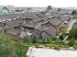
Alxa Left Banner (Mongolian: ᠠᠯᠠᠱᠠ ᠵᠡᠭᠦᠨ ᠬᠣᠰᠢᠭᠤ Alaša Jegün qosiɣu; Chinese: 阿拉善左旗; pinyin: Ālāshàn Zuǒ Qí) is a banner (administrative division) in the southwest of Inner Mongolia, China. It borders the Republic of Mongolia's Ömnögovi Province to the north, the autonomous region of Ningxia to the southeast, and Gansu province to the southwest. The town of Bayanhot/Bayenhot (Tingyuanying) (巴彦浩特镇), situated in the banner, is the seat of government of the greater Alxa League, of which Alxa Left Banner is a part.
Alxa Left Banner
阿拉善左旗 • ᠠᠯᠠᠱᠠᠵᠡᠭᠦᠨᠬᠣᠰᠢᠭᠤ | |
|---|---|
 | |
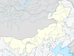 Alxa Left Location of the seat in Inner Mongolia | |
| Coordinates (Alxa Left Banner government): 38°50′00″N 105°39′59″E | |
| Country | People's Republic of China |
| Autonomous region | Inner Mongolia |
| League | Alxa |
| Incorporation into Qing Empire | 1697 |
| Banner founded | 1961 |
| Named for | Alxa League |
| Seat | Bayanhot |
| Area | |
| • Total | 80,412 km2 (31,047 sq mi) |
| Population (2013) | |
| • Total | 143,089 |
| Time zone | UTC+8 (China Standard) |
| Postal code | 750306 |
| Area code(s) | 0483 |
Alxa Left Banner is on the route of provincial highway S218, which is accessible via China National Highway 110 via the city of Wuhai. It is also accessible by air via the Alxa Left Banner Bayanhot Airport.
Ethnic Mongols make up 27% of the banner population.[1]
The average elevation is between 800 and 1500 meters above sea level. A large part of the banner is desert.
The banner is subdivided into four subdistricts, 8 towns, and 6 sumus and one Economic and Technological Development Zone.[2]
References
- 阿拉善左旗2013年国民经济和社会发展统计公报. Archived from the original on 2016-03-04. Retrieved 2015-07-19.
- 2018年统计用区划代码和城乡划分代码:阿拉善左旗 (in Chinese). National Bureau of Statistics of the People's Republic of China. 2018. Retrieved 2020-02-05.
- www.xzqh.org (in Chinese)
| Authority control |
|---|
