Horqin Right Middle Banner
Horqin Right Middle Banner (Mongolian script: ᠬᠣᠷᠴᠢᠨ ᠪᠠᠷᠠᠭᠤᠨ ᠭᠠᠷᠤᠨ ᠳᠤᠮᠳᠠᠳᠤ ᠬᠣᠰᠢᠭᠤ; Chinese: 科尔沁右翼中旗) is a banner in the east of Inner Mongolia, China, bordering Jilin province to the east. It is under the administration of Hinggan League. The local Mongolian dialect is Khorchin Mongolian. The banner spans an area of 15,613 square kilometers in area, and has a population of 255,494 as of 2010.[1]
Horqin Right Middle Banner
科尔沁右翼中旗 • ᠬᠣᠷᠴᠢᠨᠪᠠᠷᠠᠭᠤᠨᠭᠠᠷᠤᠨᠳᠤᠮᠳᠠᠳᠤᠬᠣᠰᠢᠭᠤ | |
|---|---|
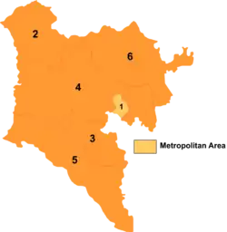 Hinggan divisions: Horqin Right Middle Banner is 5 on this map | |
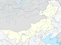 Horqin YYZQ Location of the seat in Inner Mongolia | |
| Coordinates (Horqin Right Middle Banner government): 45.061°N 121.477°E | |
| Country | People's Republic of China |
| Autonomous region | Inner Mongolia |
| League | Hinggan |
| Area | |
| • Total | 15,613 km2 (6,028 sq mi) |
| Population (2010)[1] | |
| • Total | 255,494 |
| • Density | 16/km2 (42/sq mi) |
| Time zone | UTC+8 (China Standard) |
| Postal code | 029400 |
| Website | http://www.kyzq.gov.cn/ |
| Horqin Right Middle Banner | |||||||
|---|---|---|---|---|---|---|---|
| Chinese name | |||||||
| Simplified Chinese | 科尔沁右翼中旗 | ||||||
| Traditional Chinese | 科爾沁右翼中旗 | ||||||
| |||||||
| Mongolian name | |||||||
| Mongolian Cyrillic | Хорчин Баруун Гарын Дундад Хошуу | ||||||
| Mongolian script | ᠬᠣᠷᠴᠢᠨᠪᠠᠷᠠᠭᠤᠨᠭᠠᠷᠤᠨᠳᠤᠮᠳᠠᠳᠤᠬᠣᠰᠢᠭᠤ | ||||||
| |||||||
Name
"Horqin" in Mongolian translates to "archer".[1] The area was also historically known as the Tushiyetu Banner (图什业图旗) and the Ke Right Middle Banner (科右中旗).[1]
Geography
It borders Horqin Right Front Banner and Tuquan County to the north, Tongyu County and Taonan in Jilin Province to the east, Horqin Left Middle Banner to the south, and Jarud Banner, Huolinguole and East Ujimqin Banner to the west.[1]
The banner's main rivers include the Holin Gol, the Kunduleng Gol, the Emuting Gol, and the Wunugeqi Gol.[2]
Climate
The average annual temperature is 5.6 °C, and the annual precipitation is typically between 350 and 400 mm.[2]
History
A segment of the Jin Dynasty Great Wall runs through the banner.[2] The Jin Dynasty city of Tuliemao (吐列毛) was located in the banner, and its ruins of the city still exist within the banner.[2]
Horqin Right Middle Banner was established in 1636.[1]
Administrative divisions
The banner is divided into 6 towns, 6 sumu, 1 township-level ranch, 1 township-level farm, and 2 township-level mines.[2][3] The banner's seat of government is the town of Bayanhushu.[2] These township-level divisions are then further divided into 173 gaqa and 464 aili (艾里).[1]
Towns
Horqin Right Middle Banner has 6 towns: Bayanhushu, Barenzhelimu, Tuliemaodou, Du'erji, Gaoliban, and Haoyaosumu.[3]
Sumu
Horqin Right Middle Banner has 6 sumu: Daiqintala Sumu, Xinjiamu Sumu, Harinuo'er Sumu, Emutinggaolei Sumu, Bayanmangha Sumu, and Bayannao'er Sumu.[3]
Other township-level divisions
In addition to towns and sumu, Horqin Right Middle Banner administers a number of special areas with township-level designation.
Budunhua Ranch
The banner is home to Budunhua Ranch, which serves as a township-level division.[3]
Tuliemaodu Farm
The banner is home to Tuliemaodu Farm, which serves as a township-level division.[3]
Meng'entaoligai Mine Work Unit
The banner is home to the Meng'entaoligai Mine Work Unit, which serves as a township-level division.[3]
Budunhua Mine Work Unit
The banner is home to the Budunhua Mine Work Unit, which serves as a township-level division.[3]
Demographics
The banner has a population of 255,494 people, hailing from 14 different ethnic groups.[1] The ethnic Mongolian population is dominant in the banner, accounting for 86.6% of the total population, the highest proportion of any banner.[1]
Economy
As of 2016, the banner's GDP totaled 6.596 billion Yuan, government revenue totaled 232 million Yuan, urban per capita disposable income reached 21,700 Yuan, and rural per capita disposable income reached 7,904 Yuan.[4]
The banner's main mineral deposits include gold, tin, copper, iron, lead, zinc, coal, rare earth minerals, perlite, and quartz.[2]
Transportation
The Tongliao-Holin Gol railway passes through the banner, as does National Highway 110.[2]
References
- 人口民族. Horqin Right Middle Banner People's Government (in Chinese). 2020-04-24. Archived from the original on 2020-07-09. Retrieved 2020-07-09.
- 科尔沁右翼中旗概况地图. xzqh.org (in Chinese). 2013-04-12. Archived from the original on 2020-07-09. Retrieved 2020-07-09.
- 2019年统计用区划代码. stats.gov.cn (in Chinese). 2019. Archived from the original on 2020-07-09. Retrieved 2020-07-09.
- 经济发展. Horqin Right Middle Banner People's Government (in Chinese). 2017-06-13. Archived from the original on 2020-07-09. Retrieved 2020-07-09.
| Authority control |
|
|---|