Dorbod Banner
Dorbod (Siziwang) Banner (Mongolian: ᠳᠥᠷᠪᠡᠳ ᠬᠣᠰᠢᠭᠤ Dörbed qosiɣu, Дөрвөд хошуу, Dörwöd hoşú; Chinese: 四子王旗; pinyin: Sìzǐwáng Qí) is a banner (county equivalent) in Ulanqab, Inner Mongolia, China,[1] bordering Mongolia's Dornogovi Province to the northwest. It is located about 80 km (50 mi) north of Hohhot, the capital of Inner Mongolia.
Dorbod Banner
四子王旗 · ᠳᠥᠷᠪᠡᠳ ᠬᠣᠰᠢᠭᠤ | |
|---|---|
 | |
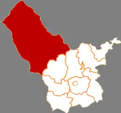 Dorbod in Ulanqab | |
.svg.png.webp) Ulanqab in Inner Mongolia | |
| Coordinates: 41°31′59″N 111°42′24″E | |
| Country | People's Republic of China |
| Province | Inner Mongolia |
| Prefecture-level city | Ulanqab |
| Area | |
| • Total | 25,513 km2 (9,851 sq mi) |
| Population (2009) | |
| • Total | 216,990 |
| • Density | 8.5/km2 (22/sq mi) |
| Time zone | UTC+8 (China Standard) |
The banner spans 25,513 square kilometres (9,851 sq mi), and has a population of 216,990 as of 2009.[2] Its seat of government is located in Wulanhua.[3]
Toponymy
The Chinese name for the banner siziwang, literally "four princes", derives from the area's historic rule by four brothers.[2] The Mongolian name for the banner dorbed means "of four".
History
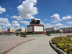
The area of Dorbod Banner was ruled by four Mongol brothers, Sengge (Chinese: 僧格), Suonuobu (Chinese: 索諾布), Emubu (Chinese: 鄂木布) and Yi'erzhamu (Chinese: 伊爾扎木), who were descendants of Hasar, a brother of Genghis Khan. They led their tribe in participating in the Manchu Qing Dynasty's conquest of Ming China in the early 17th century. In recognition of their service, the Qing court made Emubu the Duoluo Commandery Prince (Chinese: 多羅郡王) in 1649 and settled their tribe in the area of modern Siziwang Banner. The title was hereditary and passed through fourteen of his descendants before the Communist Party of China abolished all hereditary titles in Inner Mongolia in 1949. The last prince, Sudanamuchaogeji (Chinese: 蘇達那木朝格吉), died as a private citizen in 1957. There is a sculpture of the four original princes in Wulanhua, erected in 2003.
Geography
To its east lies Sonid Right Banner, Qahar Right Rear Banner, and Qahar Right Middle Banner.[3] To its south lies Wuchuan County and Zhuozi County.[3] To its west lies Darhan Muminggan United Banner.[3] Its north is formed by a 104 kilometres (65 mi) bordr with Mongolia.[3]
Its seat of government, the town of Wulanhua, is located 105 kilometres (65 mi) away from Hohhot, and 270 kilometres (170 mi) away from Erlianhot.[3]
The banner is located along the northern foothills of the Yin Mountains, and has an average elevation of 1,400 metres (4,600 ft).[3] Most of the banner's area is grassland.[3]
Administrative divisions
Dorbod Banner is divided into five towns, three townships, five sumu, and one other township-level division.[4]
The banner's five towns are Wulanhua, Jishengtai, Kuluntu, Gongjitang, and Baiyinchaoketu.[4]
The banner's three townships are Dongbahao Township, Hujitu Township, and Daheihe Township.[4]
The banner's five sumu are Honggor Sumu, Jiang'an Sumu, Chaganbulige Sumu, Naomugeng Sumu, and Bayin'aobao Sumu.[4]
The banner is also home to Wulan Ranch.[4]
Demographics
As of 2009, the banner is home to 216,990 people, up from the 180,568 reported in the 2000 Census.[2]
The banner's ethnic minorities include 18,902 Mongols (8.71% of the total population), 1,086 Manchus (0.50%), and 837 Hui people (0.39%).[2]
Economy
Mineral deposits in the banner include gold, copper, nickel, manganese, fluorite, gypsum, coal, and thenardite.[3]
Spacecraft landing site
The banner served as the landing sites for China's Shenzhou program.[5]
A pasture known as Amugulang, located in Honggor Sumu, about 60 km (37 mi) north of Wulanhua, served as the landing site for the Shenzhou-6 spacecraft.[6] A specially constructed 64.69 km (40.20 mi) road runs from Wulanhua to Honggor to aid the recovery of the Shenzhou spacecraft, and to boost the local economy.[6] This road shortened the journey between the two towns from two hours to just 40 minutes.[6]
Chinese space program recovery teams (with SUV and recovery trucks) track the progress of re-entry near the landing site and arrive shortly after landing.[7]
A small recovery trucks fitted with a crane lifts the capsule and places it on the rear of the truck for transportation back to the space centre.
Since the final Shenzhou landing in Dorbod Banner in 2016, new facilities have been built to hasten the retrieval process for various spacecraft.
In December 2020, the Chang'e 5 spacecraft landed in Dorbod Banner following a successful collection of moon rocks.[5]
See also
Notes
- ^ — All of the names presented here are transcribed from Chinese language sources using Hanyu Pinyin into the Roman alphabet. However, as these names are Mongolian and/or Manchu in origin, it would be much more accurate to transcribe them directly from those languages. These transcriptions are, however, unavailable as of now.
References
Citations
- 2020年统计用区划代码(乌兰察布市) (in Chinese). National Bureau of Statistics of China. 2020. Archived from the original on 2020-12-17. Retrieved 2020-12-17.
- 四子王旗历史沿革. xzqh.org (in Chinese). 2013-04-16. Archived from the original on 2020-12-17. Retrieved 2020-12-17.
- 四子王旗概况地图. xzqh.org (in Chinese). 2013-04-16. Archived from the original on 2020-12-17. Retrieved 2020-12-17.
- 2020年统计用区划代码(四子王旗) (in Chinese). National Bureau of Statistics of China. 2020. Archived from the original on 2020-12-17. Retrieved 2020-12-17.
- "Chinese Capsule Returns to Earth Carrying Moon Rocks". Time. 2020-12-16. Archived from the original on 2020-12-17. Retrieved 2020-12-17.
- "People's Daily Online -- Primary landing site ready to greet Chinese taikonauts back home". people.cn. 2005-10-15. Archived from the original on 2020-12-18. Retrieved 2020-12-18.
- Shenzhou 5 Archived 2011-06-28 at the Wayback Machine
News
- "Primary landing site ready to greet taikonauts back". Xinhua News Agency. 2005-10-14.