Ergun City
Ergun (simplified Chinese: 额尔古纳市; traditional Chinese: 額爾古納市; pinyin: É'ěrgǔnà-shì; Mongolian: Эргүн Ergün), formerly Ergun Right Banner (Mongolian: ᠡᠷᠬᠥᠨᠠ ᠬᠣᠲᠠ Эргүнэ хот; Chinese: 额尔古纳右旗; pinyin: E'erguna You Qi), is a county-level city in Hulunbuir, Inner Mongolia, containing the autonomous region's northernmost point. The city has an area of 28,958 square kilometres (11,181 sq mi),[2] and a population of 76,667 as of the 2010 Chinese Census.[3]
Ergun
额尔古纳市 • ᠡᠷᠬᠥᠨᠠᠬᠣᠲᠠ | |
|---|---|
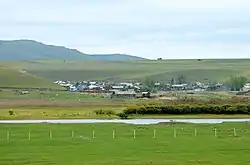 Village on the Argun River | |
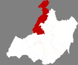 Ergun in Hulunbuir | |
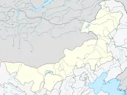 Ergun Location in Inner Mongolia | |
| Coordinates: 50°14′35″N 120°10′52″E | |
| Country | People's Republic of China |
| Autonomous region | Inner Mongolia |
| Prefecture-level city | Hulunbuir |
| Area | |
| • County-level city | 28,400 km2 (11,000 sq mi) |
| • Urban | 303.00 km2 (116.99 sq mi) |
| Population (2017) | |
| • County-level city | 85,162 |
| • Density | 3.0/km2 (7.8/sq mi) |
| • Urban | 38,100 |
| Time zone | UTC+8 (China Standard) |
| Postal code | 022050 |
| Area code(s) | 0470 |
| Website | www |
History
For most of its history, the region of present-day Ergun has not been controlled by Chinese states.[3] The area first came under Chinese control during the Qing dynasty, when it was administered as part of Hulunbuir.[3]
In 1908, the Jilalin Administrative Bureau (Chinese: 吉拉林设治局; pinyin: Jílālín Shèzhì Jú) was established to govern the area.[3]
In 1920, the area was re-organized as the Qigan Administrative Bureau (Chinese: 奇乾设治局; pinyin: Qígān Shèzhì Jú), but the area was re-organized again in 1921 as Qigan County (Chinese: 奇乾县; pinyin: Qígān Xiàn).[3]
In 1933, the area was re-organized as Ergun Right Banner (Chinese: 额尔古纳右旗; pinyin: É'ěrgǔnà Yòu Qí).[3] From 1948 to 1966, Ergun Right Banner was merged with Ergun Left Banner, which occupied present-day Genhe, as Ergun Banner.[3] In 1994, Ergun Right Banner was abolished and the county-level city of Ergun was established.[3]
21st century
By 2000, the city administered five towns, one township, and two ethnic townships.[3] In 2001, the city was restructured to administer one subdistrict, two towns, one township, and two ethnic townships.[3]
In 2006, Xincheng Subdistrict (Chinese: 新城街道; pinyin: Xīnchéng Jiēdào) was renamed to Labudalin Subdistrict, and Shangkuli Township (Chinese: 上库力乡; pinyin: Shàngkùlì Xiāng) was upgraded to Shangkuli Subdistrict.[3]
In 2011, Shiwei Russian Ethnic Township (Chinese: 室韦俄罗斯族民族乡; pinyin: Shìwéi Èluósī Zú Mínzú Xiāng) was abolished and Enhe Russian Ethnic Township and Mengwu Shiwei Sum were established.[3] Enhehada was also established.[3]
In 2013, Qigan Township was established.[3]
Geography

Administratively, Ergun is part of the prefecture-level city of Hulunbuir, and spans 11.4% of Hulunbuir's area.[2][4] It occupies 28,958 square kilometres (11,181 sq mi), bounded to the north and west by the Argun River, which forms China's border with Russia's Zabaykalsky Krai (formerly, Chita Oblast).[2][5] The city's border with Russia spans 675 kilometres (419 mi).[2] Ergun is also bordered by Genhe to the east, and the county-level city of Mohe in Heilongjiang to the northeast.[2]
The city stands at the foothills of the Greater Khingan Mountains.[2] 73.4% of the city's area is forested, with much of it being virgin forests.[2][4] 17% of the city's area is natural grassland, particularly in the city's south, and 6% is cultivated.[2]
Apart from the Argun River, major rivers in the city include the Derbul River, the Gen River, the Hawu'er River, the Jiliu River, the Wuma River, and the Enhehada River, all of which are tributaries of the Argun River.[2]
Ergun Wetlands
The city hosts Ergun Wetlands (formerly known as the Genhe Wetlands), a plain delta formed by the Argun River, the Gen River, the Derbul River, and the Hawu'er River. The Ergun Wetlands is one of the largest wetlands in Asia, lying about 3 km to the west of Labudalin Subdistrict, Ergun's urban area and seat of government.
After the end of September the wetlands wither and turn dark.[6] A panoramic view of the wetlands is afforded from a tourist scenic view overlooking the area from a hill 720 meters above sea level.[7]
The encroachment of urban development has made preservation of the wetland difficult but were bolstered by a wetland protection law in 2012.[8]
Climate
The city experiences an average annual temperature of −3.1 °C (26.4 °F), and an average annual precipitation of 375 millimetres (14.8 in).[2]
Subdivisions
Ergun is divided into two subdistricts, three towns, one township, two ethnic townships, one sum, and four township-level farms.[10]
| English Name | Subdivision type | Chinese | Population (2010)[3] |
|---|---|---|---|
| Labudalin Subdistrict | Subdistrict | Chinese: 拉布大林街道; pinyin: Lābùdàlín Jiēdào | 35,727 |
| Shangkuli Subdistrict | Subdistrict | Chinese: 上库力街道; pinyin: Shàngkùlì Jiēdào | 6,708 |
| Heishantou | Town | Chinese: 黑山头镇; pinyin: Hēishāntóu Zhèn | 2,029 |
| Moridaga | Town | Chinese: 莫尔道嘎镇; pinyin: Mò'ěrdàogā Zhèn | 17,970 |
| Enhehada | Town | Chinese: 恩和哈达镇; pinyin: Ēnhéhādá Zhèn | N/A |
| Qigan Township | Township | Chinese: 奇乾乡; pinyin: Qígān Xiāng | N/A |
| Sanhe Hui Ethnic Township | Ethnic Township | Chinese: 三河回族乡; pinyin: Sānhé Huí Zú Xiāng | 10,648 |
| Enhe Russian Ethnic Township | Ethnic Township | Chinese: 恩和俄罗斯族乡; pinyin: Ēnhé Èluósī Zú Xiāng | N/A |
| Mengwu Shiwei Sum | Sum | Chinese: 蒙兀室韦苏木; pinyin: Méngwù Shìwéi Sūmù | N/A |
| Inner Mongolia Labudalin Ranch | Township-level farm | Chinese: 内蒙古拉布大林农牧场; pinyin: Nèi Ménggǔ Lābùdàlín Nóngmùchǎng | N/A |
| Inner Mongolia Sanhe Stallion Ranch | Township-level farm | Chinese: 内蒙古三河种马场; pinyin: Nèi Ménggǔ Sānhé Zhǒngmǎchǎng | N/A |
| Inner Mongolia Shangkuli Farm | Township-level farm | Chinese: 内蒙古上库力农场; pinyin: Nèi Ménggǔ Shàngkùlì Nóngchǎng | N/A |
| Inner Mongolia Suqin Ranch | Township-level farm | Chinese: 内蒙古苏沁农牧场; pinyin: Nèi Ménggǔ Sūqìn Nóngmùchǎng | N/A |
Demographics
| Ethnic group | 2000[3] | 2006[11] | 2018[12] | |||
|---|---|---|---|---|---|---|
| Number | Percentage | Number | Percentage | Number | Percentage | |
| Han Chinese | 62,224 | 77.43% | 64,591 | 75.84% | 58,778 | 73.53% |
| Mongol | 4,839 | 6.02% | 7,294 | 8.56% | 7,897 | 9.88% |
| Hui | 6,616 | 8.23% | N/A | N/A | 6,583 | 8.23% |
| Russian | 2,713 | 3.38% | 2,468 | 2.90% | 2,613 | 3.27% |
| Manchu | 2,713 | 3.38% | N/A | N/A | N/A | N/A |
| Daur | 763 | 0.95% | N/A | N/A | N/A | N/A |
| Korean | 182 | 0.23% | N/A | N/A | N/A | N/A |
| Evenk | 156 | 0.19% | N/A | N/A | N/A | N/A |
| Oroqen | 63 | 0.08% | N/A | N/A | N/A | N/A |
| Miao | 55 | 0.07% | N/A | N/A | N/A | N/A |
| Tujia | 29 | 0.04% | N/A | N/A | N/A | N/A |
| Sibe | 3 | <0.01% | N/A | N/A | N/A | N/A |
| Yi | 2 | <0.01% | N/A | N/A | N/A | N/A |
| Other | 0 | 0.00% | 10,809 | 12.69% | 4,071 | 5.09% |
| Total | 80,358 | 100.00% | 85,162 | 100.00% | 79,942 | 100.00% |
In Ergun's towns and villages along the Argun River are thousands of descendants of intermarriages between Han Chinese men and Russian women.[13] This Russian descended population forms a large portion of the total number of Russians in China. One of these locations is Enhe Russian Ethnic Township, the sole official ethnic Russian township.[13]
Economy
Ergun's gross domestic product was ¥4.059 billion as of 2019,[14] and ¥4.519 billion as of 2018.[12] As of 2018, 42.1% of the city's gross domestic product came from its primary sector, 11.1% came from its secondary sector, and 46.8% came from its tertiary sector.[12] The city's fiscal revenue in 2018 was ¥333 million, its consumer retail sales totaled ¥1.826 billion, and its foreign trade totaled 56.32 million USD.[12] The per capita disposable income of Ergun's residents totaled ¥28,173 in 2018, and stood at ¥28,928 for urban hukou residents.[12]
Mineral deposits in Ergun include coal, gold, lead, zinc, iron, tungsten, copper, and fluorite.[2]
Agriculture
The total value of Ergun's agriculture, forestry, animal husbandry, and aquaculture industry as of 2018 was ¥3.072 billion.[12]
Tourism
Ergun has a significant tourism industry, attracting 5.733 million tourists in 2019 alone.[14]
The Ergun Wetland Scenic Area (Chinese: 额尔古纳湿地景区) is designated as a AAAA Tourist Attraction.[4]
Enhe Russian Ethnic Township has become a major tourist destination in recent years, attracting about 500,000 tourists in 2017 alone.[15] Much of the town's tourism is derived from its small rural character, as well as its unique intersection of Russian and Chinese culture.[15] Due to the cold climate of the region, most of the ethnic township's tourism takes place in summer months.[15]
Ergun also hosts the ancient ruins of the city of Heishantou and portions of the Great Wall of Jin.[2]
Transportation
Inner Mongolia Provincial Highway 201 and Inner Mongolia Provincial Highway 301 both run through Ergun.[2]
Ergun has two international border crossings: one in Shiwei, and another in Heishantou.[5]
References
- Ministry of Housing and Urban-Rural Development, ed. (2019). China Urban Construction Statistical Yearbook 2017. Beijing: China Statistics Press. p. 46. Retrieved 11 January 2020.
- 额尔古纳市概况地图 [Ergun Overview]. xzqh.org (in Chinese). 2016-01-04. Archived from the original on 2021-02-09. Retrieved 2021-02-09.
- 额尔古纳市历史沿革 [Ergun City Organizational History]. xzqh.org (in Chinese). 2016-01-04. Archived from the original on 2021-02-09. Retrieved 2021-02-09.
- 市情概况 [City Situation] (in Chinese). Ergun Municipal People's Government. 2020-03-11. Archived from the original on 2021-02-09. Retrieved 2021-02-09.
- 市情概述 (in Chinese). Archived from the original on 2012-11-28. Retrieved 2009-10-07.
- Wang, Kaihao (October 17, 2013). "River valley produces wetlands wonder". China Daily.
- "Ergun wetland in Inner Mongolia, one of the largest in Asia". ecns.com. November 11, 2013.
- Wang, Qian; Zheng, Jinran (May 14, 2012). "Ergun wetland threatened by development, urbanization". China Daily.
- 额尔古纳市拉布大林街道办事处 (in Chinese). Archived from the original on 2011-07-10. Retrieved 2009-10-07.
- 2020年统计用区划代码(额尔古纳) [2020 Statistical Division Codes (Ergun)] (in Chinese). National Bureau of Statistics of China. 2020. Archived from the original on 2021-02-09. Retrieved 2021-02-09.
- 额尔古纳市概况 [Description of Ergun City]. Hulunbuir People's Government (in Chinese).
- 额尔古纳市2018年国民经济和社会发展统计公报 [Ergun City 2018 Economic and Social Development Report] (in Chinese). Ergun Municipal People's Government. 2019-04-01. Archived from the original on 2019-04-13. Retrieved 2021-02-09.
- Entangled Histories: The Transcultural Past of Northeast China (PDF). London: Springer. 2014. pp. 47–58.
- 额尔古纳经济发展概况 [Ergun Economic Development Overview] (in Chinese). Ergun Municipal People's Government. 2020-03-11. Archived from the original on 2021-02-09. Retrieved 2021-02-09.
- Zhang, Wei (2017-08-03). 中国唯一俄罗斯民族乡:异域风情范儿的边疆小镇 [China's only Russian Ethnic Township: An exotic frontier town]. www.chinanews.com (in Chinese). China News Service. Archived from the original on 2021-02-09. Retrieved 2021-02-09.