Amazon Basin (sedimentary basin)
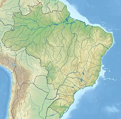
The Amazon Basin is a major 620,000 square kilometres (240,000 sq mi) large sedimentary basin located roughly at the middle and lower course of the Amazon River, south the Guiana Shield and north of the Central Brazilian Shield. It is bound to the west by the Púrus Arch, separating the Amazon Basin from the Solimões Basin and in the east by the Gurupá Arch, separating the basin from the Marajó Basin.[1] The basin developed on a rift that originated possibly about 550 million years ago during the Cambrian. Parts of the rift were reactivated during the opening of the South Atlantic.[2]
| Amazon Basin | |
|---|---|
| Bacia do Amazonas | |
 | |
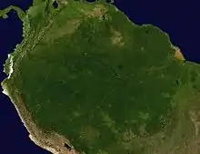 The basin is located in the center and center-right of the picture | |
| Coordinates | 2°29′47″S 57°3′25″W |
| Etymology | Amazon River |
| Location | South America |
| Region | North |
| Country | |
| State(s) | Amazonas, Pará |
| Cities | Manaus |
| Characteristics | |
| On/Offshore | Onshore |
| Boundaries | Guiana Shield, Gurupá Arch; Marajó Basin, Brazilian Shield, Púrus Arch; Solimões Basin |
| Part of | Amazon basins |
| Area | 620,000 km2 (240,000 sq mi) |
| Hydrology | |
| River(s) | Amazon River |
| Geology | |
| Basin type | Continental rift basin |
| Plate | South America |
| Age | Cambrian-recent |
The basin has an elongated shape with a WSW-ENE orientation. It long axis runs from the vicinity of Manaus to the area near the confluence of Xingu River with the Amazon River.
References
- Ferreira et al., 2015, p.1
- Burke, Kevin C.; Lytwyn, Jennifer (1993). "Origin of the Rift Under the Amazon Basin as a Result of Continental Collision During Pan-African Time". International Geology Review. 35 (10): 881–897. doi:10.1080/00206819309465563.
Bibliography
- Ferreira, André; Ariely Rigueti, and Gabriel Bastos. 2015. Bacia do Amazonas - Sumário Geológico e Setores em Oferta, 1–17. ANP. Accessed 2017-09-06.
Major South American geological features | |||||
|---|---|---|---|---|---|
| Tectonic plates |  | ||||
| Cratons and shields | |||||
| Structures undergoing subduction | |||||
| Faults and shear zones | |||||
| Rifts and grabens |
| ||||
| Sedimentary basins |
| ||||
| Orogenies |
| ||||
| Metallogenetic provinces | |||||
| Volcanism |
| ||||
Sedimentary basins of Brazil | ||||||||||
|---|---|---|---|---|---|---|---|---|---|---|
| Onshore |
| | ||||||||
| Offshore |
| |||||||||
| Source |
| |||||||||