North Andes Plate
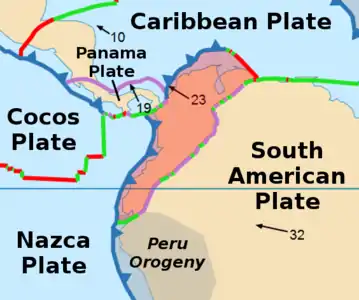
The North Andes Plate or North Andes Block is a small tectonic plate (microplate) located in the northern Andes. It is squeezed between the faster moving South American Plate and the Nazca Plate to the southwest. Due to the subduction of the Malpelo and Coiba Plates, this area is very prone to volcanic and seismic activity, with many historic earthquakes.
| North Andes Plate | |
|---|---|
 North Andes Plate (note: outdated Nazca Plate) | |
| Type | Minor |
| Movement1 | north-west |
| Speed1 | 23mm/year |
| Features | |
| 1Relative to the African Plate | |
Boundaries
The North Andes Plate is bound by (clockwise from north):
- Caribbean Plate
- South American Plate
- Malpelo Plate (before 2017 considered part of Nazca Plate)[1]
- Coiba Plate (before 2016 considered part of Nazca Plate)[2]
- Panama Plate
Terranes
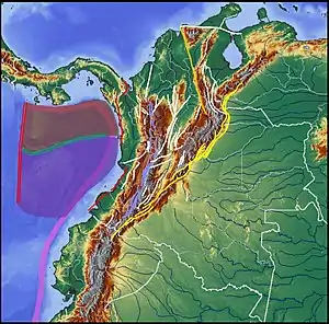
• Tahamí Terrane is enclosed by BSF, OCA and RFS
• Anacona, Arqúia and Quebradagrande Terranes are emplaced by RFS
• La Guajira Terrane is enclosed by BSF and northernmost by Oca
• Caribe Terrane is enclosed by BSF, RFS and plate boundaries with Coiba (red) and Malpelo Plates (purple)
The Colombian part of the North Andes Plate is subdivided into several terranes:[3]
Tectonics
Subduction of the Coiba Plate underneath the North Andes Plate causes frequent earthquakes in the Bucaramanga Nest, the most seismically active area in the world. The Bucaramanga-Santa Marta Fault stretches along the plate for more than 600 kilometers from north to south. The plate boundary with the South American Plate is most tectonically active along a more than 900 kilometer long megaregional fault system; the Eastern Frontal Fault System.
This fault system, extending into Ecuador and Venezuela all along the northern Andes, separates the terranes from the North Andes Plate from:[3]
| Abbr | Name | Age range | Basins | Complexes | Ranges | Departments | Comments | Notes |
|---|---|---|---|---|---|---|---|---|
| PRNJ | Río Negro-Juruena Province | Paleoproterozoic | • Llanos • Putumayo • Amazonas | Mitú, Parguaza, Guaviare | Chiribiquete, Mavecure | Arauca, Caquetá, Casanare, Guainía, Guaviare, Meta, Putumayo, Vaupés, Vichada | Part of Amazonian Craton | [14][15] |
References
- Zhang et al., 2017
- Chiarabba et al., 2016, p.22
- Gómez Tapias et al., 2015, p.209
- Manosalva Sánchez et al., 2017, p.84
- Mantilla Figueroa et al., 2015, p.42
- Toro Toro et al., 2014, p.22
- Plancha 364
- Plancha 365
- Plancha 387
- Plancha 410
- Plancha 411
- Plancha 429
- Plancha 430
- Bonilla et al., 2016, p.19
- Arango Mejía et al., 2012, p.25
Bibliography
- Manosalva Sánchez, Sandra Rocío; Wilson Enario Naranjo Merchán; Carlos Alberto Ríos Reyes; Ricardo Amorocho Parra, and Oscar Mauricio Castellanos Alarcón. 2017. Estudio petrogenetico de las rocas metamorficas del Macizo de Floresta, Cordillera Oriental, Andes Colombianos. Boletín de Geología 39. 83–103. Accessed 2019-10-26.
- Zhang, Tuo; Richard G. Gordon; Jay K. Mishra, and Chengzu Wang. 2017. The Malpelo Plate Hypothesis and implications for nonclosure of the Cocos-Nazca-Pacific plate motion circuit, 1. AGU Fall Meeting, New Orleans. Accessed 2018-06-06.
- Bonilla, Amed; José Carlos Frantz; Juliana Charão Marques; Thomas Cramer; José Alejandro Franco, and Zeze Amaya. 2016. Magmatismo rapakivi en la cuenca media del río Inírida, departamento de Guainía, Colombia. Boletín de Geología 38. 17–32. Accessed 2019-10-26.
- Chiarabba, Claudio; Pasquale De Gori; Claudio Faccenna; Fabio Speranza; Danilo Seccia; Viviana Dionicio, and German A. Prieto. 2016. Subduction system and flat slab beneath the Eastern Cordillera of Colombia. Geochemistry, Geophysics, Geosystems 17. 16–27. Accessed 2018-06-06.
- Gómez Tapias, Jorge; Nohora E. Montes Ramírez; María F. Almanza Meléndez; Fernando A. Alcárcel Gutiérrez; César A. Madrid Montoya, and Hans Diederix. 2015. Geological Map of Colombia, 1–212. Servicio Geológico Colombiano. Accessed 2019-10-29.
- Parra, Felipe de la; Andrés Mora; Milton Rueda, and Isaid Quintero. 2015. Temporal and spatial distribution of tectonic events as deduced from reworked palynomorphs in the eastern Northern Andes. AAPG Bulletin 99. 1455–1472.
- Egbue, Obi; James Kellogg; Hector Aguirre, and Carolina Torres. 2014. Evolution of the stress and strain fields in the Eastern Cordillera, Colombia. Journal of Structural Geology 58. 8–21.
- Perico Martínez, Néstor Rafael, and Néstor Rafael Perico Granados. 2014. Caracterización y recurrencia sísmica del Nido de Bucaramanga, 1–19. V Congreso Internacional de Ingeniería Civil, Universidad Santo Tomás Seccional Tunja.
- Toro Toro, Luz Mary; Mario Moreno Sánchez, and Arley Gómez Cruz. 2014. Metagabro del Ariari, Plutonismo MORB, Cordillera Oriental de Colombia. Boletín de Geología 36. 15–24. Accessed 2019-10-26.
- Yarce, Jefferson; Gaspar Monsalve; Thorsten W. Becker; Agustín Cardona; Esteban Poveda; Daniel Alvira, and Oswaldo Ordoñez Carmona. 2014. Seismological observations in Northwestern South America: Evidence for two subduction segments, contrasting crustal thicknesses and upper mantle flow. Tectonophysics 637. 57–67.
- Jiménez Díaz, Giovanny. 2013. Relationship between curved thrust belts, rift inversion, oblique convergence and strike-slip faulting - an example of Eastern Cordillera in Colombia (PhD thesis), 1–106. Università di Roma.
- Arango Mejía, María Isabel; Gilberto Zapata García, and Uwe Martens. 2012. Caracterización petrográfica, geoquímica y edad de la Sienita Nefelínica de San José del Guaviare. Boletín de Geología 34. 15–26. Accessed 2019-10-26.
- Cuéllar Cárdenas, Mario Andrés; Julián Andrés López Isaza; Jairo Alonso Osorio Naranjo, and Edgar Joaquín Carrillo Lombana. 2012. Análisis estructural del segmento Bucaramanga del Sistema de Fallas de Bucaramanga (SFB) entre los municipios de Pailitas y Curumaní, Cesar - Colombia. Boletín de Geología, Universidad Industrial de Santander 34. 73–101. Accessed 2017-06-20.
- Sánchez, Javier; Brian K. Horton; Eliseo Tesón; Andrés Mora; Richard A. Ketcham, and Daniel F. Stockli. 2012. Kinematic evolution of Andean fold-thrust structures along the boundary between the Eastern Cordillera and Middle Magdalena Valley basin, Colombia. Tectonics 31. 1–24. Accessed 2017-06-20.
- Diederix, Hans; Catalina Hernández M.; Eliana Torres J.; Jairo Alonso Osorio, and Paola Botero. 2009. Resultados preliminares del primer estudio paleosismológico a lo largo de la Falla de Bucaramanga, Colombia. Ingeniería, Investigación y Desarrollo, UPTC 9. 18–23. Accessed 2017-06-20.
- García González, Mario; Ricardo Mier Umaña; Luis Enrique Cruz Guevara, and Mauricio Vásquez. 2009. Informe Ejecutivo - evaluación del potencial hidrocarburífero de las cuencas colombianas, 1–219. Universidad Industrial de Santander.
- Parra, Mauricio; Andrés Mora; Edward R. Sobel; Manfred R. Strecker; Carlos Jaramillo; Paul B. O'Sullivan, and Román González. 2008. Cenozoic Orogenic Growth of the North Andes: Shortening and Exhumation Histories of the Eastern Cordillera of Colombia, 1–27. AAPG Annual Convention, San Antonio, Texas.
- Barrero, Dario; Andrés Pardo; Carlos A. Vargas, and Juan F. Martínez. 2007. Colombian Sedimentary Basins: Nomenclature, Boundaries and Petroleum Geology, a New Proposal, 1–92. ANH.
- Sarmiento Rojas, L.F.; J.D. Van Wees, and S. Cloetingh. 2006. Mesozoic transtensional basin history of the Eastern Cordillera, Colombian Andes: Inferences from tectonic models. Journal of South American Earth Sciences 21. 383–411. Accessed 2016-11-17.
- Cediel, Fabio; Robert P. Shaw, and Carlos Cáceres. 2003. Tectonic Assembly of the Northern Andean Block - The Circum-Gulf of Mexico and the Caribbean: Hydrocarbon habitats, basin formation, and plate tectonics. AAPG Memoir 79. 815–848.
- Colmenares, Lourdes, and Mark D. Zoback. 2003. Stress field and seismotectonics of northern South America. Geology 31. 721–724.
- Nevistic, A.V.; E.A. Rossello; C.E. Haring; G. Covellone; F. Bettini; H. Rodríguez; R. Salay; C. Colo, and L. Araque, E. Castro, C. Pinilla, C.P. Bordarampé. 2003. The Andean Santander-Oriental Tectonic Syntaxis: A first-order pattern controlling exploration play-model concepts in Colombia, 130–134. VIII Simposio Bolivariano - Exploración Petrolera en las Cuencas Subandinas.
- Paris, Gabriel; Michael N. Machette; Richard L. Dart, and Kathleen M. Haller. 2000. Map and Database of Quaternary Faults and Folds in Colombia and its Offshore Regions, 1–66. USGS. Accessed 2017-06-20.
Maps
- González, Humberto. 2001. Mapa Geológico del Departamento de Antioquia - 1:400,000 - Memoria explicativa, 1–120. INGEOMINAS.
- Montoya Arenas, Diana María, and Germán Alfonso Reyes Torres. 2005. Geología de la Sabana de Bogotá, 1–104. INGEOMINAS.
- Royero Gutiérrez, Jose María, and Jairo Clavijo Torres. 2000. Mapa geológico generalizado del Departamento de Bolívar - 1:400,000 - Memoria explicativa, 1–99. INGEOMINAS. Accessed 2017-08-31.
- Rodríguez Parra, Antonio José, and Orlando Solano Silva. 2000. Mapa Geológico del Departamento de Boyacá - 1:250,000 - Memoria explicativa, 1–120. INGEOMINAS. Accessed 2019-03-10.
- Acosta, Jorge E., and Carlos E. Ulloa. 2002. Mapa geológico del Departamento de Cundinamarca 1:250,000 - Memoria Explicativa, 1–108. INGEOMINAS.
- Rodríguez, Gabriel, and Ana Cristina Londoño. 2002. Mapa geológico del Departamento de La Guajira - 1:250,000, 1–259. INGEOMINAS. Accessed 2017-08-08.
- Royero Gutiérrez, José María, and Jairo Clavijo. 2001. Mapa geológico del Departamento de Santander 1:400,000 - Memoria Explicativa, 1–92. INGEOMINAS.
- Acosta Garay, Jorge, and Carlos E. Ulloa Melo. 2001. Geología de la Plancha 208 Villeta - 1:100,000, 1–84. INGEOMINAS. Accessed 2017-03-16.
- Terraza, Roberto; Diana Montoya; Germán Reyes; Giovanni Moreno; Jaime Fúquen; Eliana Torres Jaimes; Myriam López Cardona; Álvaro Nivia Guevara, and Fernando Etayo Serna. 2013. Geología de la Plancha 229 - Gachalá - 1:100,000, 1–296. Servicio Geológico Colombiano. Accessed 2017-08-04.
- Patiño, Alejandro; Jaime Fuquen; Julián Ramos; Andrea Pedraza; Leonardo Ceballos; Lyda Pinzón; Yadira Jerónimo; Leidy Álvarez, and Andrea Torres. 2011. Cartografía geológica de la Plancha 247 - Cáqueza - 1:100,000, . INGEOMINAS. Accessed 2017-08-04.
- Guerrero Uscátegui, Alberto Lobo. 1992. Geología e Hidrogeología de Santafé de Bogotá y su Sabana, 1–20. Sociedad Colombiana de Ingenieros.
- Orrego, Abigail; Luis León; Luis Eduardo Padilla; Álvaro Pablo Acevedo, and Nelson Marulanda. 1999. Plancha 364 - Timbío - 1:100,000, 1. INGEOMINAS. Accessed 2017-06-06.
- Marquínez, Germán; Yohana Rodríguez; Roberto Terraza, and Mario Martínez. 2003. Plancha 365 - Coconuco - 1:100,000, 1. INGEOMINAS. Accessed 2017-06-06.
- Orrego, Abigail; Gabriel Paris; Diego Ibañez, and Edgar Vásquez. 1999. Plancha 387 - Bolívar - 1:100,000, 1. INGEOMINAS. Accessed 2018-06-01.
- Murcia L., Armando, and Hector Cepeda V. 1991. Plancha 410 - La Unión - 1:100,000, 1. INGEOMINAS. Accessed 2018-06-01.
- Núñez, Alberto, and Jorge Gómez. 2002. Plancha 411 - La Cruz - 1:100,000, 1. INGEOMINAS. Accessed 2017-06-06.
- Murcia L., Armando, and Hector Cepeda V. 1991. Plancha 429 - Pasto - 1:100,000, 1. INGEOMINAS. Accessed 2018-06-01.
- Núñez, Alberto, and Jorge Gómez. 2002. Plancha 430 - Mocoa - 1:100,000, 1. INGEOMINAS. Accessed 2017-06-06.
Further reading
- Bird, P. (2003) An updated digital model of plate boundaries, Geochemistry Geophysics Geosystems, 4(3), 1027, doi:10.1029/2001GC000252.
| Tectonic plates | 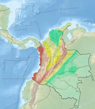 | ||||||||||
|---|---|---|---|---|---|---|---|---|---|---|---|
| Terranes |
| ||||||||||
| Terrane-bounding fault systems |
| ||||||||||
| Intraterrane faults |
| ||||||||||
| Major earthquakes | |||||||||||
| Orogenies |
| ||||||||||
| Other topics | |||||||||||
| Sources |
| ||||||||||