Apachita (Potosí)
Apachita (Aymara for the place of transit of an important pass in the principal routes of the Andes; name for a stone cairn in the Andes, a little pile of rocks built along the trail in the high mountains,[1][2] also spelled Apacheta) is a mountain in the Cordillera Occidental in the Bolivian Andes. It is located in the Potosí Department, Sur Lípez Province, San Pablo de Lípez Municipality, near the Chilean border.[3][4] Apachita lies within the borders of the Eduardo Avaroa Andean Fauna National Reserve.[5] It is situated east of Michina.[3]
| Apachita | |
|---|---|
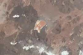 Laguna Colorada and Apachita (lower right) as seen from the ISS (North is to the upper left part of this image.) | |
| Highest point | |
| Coordinates | 22°26′39″S 67°47′28″W |
| Geography | |
 Apachita Location in Bolivia | |
| Location | Bolivia, Potosí Department, Sur Lípez Province |
| Parent range | Andes, Cordillera Occidental |
References
- http://www.illa-a.org/cd/diccionarios/DicAymaraMinEduPeru.odt (Aymara-Spanish dictionary)
- Teofilo Laime Ajacopa, Diccionario Bilingüe Iskay simipi yuyayk'ancha, La Paz, 2007 (Quechua-Spanish dictionary)
- Bolivian IGM map 1:250,000 Volcán Juriques SF-19-11
- "San Pablo de Lípez". INE, Bolivia. Archived from the original on January 28, 2016. Retrieved October 11, 2014.
- sernap.gob.bo Reserva National de Fauna Andina Eduardo Avaroa
Capital: Potosí | ||
| Provinces |  | |
| Municipalities (and seats) |
| |
This article is issued from Wikipedia. The text is licensed under Creative Commons - Attribution - Sharealike. Additional terms may apply for the media files.