Applewood, Colorado
Applewood is an unincorporated community and a census-designated place (CDP) located in Jefferson County, Colorado, United States. The population of the Applewood CDP was 7,160 at the United States Census 2010.[4] Jefferson County governs the unincorporated community. The Golden post office (Zip code 80401) serves the area.[3]
Applewood, Colorado | |
|---|---|
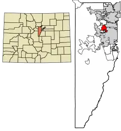 Location of the Applewood CDP in Jefferson County, Colorado. | |
 Applewood Location of the Applewood CDP in the United States. | |
| Coordinates: 39°45′09″N 105°09′38″W[1] | |
| Country | |
| State | |
| County | Jefferson County |
| Government | |
| • Type | unincorporated community |
| Area | |
| • Total | 4.486 sq mi (11.619 km2) |
| • Land | 4.064 sq mi (10.527 km2) |
| • Water | 0.422 sq mi (1.092 km2) |
| Elevation | 5,810 ft (1,771 m) |
| Population (2010) | |
| • Total | 7,160 |
| • Density | 1,762/sq mi (680/km2) |
| Time zone | UTC-7 (MST) |
| • Summer (DST) | UTC-6 (MDT) |
| ZIP Code[3] | Golden 80401 |
| Area codes | 303 & 720 |
| GNIS feature[2] | Applewood CDP |
Geography
Applewood is 10 miles (16 km) west of downtown Denver. It is bordered to the north by Fairmount, to the northeast by Wheat Ridge, to the southeast by Lakewood, and to the southwest by West Pleasant View. South Table Mountain borders Applewood to the west.
The Applewood CDP has an area of 2,871 acres (11.619 km2) including 270 acres (1.092 km2) of water.[1]
Demographics
The United States Census Bureau initially defined the Applewood CDP for the 1970 United States Census.
| Year | Pop. | ±% |
|---|---|---|
| 1970 | 8,214 | — |
| 1980 | 12,040 | +46.6% |
| 1990 | 11,069 | −8.1% |
| 2000 | 7,123 | −35.6% |
| 2010 | 7,160 | +0.5% |
| 2020 | — | |
| Source: United States Census Bureau | ||
Education
Applewood is served by the Jefferson County School District R-1.
See also
- Colorado
- Outline of Colorado
- List of cities and towns in Colorado
- List of counties in Colorado
- Colorado statistical areas
References
- "State of Colorado Census Designated Places - BAS20 - Data as of January 1, 2020". United States Census Bureau. Retrieved December 2, 2020.
- "U.S. Board on Geographic Names: Domestic Names". United States Geological Survey. Retrieved December 2, 2020.
- "Zip Code 80401 Map and Profile". zipdatamaps.com. 2020. Retrieved December 20, 2020.
- "2010: DEC Summary File 1". United States Census Bureau. Retrieved December 20, 2020.
External links
- Applewood Valley Association (AVA)
- Applewood Business Association
- Prospect Recreation & Park District
- Jefferson County website
- Jeffco Public Schools
Municipalities and communities of Jefferson County, Colorado, United States | ||
|---|---|---|
| Cities | 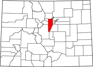 Map of Colorado highlighting Jefferson County | |
| Towns | ||
| CDPs | ||
| Unincorporated communities | ||
| Ghost town | ||
| Footnotes | ‡This populated place also has portions in an adjacent county or counties | |
| ||