Lakewood, Colorado
The City of Lakewood is the Home Rule Municipality that is the most-populous municipality in Jefferson County, Colorado, United States. Lakewood is the fifth-most populous city in Colorado and the 172nd-most populous city in the United States. The city population was 142,980 at the 2010 United States Census. Lakewood lies immediately west of Denver and is one of the principle cities of the Denver–Aurora–Lakewood, CO Metropolitan Statistical Area and a major city of the Front Range Urban Corridor.
Lakewood, Colorado | |
|---|---|
Home Rule Municipality[1] | |
| City of Lakewood[1] | |
.jpg.webp) Green Mountain as seen from Mt. Zion. | |
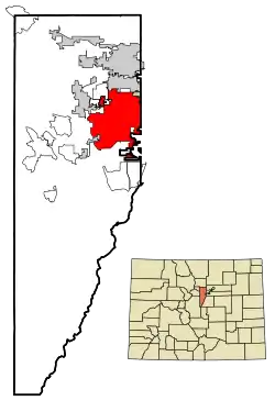 Location of the City of Lakewood in Jefferson County, Colorado. | |
 Lakewood Location of the City of Lakewood in the United States. | |
| Coordinates: 39°42′17″N 105°04′53″W | |
| Country | |
| State | |
| County | Jefferson County[2] |
| City | Lakewood[1] |
| Founded | 1889 |
| Incorporated | 1969[3] |
| Government | |
| • Type | Home Rule Municipality[1] |
| • Mayor | Adam Paul |
| Area | |
| • Home Rule Municipality[1] | 44.22 sq mi (114.53 km2) |
| • Land | 43.05 sq mi (111.49 km2) |
| • Water | 1.17 sq mi (3.04 km2) |
| Elevation | 5,518 ft (1,682 m) |
| Population | |
| • Home Rule Municipality[1] | 142,980 |
| • Estimate (2019)[7] | 157,935 |
| • Rank | US: 169th |
| • Density | 3,668.90/sq mi (1,416.58/km2) |
| • Metro | 2,814,330 (US: 19th) |
| Time zone | UTC−7 (MST) |
| • Summer (DST) | UTC−6 (MDT) |
| ZIP codes | Denver 80214-80215, 80227, 80226-80228, 80232, 80235-80236 Golden 80401 Littleton 80123 |
| Area code(s) | Both 303 and 720 |
| FIPS code | 08-43000 |
| GNIS feature ID | 0181620 |
| Highways | I-70, US 6, US 40, US 285, SH 8, SH 95, SH 121, SH 391, SH 470 |
| Website | City of Lakewood |
History
The urban and suburban development of the community known as Lakewood was started in 1889 by Charles Welch and W.A.H. Loveland, who platted a 13-block area along Colfax Avenue west of Denver in eastern Jefferson County. Loveland, the former president of the Colorado Central Railroad, retired to the new community of Lakewood after many years of living in Golden.
Until 1969, the area known as Lakewood had no municipal government, relying instead on several water districts, several fire districts, and the government of Jefferson County. Lakewood was a community with policing provided by the Jefferson County Sheriff, several volunteer-staffed fire districts, and some neighborhoods without street lights or sidewalks. However, the community had already existed for about 80 years.
The City of Lakewood was incorporated in 1969 as Jefferson City. Soon after, an election was held and the city's name was changed to Lakewood, due to an overwhelming dislike of "Jefferson City" and the belief that it would be confused with existing communities in Colorado and Missouri.[8] At the time of incorporation, the city population was already over 90,000.
Lakewood never had a traditional downtown area. West Colfax Avenue served the metropolitan area as U.S. Route 40 and the main route joining Denver with the Rocky Mountains. As such, Colfax from Harlan west to Kipling and beyond had mostly commercial establishments. In addition to the Jewish Consumptive Relief Society (JCRS) for tuberculosis patients, the small, frame Methodist Church, and telephone exchange, by the 1950s grocery and drug stores, gas stations, restaurants and taverns, several motels, branch banks, a movie theater, a roller rink, a bowling alley, and used car lots emerged there. Several multiple-business "shopping centers" developed followed by much larger centers at JCRS and Westland. The Villa Italia Mall on West Alameda Avenue, 20 blocks south of Colfax, reflected the southward expansion of Lakewood settlement and housed a larger concentration of retail space. As the mall went into decline, the Lakewood City Council developed a plan to demolish the Villa Italia Mall and replace it with a new development called Belmar.[9]
In 2011, Lakewood was named an All-America City for the first time.
Geography
Lakewood is located at 39°42′17″N 105°04′53″W at an elevation of 5,518 feet (1,682 m).[5] Located at the junction of U.S. Route 6 and Colorado State Highway 121 in central Colorado, the city lies immediately west of Denver and 62 miles (100 km) north-northwest of Colorado Springs.[10][11]
Lakewood lies in the Colorado Piedmont on the western edge of the Great Plains just east of the Front Range of the southern Rocky Mountains.[10][12][13] Green Mountain, a mesa 6,854 feet (2,089 m) tall, is located in the far west-central part of the city.[10]
The city is located in the watershed of the South Platte River, and several small tributaries of the river flow generally east through it. From north to south, these include Lakewood Gulch, Weir Gulch, Sanderson Gulch, and Bear Creek. Two tributaries of Lakewood Gulch, Dry Gulch and McIntyre Gulch, flow east through the northern part of the city. Turkey Creek, a tributary of Bear Creek, flows northeast through the far southwestern part of the city. In addition, Lena Gulch, a tributary of Clear Creek to the north, flows east then north through the extreme northwestern part of the city.[10]
Several small lakes and reservoirs are in Lakewood. The Soda Lakes lie in the extreme southwestern part of the city. East of them lies Bear Creek Lake, a reservoir fed by Bear Creek and Turkey Creek. Clustered near each other in central Lakewood are Main Reservoir, East Reservoir, Smith Reservoir, Kendrick Lake, and Cottonwood Lake. Northeast of them lies Kountze Lake. In the northwestern part of the city, Lena Gulch both feeds and drains Maple Grove Reservoir. In the extreme southern part of the city lies Bowles Reservoir No. 1 and, just outside the city limits to the reservoir's northeast, Marston Lake.[10]
According to the United States Census Bureau, the city has a total area of 44.06 square miles (114.1 km2) of which 42.88 sq mi (111.1 km2) are land and 1.18 sq mi (3.1 km2) (2.7%) are covered by water.[14]
As a suburb of Denver, Lakewood is part of both the greater Denver metropolitan area and the Front Range Urban Corridor.[15] It borders other communities on all sides, including Wheat Ridge to the north, Edgewater to the northeast, Denver to the east and southeast, Dakota Ridge to the south, Morrison to the southwest, and Golden, West Pleasant View, East Pleasant View, and Applewood to the northwest.[14]
Climate
Lakewood experiences a semiarid climate (Köppen BSk) featuring winters fluctuating between mild to cold and snowy while summers are warm to hot, with great temperature differences (about 30°F) between day and night year round. Precipitation is concentrated in the spring and summer.
| Climate data for Lakewood, Colorado | |||||||||||||
|---|---|---|---|---|---|---|---|---|---|---|---|---|---|
| Month | Jan | Feb | Mar | Apr | May | Jun | Jul | Aug | Sep | Oct | Nov | Dec | Year |
| Record high °F (°C) | 72 (22) |
74 (23) |
84 (29) |
86 (30) |
94 (34) |
104 (40) |
101 (38) |
100 (38) |
96 (36) |
89 (32) |
88 (31) |
74 (23) |
104 (40) |
| Average high °F (°C) | 48.2 (9.0) |
49.0 (9.4) |
55.7 (13.2) |
62.5 (16.9) |
72.0 (22.2) |
82.2 (27.9) |
89.2 (31.8) |
86.7 (30.4) |
78.9 (26.1) |
66.9 (19.4) |
55.2 (12.9) |
47.1 (8.4) |
66.2 (19.0) |
| Average low °F (°C) | 18.9 (−7.3) |
19.9 (−6.7) |
26.7 (−2.9) |
34.3 (1.3) |
43.1 (6.2) |
52.2 (11.2) |
58.8 (14.9) |
56.8 (13.8) |
47.0 (8.3) |
35.5 (1.9) |
25.6 (−3.6) |
18.0 (−7.8) |
36.5 (2.5) |
| Record low °F (°C) | −26 (−32) |
−23 (−31) |
−11 (−24) |
−1 (−18) |
12 (−11) |
27 (−3) |
37 (3) |
41 (5) |
16 (−9) |
5 (−15) |
−5 (−21) |
−25 (−32) |
−26 (−32) |
| Average precipitation inches (mm) | 0.51 (13) |
0.51 (13) |
1.53 (39) |
2.22 (56) |
2.45 (62) |
2.40 (61) |
1.75 (44) |
1.95 (50) |
1.20 (30) |
1.18 (30) |
0.95 (24) |
0.65 (17) |
17.3 (439) |
| Average snowfall inches (cm) | 8.6 (22) |
6.7 (17) |
11.9 (30) |
10.0 (25) |
1.3 (3.3) |
0 (0) |
0 (0) |
0 (0) |
0.9 (2.3) |
3.3 (8.4) |
12.1 (31) |
8.7 (22) |
63.5 (161) |
| Source: [16] | |||||||||||||
Demographics
| Historical population | |||
|---|---|---|---|
| Census | Pop. | %± | |
| 1960 | 19,338 | — | |
| 1970 | 92,743 | 379.6% | |
| 1980 | 113,808 | 22.7% | |
| 1990 | 126,481 | 11.1% | |
| 2000 | 144,126 | 14.0% | |
| 2010 | 142,980 | −0.8% | |
| 2019 (est.) | 157,935 | [7] | 10.5% |
| U.S. Decennial Census[17] | |||
As of the 2010 census, 142,980 people, 61,986 households, and 35,882 families were residing in the city. The population density was 3,334.4 people per square mile (1,286.9/km2). Its 65,758 housing units averaged 1,533.5 per square mile (591.9/km2). The racial makeup of the city was 82.9% White, 3.1% Asian, 1.6% Black, 1.4% American Indian, 0.1% Pacific Islander, 7.7% from other races, and 3.3% from two or more races. Hispanics and Latinos of any race were 22.0% of the population.[18]
Of the 61,986 households, 26.8% had children under the age of 18 living with them, 41.1% were married couples living together, 5.0% had a male householder with no wife present, 11.9% had a female householder with no husband present, and 42.1% were not families. About 33.5% of all households were made up of individuals, and 10.2% had someone living alone who was 65 years of age or older. The average household size was 2.27, and the average family size was 2.92.[18]
The distribution of the population by age was 20.8% under the age of 18, 9.6% from 18 to 24, 27.1% from 25 to 44, 28.0% from 45 to 64, and 14.5% who were 65 years of age or older. The median age was 39.2 years. The gender makeup of the city was 48.9% male and 51.1% female.[18]
The median income for a household in the city was $52,960, and for a family was $66,947. Males had a median income of $46,907 versus $41,476 for females. The city's per capita income was $30,027. About 9.1% of families and 11.7% of the population were below the poverty line, including 20.3% of those under age 18 and 6.1% of those age 65 or over.[18]
Economy
Lakewood's economy is diverse, while the largest employers are government. Companies based in Lakewood include Einstein Bros. Bagels, FirstBank, and The Integer Group.
As of 2013, 67.3% of the population over the age of 16 was in the labor force. 0.1% was in the armed forces, and 67.3% was in the civilian labor force with 61.1% employed and 6.2% unemployed. The occupational composition of the employed civilian labor force was 38.6% in management, business, science, and arts; 25.9% in sales and office occupations; 16.9% in service occupations; 9.9% in production, transportation, and material moving; and 8.7% in natural resources, construction, and maintenance. The three industries employing the largest percentages of the working civilian labor force were educational services, health care, and social assistance (18.4%); professional, scientific, and management, and administrative and waste management services (13.8%); and retail trade (11.9%).[18]
The cost of living index in Lakewood, compared to a U.S. average of 100, is 107.4.[19] As of 2013, the median home value in the city was $238,500, the median selected monthly owner cost was $1,546 for housing units with a mortgage and $442 for those without, and the median gross rent was $940.[18]
Top employers
According to the City's 2017 Comprehensive Annual Financial Report, the top employers in the city are:[20]
| # | Employer | # of Employees |
|---|---|---|
| 1 | Denver Federal Center | 8,000 |
| 2 | Jefferson County Public Schools | 4,010 |
| 3 | Terumo BCT | 2,320 |
| 4 | St. Anthony Hospital | 2,200 |
| 5 | First Bank | 1,261 |
| 6 | State of Colorado | 1,084 |
| 7 | HomeAdvisor | 1,070 |
| 8 | City of Lakewood | 900 |
| 9 | The Integer Group | 435 |
| 10 | Colorado Christian University | 431 |
Government
Lakewood maintains a council/manager form of government. Citizens elect a city council consisting of the mayor, who is elected at-large, and 10 city council members, two from each of the city's five geographical wards. The mayor and the council members assert the policies for the operation of the city government.
As of 2020, the mayor is Adam Paul. The council members representing the first ward are Ramey Johnson and Charley Able, Jacob LaBure and Sharon Vincent represent the second ward, Anita Springsteen and Mike Bieda represent the third ward, David Skilling and Barb Franks represent the fourth ward, and the fifth ward is represented by Karen Harrison and Dana Gutwein.
The City of Lakewood falls into Colorado House District 26, parts of House District 24, and House District 23. Lakewood is represented in the state house by Reps. Chris Kennedy, Kerry Tipper, and Monica Duran.[21]
Education
Lakewood also houses Lakewood High School, Green Mountain High School, Bear Creek High School, Brady Exploration High School, Alameda International High School, and International Baccalaureate schools in Jefferson County. Lakewood is also home to Colorado Christian University and Colorado School of Trades.
The town is served by the Jefferson County Public Library.
Transportation
Transportation within the city, and to other areas in the metropolitan area, is provided by RTD. RTD's Light Rail W line runs directly through Lakewood. Intercity transportation is provided by Bustang. Lakewood is along Bustang's West Line, which connects Denver to Grand Junction.[22]
Points of interest
Landmarks and historical points of interest include:
- The old Villa Italia Mall has been replaced by Belmar, a new town center with a mix of retail, residential, cultural, and public space. The Laboratory of Art and Ideas at Belmar was located in Belmar until May 2009, and that location is now occupied by the Colorado Campus of the Ohio Center for Broadcasting, a private trade school for the radio and television industry. Belmar has a designated Arts District that houses a number of artist studios and several gallery spaces, and a nonprofit fine-art photography school called Working with Artists.
- Casa Bonita, a local Mexican restaurant in Lakewood, is where a South Park episode took place.
- Lakewood Cultural Center features a theater, gallery space, and art classrooms.
- Heritage Lakewood Belmar Park is a 20th-century museum and festival grounds, with several historic buildings, and is located near Kountze Lake, which formerly housed the Belmar Mansion.
- Reed Art & Imaging at 8000 West Colfax Avenue is housed in what was originally the Lakewood movie theater dating from the early 1950s.
- At William Fredrick Hayden Park in the foothills of Green Mountain, the Colorado National Guard used the north side for artillery practice. The Department of Defense Military Munitions Response Program has financed investigations to identify unexploded ordnance there since 2012.[23]
- Lakewood has a shopping mall called Colorado Mills, which is near I-70 and West Colfax Avenue.
- Lakewood is home to the 40 West Arts District, which includes a bike and walking art experience along the light rail.[24]
Notable people
Notable individuals who were born in or have lived in Lakewood include geospatial software pioneer Sol Katz,[25] guitarist Chris Broderick,[26] professional wrestler "Dr. Death" Steve Williams,[27] and Colorado heiress and philanthropist May Bonfils Stanton, portions of whose 750-acre (300 ha) estate, Belmar, were used in the creation of the Belmar residential neighborhood and the Lakewood downtown district.[28][29]
Sister cities
Lakewood has four sister cities, as designated by Sister Cities International:
 Chester, Cheshire, United Kingdom
- Portsmouth, Hampshire, United Kingdom, also a Friendship City
 Stade, Lower Saxony, Germany[30]
.svg.png.webp) Sutherland Shire, Sydney, New South Wales, Australia
Sutherland Shire, Sydney, New South Wales, Australia
See also
- Outline of Colorado
- State of Colorado
- Colorado cities and towns
- Colorado municipalities
- Colorado counties
- Colorado metropolitan areas
- Colorado cities and towns
References
- "Active Colorado Municipalities". State of Colorado, Colorado Department of Local Affairs, Division of Local Government. Retrieved January 27, 2021.
- "Colorado Counties". State of Colorado, Colorado Department of Local Affairs, Division of Local Government. Retrieved January 27, 2021.
- "Colorado Municipal Incorporations". State of Colorado, Department of Personnel & Administration, Colorado State Archives. 2004-12-01. Retrieved 2007-09-02.
- "2019 U.S. Gazetteer Files". United States Census Bureau. Retrieved July 1, 2020.
- "US Board on Geographic Names". United States Geological Survey. 2007-10-25. Retrieved 2015-03-04.
- "U.S. Census website". United States Census Bureau. Retrieved June 29, 2015.
- "Population and Housing Unit Estimates". Retrieved May 21, 2020.
- Standish, LeRoy. "Lakewood's come a long way". Colorado Community Media.
- The Christian Science Monitor (22 May 2009). "After the mall: Retrofitting suburbia". The Christian Science Monitor.
- "Lakewood, CO". Google Maps. Retrieved 2015-03-04.
- "Distance Calculator". Infoplease. Retrieved 2015-03-04.
- "Physiographic Provinces of Colorado [Map]". Colorado Geological Survey. Retrieved 2015-03-04.
- "General Map of Colorado". Colorado Life Zones. Archived from the original on 2016-03-03. Retrieved 2015-03-04.
- "Colorado: 2010 - Population and Housing Unit Counts" (PDF). United States Census Bureau. August 2012. Retrieved 2015-03-04.
- "OMB Bulletin No. 13-01" (PDF). Office of Management and Budget. 2013-02-28. Archived from the original (PDF) on 2017-01-18. Retrieved 2015-03-04.
- https://wrcc.dri.edu/cgi-bin/cliMAIN.pl?colwoo Retrieved 10 August 2020.
- "Census of Population and Housing". Census.gov. Retrieved June 4, 2015.
- "U.S. Census website". United States Census Bureau. Retrieved 2015-03-04.
- "Lakewood, Colorado". City-Data.com. Retrieved 2015-03-09.
- "State House District 26". COMaps. Archived from the original on 2009-02-12. Retrieved 2009-01-21.
- "Bustang Schedules". RideBustang. CDOT.
- Austin Briggs (July 29, 2015). "Old explosives still being found at Lakewood's Green Mountain park". Denver Post. Digital First Media. Retrieved 31 July 2015.
- "ArtLine". www.40westartline.org. Retrieved 2020-02-05.
- "Sol Katz Award for Geospatial Free and Open Source Software". OSGeo. Archived from the original on 2016-04-06. Retrieved 2016-04-15.
- Marshall, Brandon (2012-02-22). "Chris Broderick of Megadeth: "There was definitely a metal scene in Denver back in 1988"". Westword. Retrieved 2016-04-15.
- Groke, Nick (2009-12-30). ""Dr. Death" Steve Williams, famed wrestler, dies in Denver". The Denver Post. Retrieved 2016-04-15.
- Varnell, Jeanne (1999). Women of Consequence: The Colorado Women's Hall of Fame. Big Earth Publishing. p. 93. ISBN 1555662145.
- Riley, Marilyn Griggs (2006). High Altitude Attitudes: Six Savvy Colorado Women. Big Earth Publishing. p. 64. ISBN 1555663753.
- Stade is located on the German Timber-Frame Road
External links
| Wikimedia Commons has media related to Lakewood, Colorado. |
- Official website
- CDOT map of the City of Lakewood
- Lakewood Heritage Center
- Colfax Avenue is Lakewood, Colorado's main street and is also a part of Historic Route 40.
Municipalities and communities of Jefferson County, Colorado, United States | ||
|---|---|---|
| Cities | 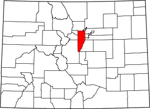 Map of Colorado highlighting Jefferson County | |
| Towns | ||
| CDPs | ||
| Unincorporated communities | ||
| Ghost town | ||
| Footnotes | ‡This populated place also has portions in an adjacent county or counties | |
| ||

Mayors of cities with populations exceeding 100,000 in Colorado | ||
|---|---|---|
| ||
| Authority control |
|---|