West Pleasant View, Colorado
West Pleasant View is an unincorporated community and a census-designated place (CDP) located in and governed by Jefferson County, Colorado, United States. The CDP is a part of the Denver–Aurora–Lakewood, CO Metropolitan Statistical Area. The population of the West Pleasant View CDP was 3,840 at the United States Census 2010.[4] The Pleasant View Metropolitan District provides services. The Golden post office (Zip code 80401) serves the area.[3]
West Pleasant View, Colorado | |
|---|---|
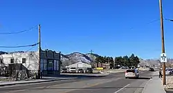 South Golden Road in West Pleasant View. | |
 Location of the West Pleasant View CDP in Jefferson County, Colorado. | |
 West Pleasant View Location of the West Pleasant View CDP in the United States. | |
| Coordinates: 39°43′55″N 105°10′42″W[1] | |
| Country | |
| State | |
| County | Jefferson County |
| Government | |
| • Type | unincorporated community |
| Area | |
| • Total | 1.543 sq mi (3.996 km2) |
| • Land | 1.543 sq mi (3.996 km2) |
| • Water | 0.000 sq mi (0.000 km2) |
| Elevation | 5,823 ft (1,775 m) |
| Population (2010) | |
| • Total | 3,840 |
| • Density | 2,489/sq mi (961/km2) |
| Time zone | UTC-7 (MST) |
| • Summer (DST) | UTC-6 (MDT) |
| ZIP Code[3] | Golden 80401 |
| Area codes | 303 & 720 |
| GNIS feature[2] | West Pleasant View CDP |
Geography
West Pleasant View is bordered to the west by Golden, to the east by Lakewood, and to the north by unincorporated Applewood. Interstate 70, U.S. Route 6, and U.S. Route 40 (West Colfax Avenue) all cross the community from west to east. Downtown Denver is 10 miles (16 km) to the east.
The West Pleasant View CDP has an area of 987 acres (3.996 km2), all land.[1]
Demographics
The United States Census Bureau initially defined the West Pleasant View CDP for the United States Census 2000.
| Year | Pop. | ±% |
|---|---|---|
| 2000 | 3,932 | — |
| 2010 | 3,840 | −2.3% |
| 2020 | — | |
| Source: United States Census Bureau | ||
Education
Colorado's second largest school district, the Jefferson County Public Schools, has its headquarters in West Pleasant View.[5][6]
Zoned schools include:[5]
- Elementary schools: Shelton and Welchester[7]
- Middle schools: Bell[8]
- Golden High School[9]
See also
- Outline of Colorado
- State of Colorado
- Colorado cities and towns
- Colorado counties
- Colorado metropolitan areas
References
- "State of Colorado Census Designated Places - BAS20 - Data as of January 1, 2020". United States Census Bureau. Retrieved December 18, 2020.
- "U.S. Board on Geographic Names: Domestic Names". United States Geological Survey. Retrieved December 18, 2020.
- "Zip Code 80401 Map and Profile". zipdatamaps.com. 2020. Retrieved December 20, 2020.
- "2010: DEC Summary File 1". United States Census Bureau. Retrieved December 20, 2020.
- "West Pleasant View Map" (PDF). U.S. Census Bureau. Retrieved 2020-03-29.
- "Contact Us." Jefferson County Public Schools. Retrieved on April 3, 2011. "1829 Denver West Drive #27 Golden, CO 80401 " - Despite the Golden address, the actual location is West Pleasant View CDP.
- "Elementary Schools". Jeffco Public Schools. Retrieved 2020-03-28. - Shelton detail and Welchester detail
- "Middle Schools". Jeffco Public Schools. Retrieved 2020-03-28. - Bell Middle detail
- "High Schools". Jeffco Public Schools. Retrieved 2020-03-28. - Golden High detail
External links
Municipalities and communities of Jefferson County, Colorado, United States | ||
|---|---|---|
| Cities | 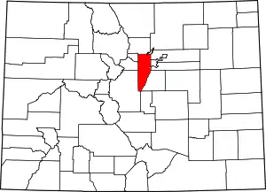 Map of Colorado highlighting Jefferson County | |
| Towns | ||
| CDPs | ||
| Unincorporated communities | ||
| Ghost town | ||
| Footnotes | ‡This populated place also has portions in an adjacent county or counties | |
| ||