Argens-Minervois
Argens-Minervois is a commune in the Aude department in the Occitanie region of southern France.
Argens-Minervois | |
|---|---|
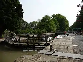 Lock on the Canal du Midi | |
.svg.png.webp) Coat of arms | |
Location of Argens-Minervois 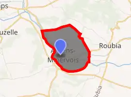
| |
 Argens-Minervois  Argens-Minervois | |
| Coordinates: 43°14′36″N 2°45′59″E | |
| Country | France |
| Region | Occitanie |
| Department | Aude |
| Arrondissement | Narbonne |
| Canton | Le Lézignanais |
| Intercommunality | CC Région Lézignanaise Corbières Minervois |
| Government | |
| • Mayor (2014-2020) | Gérard Garcia |
| Area 1 | 4.59 km2 (1.77 sq mi) |
| Population (2017-01-01)[1] | 347 |
| • Density | 76/km2 (200/sq mi) |
| Time zone | UTC+01:00 (CET) |
| • Summer (DST) | UTC+02:00 (CEST) |
| INSEE/Postal code | 11013 /11200 |
| Elevation | 27–120 m (89–394 ft) (avg. 39 m or 128 ft) |
| 1 French Land Register data, which excludes lakes, ponds, glaciers > 1 km2 (0.386 sq mi or 247 acres) and river estuaries. | |
The inhabitants of the commune are known as Argenais or Argenaises[2]
Geography
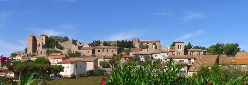
Argens-Minervois is located some 20 km west by south-west of Capestang and 6 km north of Lézignan-Corbières. The northern border of the commune is also the border between Aude and Hérault. Access to the commune is by the D124 road from Roubia in the east which passes through the village and continues along the bank of the Canal du Midi to join the D11 north-east of the commune. The commune is forested in the north with a large reservoir in the centre feeding the Canal du-Midi. The rest of the commune is farmland.[3]
The Aude river forms the whole southern and western border of the commune with the Canal du Midi parallel to it in the commune on the left bank in the commune. The large reservoir in the centre of the commune feeds the Canal through the Ruisseau de l'Étang on the eastern side and an unnamed stream on the western side. The Ruisseau du Four rises in the north-east of the commune and flows under the Canal to the Aude.[3]
Neighbouring communes and villages
Places adjacent to Argens-Minervois | ||||||||||
|---|---|---|---|---|---|---|---|---|---|---|
| ||||||||||
History
Heraldry
Arms of Argens-Minervois |
Blazon: Vairy, in fesse fusilly, all in Argent and Azure. |
Administration
List of Successive Mayors[4]
| From | To | Name | Party | Position |
|---|---|---|---|---|
| 2001 | 2008 | Pierre Peyrard | ||
| 2008 | 2020 | René Lazes |
(Not all data is known)
Demography
In 2017 the commune had 347 inhabitants.
|
| ||||||||||||||||||||||||||||||||||||||||||||||||||||||||||||||||||||||||||||||||||||||||||||||||||||||||||||||||||
| Source: EHESS[5] and INSEE[6] | |||||||||||||||||||||||||||||||||||||||||||||||||||||||||||||||||||||||||||||||||||||||||||||||||||||||||||||||||||
Economy
Viticulture: Minervois (AOC), Languedoc (AOC)
Sites and monuments
- Argens Locks
- A Château from the 14th century
- A Medieval Village
- The Church of Saint-Vincent contains two items that are registered as historical objects:
- A Bronze Ball (1607)
 [7]
[7] - A Baptismal font[8]
- A Bronze Ball (1607)
See also
References
- "Populations légales 2017". INSEE. Retrieved 6 January 2020.
- Inhabitants of Aude (in French)
- Google Maps
- List of Mayors of France (in French)
- Des villages de Cassini aux communes d'aujourd'hui: Commune data sheet Argens-Minervois, EHESS. (in French)
- Population en historique depuis 1968, INSEE
- Ministry of Culture, Palissy PM11002888 Bronze Bell (in French)
- Ministry of Culture, Palissy PM11002845 Baptismal font (in French)
External links
- Argens-Minervois on the National Geographic Institute website (in French)
- Argens-Minervois on Lion1906
- Argens-Minervois on Géoportail, National Geographic Institute (IGN) website (in French)
- Argens on the 1750 Cassini Map
| Wikimedia Commons has media related to Argens-Minervois. |
| Authority control |
|---|