Barbaira
Barbaira is a commune in the Aude department in the Occitanie region of southern France.
Barbaira | |
|---|---|
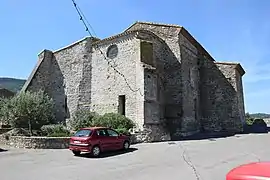 The Church of Saint-Julien | |
 Coat of arms | |
Location of Barbaira 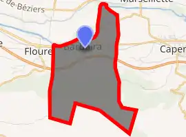
| |
 Barbaira  Barbaira | |
| Coordinates: 43°11′09″N 2°30′46″E | |
| Country | France |
| Region | Occitanie |
| Department | Aude |
| Arrondissement | Carcassonne |
| Canton | La Montagne d'Alaric |
| Intercommunality | Piémont d'Alaric |
| Government | |
| • Mayor (2014–2020) | Jacques Fabre |
| Area 1 | 9.40 km2 (3.63 sq mi) |
| Population (2017-01-01)[1] | 750 |
| • Density | 80/km2 (210/sq mi) |
| Time zone | UTC+01:00 (CET) |
| • Summer (DST) | UTC+02:00 (CEST) |
| INSEE/Postal code | 11027 /11800 |
| Elevation | 66–502 m (217–1,647 ft) (avg. 75 m or 246 ft) |
| 1 French Land Register data, which excludes lakes, ponds, glaciers > 1 km2 (0.386 sq mi or 247 acres) and river estuaries. | |
The inhabitants of the commune are known as Barbairanais or Barbairanaises.[2]
Geography
Barbaira is located in the Corbières Massif, at the foot of Mount Alaric in the urban area of Carcassonne some 15 km east of the city. Access to the commune is by the D6113 road from Floure in the west which passes through the north of the commune and the village before continuing east to Capendu. The A61 autoroute passes through the centre of the commune from west to east but there is no exit in the commune. The nearest exit is Exit ![]() 24 some 7 km to the west of the commune which links to the D6113. A railway passes through commune and the village from west to east but has no station in or near the commune. The commune is farmland in the north with the slopes of the mountain in the south forested.[3]
24 some 7 km to the west of the commune which links to the D6113. A railway passes through commune and the village from west to east but has no station in or near the commune. The commune is farmland in the north with the slopes of the mountain in the south forested.[3]
The Aude river forms the northern border of the commune as it flows east to join the Mediterranean Sea south-west of Valras-Plage. Several streams rise in the south of the commune and flow north to join the Aude including the Ruisseau de la Pelliere. The Ruisseau de Saint-Jean rises in the far south-east of the commune and flows north then east to join the Ruisseau de la Tuilerie.[3]
Neighbouring communes and villages
Places adjacent to Barbaira | |
|---|---|
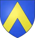
Heraldry
Arms of Barbaira |
The official status of the blazon remains to be determined.
Blazon: |
Administration
| From | To | Name |
|---|---|---|
| 1792 | 1796 | Pierre Agussol |
| 1796 | 1797 | Laurens Marty |
| 1797 | 1798 | Jean Besiat |
| 1798 | 1800 | Pierre Agussol |
| 1800 | 1806 | François Bel |
| 1806 | 1813 | Noël Bel |
| 1813 | 1816 | Pierre Agussol |
| 1816 | 1818 | Pierre Huillet |
| 1818 | 1819 | Jacques Huillet |
| 1819 | 1821 | Jean Baptiste Dalbès |
| 1821 | 1826 | Jacques Cabrié |
| 1826 | 1829 | Jacques Huillet |
| 1829 | 1830 | Louis Pascal Marty |
| 1830 | 1840 | Antoine Bel |
| 1840 | 1846 | Adrien Bel |
| 1846 | 1869 | Philippe Aybram |
| 1869 | 1870 | Pierre Robert |
| 1870 | 1871 | Alcide Jeantet |
| 1871 | 1876 | Pierre Bel |
| 1876 | 1882 | Alcide Jeantot |
| 1882 | 1884 | Maurice Prouzet |
| 1884 | 1888 | Félix Joucla |
| 1888 | 1892 | Maurice Prouzet |
| 1892 | 1900 | Casimir Rigaud |
| 1900 | 1919 | Auguste Robert |
| 1919 | 1936 | François Sarda |
- Mayors from 1936
| From | To | Name | Party | Position |
|---|---|---|---|---|
| 1936 | 1944 | Etienne Daydé | ||
| 1944 | 1953 | François Viguier | ||
| 1953 | 1965 | Jean Vibes | ||
| 1965 | 1995 | Emile Bacquier | ||
| 1995 | 2014 | Robert Amouroux | ||
| 2014 | 2020 | Jacques Fabre |
(Not all data is known)
Demography
In 2017 the commune had 750 inhabitants.
|
| ||||||||||||||||||||||||||||||||||||||||||||||||||||||||||||||||||||||||||||||||||||||||||||||||||||||||||||||||||
| Source: EHESS[5] and INSEE[6] | |||||||||||||||||||||||||||||||||||||||||||||||||||||||||||||||||||||||||||||||||||||||||||||||||||||||||||||||||||
Economy
Industry
There is a Compressor station for the TIGF natural gas network.[7]
Agriculture
The commune is part of the zone for the qualitative names:
- Vin de pays des coteaux de Miramont (Vin de Pays from the slopes of Miramont)
- Vignoble de la Montagne d'Alaric (Vineyards of Mount Alaric) which is part of the Corbières AOC
Culture and heritage
.jpg.webp)
Civil heritage
- The remains of the Chateau of Miramont (Middle Ages)
 are registered as an historical monument.[8]
Religious heritage
- The Church of Saint-Julien-Sainte-Basilisse (12th century) is registered as an historical monument.[9] The Church contains two items that are registered as historical objects:
- A Baptismal font (18th century)
 [10]
[10] - A Statue: Virgin and child (17th century)[11]
- A Baptismal font (18th century)
Notable people linked to the commune
- Chabert de Barbeira
References
- "Populations légales 2017". INSEE. Retrieved 6 January 2020.
- Inhabitants of Aude (in French)
- Google Maps
- List of Mayors of France (in French)
- Données Cassini, EHESS
- Population en historique depuis 1968, INSEE
- TIGF website (in French)
- Ministry of Culture, Mérimée PA00102552 Chateau of Miramont (in French)
- Ministry of Culture, Mérimée PA00102553 IA11000076 Church of Saint-Julien-Sainte-Basilisse(in French)

- Ministry of Culture, Palissy PM11000624 Baptismal font (in French)
- Ministry of Culture, Palissy PM11000623 Statue: Virgin and child (in French)
External links
- Barbaira on Lion1906
- Barbaira on Géoportail, National Geographic Institute (IGN) website (in French)
- Barbaira on the 1750 Cassini Map
| Wikimedia Commons has media related to Barbaira. |
| Authority control |
|---|
