Auriac, Aude
Auriac (French pronunciation: [oʁjak] (![]() listen)) is a commune in the Aude department in the Occitanie region of southern France.
listen)) is a commune in the Aude department in the Occitanie region of southern France.
Auriac | |
|---|---|
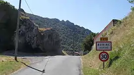 The road into Auriac | |
.svg.png.webp) Coat of arms | |
Location of Auriac 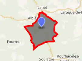
| |
 Auriac  Auriac | |
| Coordinates: 42°55′56″N 2°29′34″E | |
| Country | France |
| Region | Occitanie |
| Department | Aude |
| Arrondissement | Narbonne |
| Canton | Les Corbières |
| Intercommunality | CC Région Lézignanaise Corbières Minervois |
| Government | |
| • Mayor (2020–2026) | Bernard Sutra |
| Area 1 | 20.93 km2 (8.08 sq mi) |
| Population | 43 |
| • Density | 2.1/km2 (5.3/sq mi) |
| Time zone | UTC+01:00 (CET) |
| • Summer (DST) | UTC+02:00 (CEST) |
| INSEE/Postal code | 11020 /11330 |
| Elevation | 356–907 m (1,168–2,976 ft) (avg. 568 m or 1,864 ft) |
| 1 French Land Register data, which excludes lakes, ponds, glaciers > 1 km2 (0.386 sq mi or 247 acres) and river estuaries. | |
The inhabitants of the commune are known as Auriacois or Auriacoises.[2]
Geography
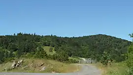
The commune is located in the Corbières Massif some 35 km south-east of Limoux and 15 km east of Arques. Access to the commune is by the D212 road which branches from the D613 west of Mouthoumet and goes south through the commune by a tortuous route then continues south to join the D10 north-east of Soulatgé. Apart from the village there are the hamlets of Savugnan in the south-west and La Grave north of the village. The whole of the commune is rugged and heavily forested.[3]
Many streams rise all over the commune and flow northwards to join the Orbieu which flows through the commune from south-west to north to eventually join the Aude near Raissac-d'Aude.[3]
Neighbouring communes and villages
Places adjacent to Auriac, Aude | |
|---|---|
Heraldry
Arms of Auriac |
The official status of the blazon remains to be determined.
Blazon: |
Administration
List of Successive Mayors[4]
| From | To | Name | Party | Position |
|---|---|---|---|---|
| 2001 | 2014 | Yvette Fabre | ||
| 2014 | 2020 | Jean Simon |
(Not all data is known)
Demography
In 2017 the commune had 43 inhabitants.
|
| ||||||||||||||||||||||||||||||||||||||||||||||||||||||||||||||||||||||||||||||||||||||||||||||||||||||||||||||||||
| Source: EHESS[5] and INSEE[6] | |||||||||||||||||||||||||||||||||||||||||||||||||||||||||||||||||||||||||||||||||||||||||||||||||||||||||||||||||||
Culture and heritage
Civil heritage
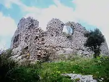
The commune has one building that is registered as an historical monument:
- The Ruins of a Chateau (11th century)
 [7]
[7]
See also
References
- "Populations légales 2017". INSEE. Retrieved 6 January 2020.
- Inhabitants of Aude (in French)
- Google Maps
- List of Mayors of France (in French)
- Des villages de Cassini aux communes d'aujourd'hui: Commune data sheet Auriac, EHESS. (in French)
- Population en historique depuis 1968, INSEE
- Ministry of Culture, Mérimée PA00102545 Ruins of a Chateau (in French)

- Ministry of Culture, Mérimée PA00102544 Chapel of Saint-André (in French)
- Ministry of Culture, Palissy PM11002132 Cope and Chasuble (in French)
External links
- Auriac on Géoportail, National Geographic Institute (IGN) website (in French)
- Auriac on the 1750 Cassini Map
| Wikimedia Commons has media related to Auriac (Aude). |
| Authority control |
|---|