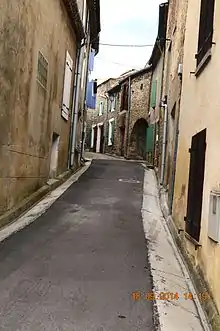
Arquettes-en-Val
Arquettes-en-Val is a commune in the Aude department in the Occitanie region of southern France.
Arquettes-en-Val | |
|---|---|
 The Town Hall | |
.svg.png.webp) Coat of arms | |
Location of Arquettes-en-Val 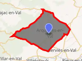
| |
 Arquettes-en-Val  Arquettes-en-Val | |
| Coordinates: 43°06′14″N 2°30′11″E | |
| Country | France |
| Region | Occitanie |
| Department | Aude |
| Arrondissement | Carcassonne |
| Canton | La Montagne d'Alaric |
| Intercommunality | Carcassonne Agglo |
| Government | |
| • Mayor (2014-2020) | André Pech |
| Area 1 | 9.31 km2 (3.59 sq mi) |
| Population (2017-01-01)[1] | 79 |
| • Density | 8.5/km2 (22/sq mi) |
| Time zone | UTC+01:00 (CET) |
| • Summer (DST) | UTC+02:00 (CEST) |
| INSEE/Postal code | 11016 /11220 |
| Elevation | 195–561 m (640–1,841 ft) (avg. 200 m or 660 ft) |
| 1 French Land Register data, which excludes lakes, ponds, glaciers > 1 km2 (0.386 sq mi or 247 acres) and river estuaries. | |
The inhabitants of the commune are known as Arquettois or Arquettoises[2]
The commune is one of the rare ones in France that are free of debt.[3]
Geography
Arquettes-sur-Val is located some 16 km south-east of Carcassonne and 4 km south-west of Montlaur. Access to the commune is by the D42 road from Palaja in the north-west passing through the commune and the village and continuing south to Serviès-en-Val. The D114 goes north-east from Serviès-en-Val to form part of the eastern border of the commune before joining the D3. The D714 road connects the D3 east of the commune to the village. The D310 goes south-west from the village to Villetritouls. The commune is rugged and forested in the north-west giving way to farmland in the south-east.[4]
The Ruisseau des Lys rises in the north-east of the commune and flows south-east gathering many tributaries. The Ruisseau de Jonquiere rises near the village and flows south-east. The Ruisseau de Lanes rises in the north-west of the commune and also flows south-west gathering many tributaries. All of the streams join the Sou south-west of the commune.[4]
Neighbouring communes and villages
Places adjacent to Arquettes-en-Val | ||||||||||
|---|---|---|---|---|---|---|---|---|---|---|
| ||||||||||
History
Heraldry
Arms of Arquettes-en-Val |
Blazon: Argent, 2 bends of Sable. |
Administration
List of Successive Mayors[5]
| From | To | Name | Party | Position |
|---|---|---|---|---|
| 1983 | 2001 | Georges Bouges | ||
| 2001 | 2008 | Bruno Séguy | ||
| 2008 | 2010 | Lionel Carabosa | ||
| 2010 | 2014 | Bruno Séguy | ||
| 2014 | 2020 | André Pech |
(Not all data is known)
Demography
In 2017 the commune had 79 inhabitants.
|
| ||||||||||||||||||||||||||||||||||||||||||||||||||||||||||||||||||||||||||||||||||||||||||||||||||||||||||||||||||
| Source: EHESS[6] and INSEE[7] | |||||||||||||||||||||||||||||||||||||||||||||||||||||||||||||||||||||||||||||||||||||||||||||||||||||||||||||||||||
Religious heritage

The Church contains a Chasuble, Stole, Maniple, and Bourse de Corporal (17th century)![]() which are registered as an historical object.[8]
which are registered as an historical object.[8]
Notable people linked to the commune
- Oliver de Termes (1200-1274), Lord of Termes and Arquettes-en-Val.
- Émile Pouytès, born at Rieux-Minervois on 1 June 1924, died at Montredon-des-Corbières on 4 March 1976. a winemaker in Arquettes-en-Val who attended a viticultural demonstration and was killed. There is a commemoration on the 1st Sunday of March at the Montredon-des-Corbières bridge.
References
- "Populations légales 2017". INSEE. Retrieved 6 January 2020.
- Inhabitants of Aude (in French)
- "La Depeche" Article 24 January 2012 (in French)
- Google Maps
- List of Mayors of France (in French)
- Données Cassini, EHESS
- Population en historique depuis 1968, INSEE
- Ministry of Culture, Palissy PM11001713 Chasuble, Stole, Maniple, and Bourse de Corporal (in French)
External links
- Arquettes-en-Val on the National Geographic Institute website (in French)
- Arquettes-en-Val on Lion1906
- Arquettes-en-Val on Géoportail, National Geographic Institute (IGN) website (in French)
- Arquetes on the 1750 Cassini Map
| Wikimedia Commons has media related to Arquettes-en-Val. |
| Authority control |
|---|