Caux-et-Sauzens
Caux-et-Sauzens is a commune in the Aude department in southern France.
Caux-et-Sauzens | |
|---|---|
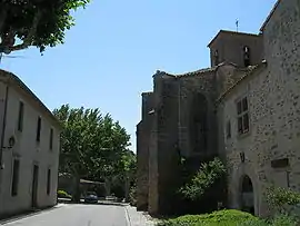 The town hall and church in Caux-et-Sauzens | |
.svg.png.webp) Coat of arms | |
Location of Caux-et-Sauzens 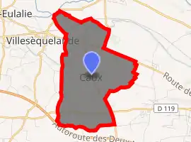
| |
 Caux-et-Sauzens  Caux-et-Sauzens | |
| Coordinates: 43°13′36″N 2°15′23″E | |
| Country | France |
| Region | Occitanie |
| Department | Aude |
| Arrondissement | Carcassonne |
| Canton | La Malepère à la Montagne Noire |
| Intercommunality | Carcassonnais |
| Government | |
| • Mayor (2008–2014) | Angel Esteban |
| Area 1 | 9 km2 (3 sq mi) |
| Population (2017-01-01)[1] | 979 |
| • Density | 110/km2 (280/sq mi) |
| Time zone | UTC+01:00 (CET) |
| • Summer (DST) | UTC+02:00 (CEST) |
| INSEE/Postal code | 11084 /11170 |
| Elevation | 103–177 m (338–581 ft) (avg. 150 m or 490 ft) |
| 1 French Land Register data, which excludes lakes, ponds, glaciers > 1 km2 (0.386 sq mi or 247 acres) and river estuaries. | |
Located 8 kilometres west of Carcassonne between the Montagne Noire and Malepère, at the crossroads of the old Roman roads to Toulouse and from Foix towards Ariège and Spain. The Canal du Midi runs between the Village of Caux and the Hamlet of Sauzens. Its inhabitants are known as Cauxois.
History
The hamlet of Sauzens and the village Caux joined to form Caux et Sauzens during the French revolution in 1791.
Population
| Year | Pop. | ±% |
|---|---|---|
| 1793 | 508 | — |
| 1800 | 504 | −0.8% |
| 1806 | 531 | +5.4% |
| 1821 | 507 | −4.5% |
| 1831 | 465 | −8.3% |
| 1836 | 487 | +4.7% |
| 1841 | 488 | +0.2% |
| 1846 | 493 | +1.0% |
| 1851 | 508 | +3.0% |
| 1856 | 496 | −2.4% |
| 1861 | 446 | −10.1% |
| 1866 | 422 | −5.4% |
| 1872 | 432 | +2.4% |
| 1876 | 422 | −2.3% |
| 1881 | 520 | +23.2% |
| 1886 | 540 | +3.8% |
| 1891 | 527 | −2.4% |
| 1896 | 553 | +4.9% |
| 1901 | 551 | −0.4% |
| 1906 | 556 | +0.9% |
| 1911 | 522 | −6.1% |
| 1921 | 503 | −3.6% |
| 1926 | 524 | +4.2% |
| 1931 | 556 | +6.1% |
| 1936 | 505 | −9.2% |
| 1946 | 507 | +0.4% |
| 1954 | 510 | +0.6% |
| 1962 | 450 | −11.8% |
| 1968 | 429 | −4.7% |
| 1975 | 516 | +20.3% |
| 1982 | 594 | +15.1% |
| 1990 | 705 | +18.7% |
| 1999 | 739 | +4.8% |
| 2009 | 776 | +5.0% |
See also
References
- "Populations légales 2017". INSEE. Retrieved 6 January 2020.
- "Institut national de la statistique et des études économiques Résultats du recensement de la population - 2009 - Caux-et-Sauzens". INSEE. Retrieved 2013-04-18.
External links
| Wikimedia Commons has media related to Caux-et-Sauzens. |
- Official website (in French)
| Authority control |
|---|
This article is issued from Wikipedia. The text is licensed under Creative Commons - Attribution - Sharealike. Additional terms may apply for the media files.