Arrondissement of Nontron
The arrondissement of Nontron is an arrondissement of France in the Dordogne department in the Nouvelle-Aquitaine region. It has 94 communes.[1] Its population is 54,758 (2016), and its area is 2,097.7 km2 (809.9 sq mi).[2]
Nontron | |
|---|---|
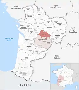 Location within the region Nouvelle-Aquitaine | |
| Country | France |
| Region | Nouvelle-Aquitaine |
| Department | Dordogne |
| No. of communes | 94 |
| Subprefecture | Nontron |
| Area | |
| • Total | 2,097.7 km2 (809.9 sq mi) |
| Population (2016) | |
| • Total | 54,758 |
| • Density | 26/km2 (70/sq mi) |
| INSEE code | 242 |
Composition
The communes of the arrondissement of Nontron, and their INSEE codes, are:[1]
- Abjat-sur-Bandiat (24001)
- Angoisse (24008)
- Anlhiac (24009)
- Augignac (24016)
- Biras (24042)
- Bourdeilles (24055)
- Le Bourdeix (24056)
- Brantôme en Périgord (24064)
- Brouchaud (24066)
- Bussac (24069)
- Busserolles (24070)
- Bussière-Badil (24071)
- Chalais (24095)
- Champagnac-de-Belair (24096)
- Champniers-et-Reilhac (24100)
- Champs-Romain (24101)
- La Chapelle-Faucher (24107)
- La Chapelle-Montmoreau (24111)
- Cherveix-Cubas (24120)
- Clermont-d'Excideuil (24124)
- Condat-sur-Trincou (24129)
- Connezac (24131)
- La Coquille (24133)
- Corgnac-sur-l'Isle (24134)
- Coulaures (24137)
- Cubjac-Auvézère-Val d'Ans (24147)
- Dussac (24158)
- Étouars (24163)
- Excideuil (24164)
- Eyzerac (24171)
- Firbeix (24180)
- Génis (24196)
- Hautefaye (24209)
- Javerlhac-et-la-Chapelle-Saint-Robert (24214)
- Jumilhac-le-Grand (24218)
- Lanouaille (24227)
- Lempzours (24238)
- Lussas-et-Nontronneau (24248)
- Mareuil en Périgord (24253)
- Mayac (24262)
- Mialet (24269)
- Milhac-de-Nontron (24271)
- Nantheuil (24304)
- Nanthiat (24305)
- Négrondes (24308)
- Nontron (24311)
- Payzac (24320)
- Piégut-Pluviers (24328)
- Preyssac-d'Excideuil (24339)
- Quinsac (24346)
- La Rochebeaucourt-et-Argentine (24353)
- Rudeau-Ladosse (24221)
- Saint-Barthélemy-de-Bussière (24381)
- Saint-Cyr-les-Champagnes (24397)
- Sainte-Croix-de-Mareuil (24394)
- Saint-Estèphe (24398)
- Saint-Félix-de-Bourdeilles (24403)
- Saint-Front-d'Alemps (24408)
- Saint-Front-la-Rivière (24410)
- Saint-Front-sur-Nizonne (24411)
- Saint-Germain-des-Prés (24417)
- Saint-Jean-de-Côle (24425)
- Saint-Jory-de-Chalais (24428)
- Saint-Jory-las-Bloux (24429)
- Saint-Martial-d'Albarède (24448)
- Saint-Martial-de-Valette (24451)
- Saint-Martin-de-Fressengeas (24453)
- Saint-Martin-le-Pin (24458)
- Saint-Médard-d'Excideuil (24463)
- Saint-Mesmin (24464)
- Saint-Pancrace (24474)
- Saint-Pantaly-d'Excideuil (24476)
- Saint-Pardoux-la-Rivière (24479)
- Saint-Paul-la-Roche (24481)
- Saint-Pierre-de-Côle (24485)
- Saint-Pierre-de-Frugie (24486)
- Saint-Priest-les-Fougères (24489)
- Saint-Raphaël (24493)
- Saint-Romain-et-Saint-Clément (24496)
- Saint-Saud-Lacoussière (24498)
- Saint-Sulpice-d'Excideuil (24505)
- Saint-Vincent-sur-l'Isle (24513)
- Salagnac (24515)
- Sarlande (24519)
- Sarrazac (24522)
- Savignac-de-Nontron (24525)
- Savignac-Lédrier (24526)
- Sceau-Saint-Angel (24528)
- Soudat (24541)
- Teyjat (24548)
- Thiviers (24551)
- Varaignes (24565)
- Vaunac (24567)
- Villars (24582)
History
The arrondissement of Nontron was created in 1800.[3] At the January 2017 reorganisation of the arrondissements of Dordogne, it gained 28 communes from the arrondissement of Périgueux.[4]
As a result of the reorganisation of the cantons of France which came into effect in 2015, the borders of the cantons are no longer related to the borders of the arrondissements. The cantons of the arrondissement of Nontron were, as of January 2015:[5]
- Bussière-Badil
- Champagnac-de-Belair
- Jumilhac-le-Grand
- Lanouaille
- Mareuil
- Nontron
- Saint-Pardoux-la-Rivière
- Thiviers
References
- "Arrondissement de Nontron (242)". INSEE. Retrieved 2019-09-29.
- "Comparateur de territoire, géographie au 01/01/2019". INSEE. Retrieved 2019-09-29.
- Historique de la Dordogne
- "Arrêté préfectoral, 30 December 2016" (PDF). pp. 132–140. Retrieved 2019-10-09.
- "Populations légales 2012" (PDF). INSEE. December 2014. Retrieved 2019-10-09.
This article is issued from Wikipedia. The text is licensed under Creative Commons - Attribution - Sharealike. Additional terms may apply for the media files.