Villars, Dordogne
Villars is a commune in the Dordogne department in Nouvelle-Aquitaine in southwestern France. Nearby towns include Brantôme and Nontron.
Villars | |
|---|---|
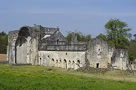 The ruins of Boschaud abbey in Villars | |
Location of Villars 
| |
 Villars  Villars | |
| Coordinates: 45°25′17″N 0°45′21″E | |
| Country | France |
| Region | Nouvelle-Aquitaine |
| Department | Dordogne |
| Arrondissement | Nontron |
| Canton | Brantôme en Périgord |
| Government | |
| • Mayor (2008–2014) | Jean-Pierre Grolhier |
| Area 1 | 27.67 km2 (10.68 sq mi) |
| Population (2017-01-01)[1] | 463 |
| • Density | 17/km2 (43/sq mi) |
| Time zone | UTC+01:00 (CET) |
| • Summer (DST) | UTC+02:00 (CEST) |
| INSEE/Postal code | 24582 /24530 |
| Elevation | 125–240 m (410–787 ft) (avg. 225 m or 738 ft) |
| 1 French Land Register data, which excludes lakes, ponds, glaciers > 1 km2 (0.386 sq mi or 247 acres) and river estuaries. | |
Villars' attractions include the Château de Puyguilhem,[2] Grotte de Villars and the Abbaye de Boschaud.
Population
|
|
See also
References
- "Populations légales 2017". INSEE. Retrieved 6 January 2020.
- "Monuments historiques: Castle of Puyguilhem (reference PA00083065)". Ministère de la Culture et de la Communication. Retrieved 28 April 2017.
| Wikimedia Commons has media related to Villars, Dordogne. |
| Authority control |
|---|
This article is issued from Wikipedia. The text is licensed under Creative Commons - Attribution - Sharealike. Additional terms may apply for the media files.