Aurora, Zamboanga del Sur
Aurora, officially the Municipality of Aurora (Cebuano: Lungsod sa Aurora; Subanen: Benwa Aurora; Chavacano: Municipalidad de Aurora; Tagalog: Bayan ng Aurora), is a 2nd class municipality in the province of Zamboanga del Sur, Philippines. According to the 2015 census, it has a population of 50,755 people. [3]
Aurora | |
|---|---|
| Municipality of Aurora | |
 Seal | |
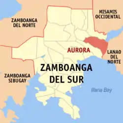 Map of Zamboanga del Sur with Aurora highlighted | |
OpenStreetMap 
| |
.svg.png.webp) Aurora Location within the Philippines | |
| Coordinates: 7°56′54″N 123°34′55″E | |
| Country | |
| Region | Zamboanga Peninsula (Region IX) |
| Province | Zamboanga del Sur |
| District | 1st District |
| Founded | August 22, 1942 |
| Barangays | 44 (see Barangays) |
| Government | |
| • Type | Sangguniang Bayan |
| • Mayor | Boen Dorotheo R. Cabahug |
| • Vice Mayor | Silvano C. Zanoria |
| • Representative | Divina Grace C. Yu |
| • Electorate | 34,578 voters (2019) |
| Area | |
| • Total | 180.95 km2 (69.87 sq mi) |
| Elevation | 157 m (515 ft) |
| Population | |
| • Total | 50,755 |
| • Density | 280/km2 (730/sq mi) |
| • Households | 10,980 |
| Economy | |
| • Income class | 2nd municipal income class |
| • Poverty incidence | 34.64% (2015)[4] |
| • Revenue | ₱147,588,926.33 (2016) |
| Time zone | UTC+8 (PST) |
| ZIP code | 7020 |
| PSGC | |
| IDD : area code | +63 (0)62 |
| Climate type | tropical climate |
| Native languages | Subanon Cebuano Chavacano Tagalog |
| Website | aurorazds |
The town was named after President Manuel Quezon's wife, Aurora Quezon.
In 1948, a portion of Aurora was separated to form the town of Molave.[5]
Geography
It is the easternmost municipality in Zamboanga del Sur, bounded by the Province of Lanao del Norte on its eastern side.
Barangays
Aurora is politically subdivided into 44 barangays.
- Acad
- Alang-alang
- Alegria
- Anonang
- Bagong Mandaue
- Bagong Maslog
- Bagong Oslob
- Bagong Pitogo
- Baki
- Balas
- Balide
- Balintawak
- Bayabas
- Bemposa
- Cabilinan
- Campo Uno
- Ceboneg
- Commonwealth
- Gubaan
- Inasagan
- Inroad
- Kahayagan East (Katipunan)
- Kahayagan West
- Kauswagan
- La Paz (Tinibtiban)
- La Victoria
- Lantungan
- Libertad
- Lintugop
- Lubid
- Maguikay
- Mahayahay
- Monte Alegre
- Montela
- Napo
- Panaghiusa
- Poblacion
- Resthouse
- Romarate
- San Jose
- San Juan
- Sapa Loboc
- Tagulalo
- Waterfall
Climate
| Climate data for Aurora, Zamboanga del Sur | |||||||||||||
|---|---|---|---|---|---|---|---|---|---|---|---|---|---|
| Month | Jan | Feb | Mar | Apr | May | Jun | Jul | Aug | Sep | Oct | Nov | Dec | Year |
| Average high °C (°F) | 28 (82) |
28 (82) |
29 (84) |
30 (86) |
29 (84) |
28 (82) |
28 (82) |
28 (82) |
28 (82) |
28 (82) |
28 (82) |
28 (82) |
28 (83) |
| Average low °C (°F) | 21 (70) |
21 (70) |
21 (70) |
22 (72) |
23 (73) |
23 (73) |
22 (72) |
22 (72) |
22 (72) |
22 (72) |
22 (72) |
21 (70) |
22 (72) |
| Average precipitation mm (inches) | 69 (2.7) |
58 (2.3) |
67 (2.6) |
60 (2.4) |
109 (4.3) |
114 (4.5) |
83 (3.3) |
78 (3.1) |
76 (3.0) |
92 (3.6) |
86 (3.4) |
63 (2.5) |
955 (37.7) |
| Average rainy days | 12.8 | 11.6 | 14.8 | 17.4 | 24.8 | 23.5 | 20.7 | 18.5 | 17.4 | 22.5 | 21.6 | 15.6 | 221.2 |
| Source: Meteoblue [6] | |||||||||||||
Demographics
| Year | Pop. | ±% p.a. |
|---|---|---|
| 1948 | 35,090 | — |
| 1960 | 25,558 | −2.61% |
| 1970 | 25,975 | +0.16% |
| 1975 | 31,092 | +3.67% |
| 1980 | 37,248 | +3.68% |
| 1990 | 38,097 | +0.23% |
| 1995 | 40,157 | +0.99% |
| 2000 | 42,820 | +1.39% |
| 2007 | 47,177 | +1.35% |
| 2010 | 48,434 | +0.96% |
| 2015 | 50,755 | +0.90% |
| Source: Philippine Statistics Authority [3] [7] [8][9] | ||
References
- Municipality of Aurora | (DILG)
- "Province: Zamboanga del Sur". PSGC Interactive. Quezon City, Philippines: Philippine Statistics Authority. Retrieved 12 November 2016.
- Census of Population (2015). "Region IX (Zamboanga Peninsula)". Total Population by Province, City, Municipality and Barangay. PSA. Retrieved 20 June 2016.
- "PSA releases the 2015 Municipal and City Level Poverty Estimates". Quezon City, Philippines. Retrieved 12 October 2019.
- "An act creating the municipality of Molave in the province of Zamboanga and making said municipality the capital of the province". LawPH.com. Retrieved 2011-04-08.
- "Aurora: Average Temperatures and Rainfall". Meteoblue. Retrieved 1 May 2020.
- Census of Population and Housing (2010). "Region IX (Zamboanga Peninsula)". Total Population by Province, City, Municipality and Barangay. NSO. Retrieved 29 June 2016.
- Censuses of Population (1903–2007). "Region IX (Zamboanga Peninsula)". Table 1. Population Enumerated in Various Censuses by Province/Highly Urbanized City: 1903 to 2007. NSO.
- "Province of Zamboanga del Sur". Municipality Population Data. Local Water Utilities Administration Research Division. Retrieved 17 December 2016.
External links
Places adjacent to Aurora, Zamboanga del Sur | |
|---|---|
Pagadian (capital) | |
| Municipalities | |
| Component city | |
| Highly urbanized city |
|
This article is issued from Wikipedia. The text is licensed under Creative Commons - Attribution - Sharealike. Additional terms may apply for the media files.