Bình Thủy District
Bình Thủy is a district of Cần Thơ in the Mekong Delta region of Vietnam. Its Khmer name is Kâmpoul Meas (កំពូលមាស).[1] As of 2003 the district had a population of 87,665.[2] The district covers an area of 69 km².[2]
Bình Thủy District
Quận Bình Thủy | |
|---|---|
 | |
| Country | |
| Province | Cần Thơ |
| Area | |
| • Total | 27 sq mi (69 km2) |
| Population (2018) | |
| • Total | 172,317 |
| Time zone | UTC+07:00 (Indochina Time) |
Administrative divisions
The district is divided into 8 wards (phường):
- Trà Nóc: 712 ha, 10,513 people (2007)
- Trà An: 565.67 ha, 5,339 people (2007)
- An Thới: 384.83 ha, 14,445 people (2007)
- Bùi Hữu Nghĩa: 637.12 ha, 11,185 people (2007)
- Thới An Đông: 1,167.56 ha, 9,438 people (2004)
- Bình Thuỷ
- Long Tuyền: 1,413.55 ha, 13,250 people (2004)
- Long Hoà: 1,395.08 ha, 13,471 people (2004).
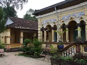
Notable landmarks
- Đình Bình Thủy
- Long Quang Pagoda
References
- សទ្ទានុក្រមខេមរយានកម្មបារាំង-ខ្មែរ, ភ្នំពេញ ក្រសួងអប់រំជាតិ វិទ្យាស្ថានខេមរយានកម្ម គ.ស. ១៩៧៣, ទំព័រ ៣៨៩ ។
- "Districts of Vietnam". Statoids. Retrieved March 13, 2009.
This article is issued from Wikipedia. The text is licensed under Creative Commons - Attribution - Sharealike. Additional terms may apply for the media files.