Châu Thành District, An Giang Province
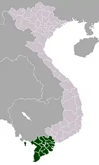
Châu Thành is a district (huyện) of An Giang Province in the Mekong Delta region of Vietnam.
Châu Thành District
Huyện Châu Thành | |
|---|---|
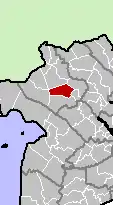 Location in An Giang Province | |
| Country | |
| Province | An Giang |
| Capital | An Châu |
| Area | |
| • Total | 134.1 sq mi (347.2 km2) |
| Population (2003) | |
| • Total | 171,480 |
| Time zone | UTC+07:00 (Indochina Time) |
As of 2003 the district had a population of 171,480.[1] The district covers an area of 347 km². The district capital lies at An Châu.[1]
It was created when the district Châu Thành X was split into Châu Thành and Thoại Sơn District, under decree 300/CP on August 23, 1979. Under South Vietnam, it was part of Long Xuyên Province.
The district comprises the thị trấn An Châu (huyện lỵ) and 12 communes, which include a total of 63 hamlets. It borders four other districts, these being Tịnh Biên District, Châu Phú District, Chợ Mới, Thoại Sơn District and the nearby city of Long Xuyên.
The terrain is flat, and is bisected by the Hậu River.
The ethnic groups in the area in order of size, are ethnic Vietnamese, Khmer Krom, Cham, and Hoa. Hòa Hảo is the most common religion in the area.
References
- "Districts of Vietnam". Statoids. Retrieved March 13, 2009.