Bảo Thắng District
Bảo Thắng is a rural district (huyện) of Lào Cai Province in the Northeast region of Vietnam.
Bảo Thắng District
Huyện Bảo Thắng | |
|---|---|
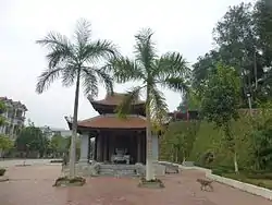 A monument in Phố Lu | |
| Country | |
| Region | Northeast |
| Province | Lào Cai |
| Capital | Phố Lu |
| Area | |
| • Total | 260 sq mi (674 km2) |
| Population (2003) | |
| • Total | 107,174 |
| Time zone | UTC+07:00 (Indochina Standard Time) |
As of 2003, the district had a population of 107,174.[1] The district covers an area of 674 km². The district capital lies at Phố Lu.[1]
History
The administrative unit of Bảo Thắng was first established in 1059 by the Lý dynasty.[2]
Administrative divisions
Phố Lu (district capital), Phong Hải, Tằng Loỏng, Phú Nhuận, Phố Lu, Sơn Hà, Trì Quang, Xuân Quang, Phong Niên, Xuân Giao, Gia Phú, Sơn Hải, Thái Niên, Bản Cầm and Bản Phiệt.
References
- "Districts of Vietnam". Statoids. Archived from the original on 31 March 2009. Retrieved March 23, 2009.
- James Anderson The Rebel Den of Nùng Trí Cao: Loyalty and Identity Along ... 2007 - Page 129 "In 1059, the Ly court made an additional effort to take direct control of its frontier and the local manpower. The court divided the northern frontier in the Left and Right rivers region into the new administrative units Ngu Long, Vu Thang, Long Duc, Than Dien, Bong Thanh, Bảo Thắng (Bảo Thắng county, in modern-day Lào Cai province), Hung Lugc, and Van Tiep.35 To each of these units the court assigned ..."
Districts of Northwest Vietnam | ||
|---|---|---|
| Điện Biên Province | 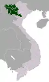 | |
| Hòa Bình Province | ||
| Lai Châu Province | ||
| Lào Cai Province | ||
| Sơn La Province | ||
| Yên Bái Province | ||
※ denotes provincial seat. | ||
This article is issued from Wikipedia. The text is licensed under Creative Commons - Attribution - Sharealike. Additional terms may apply for the media files.