Lào Cai
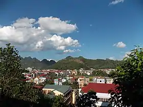
Lào Cai ([làːw kāːj] (![]() listen)) is a city in the Northwest region of Vietnam. It is the capital of Lào Cai Province. The city borders the city of Hekou Yao Autonomous County, in Yunnan province of southwest China. It lies at the junction of the Red River (Sông Hồng) and the Nanxi River (Yunnan) approximately 160 miles (260 km) northwest of Hanoi.[1]
listen)) is a city in the Northwest region of Vietnam. It is the capital of Lào Cai Province. The city borders the city of Hekou Yao Autonomous County, in Yunnan province of southwest China. It lies at the junction of the Red River (Sông Hồng) and the Nanxi River (Yunnan) approximately 160 miles (260 km) northwest of Hanoi.[1]
Lào Cai
Thành phố Lào Cai | |
|---|---|
| Lào Cai City | |
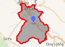
 Bát Xát district in Lào Cai | |
 Seal | |
| |
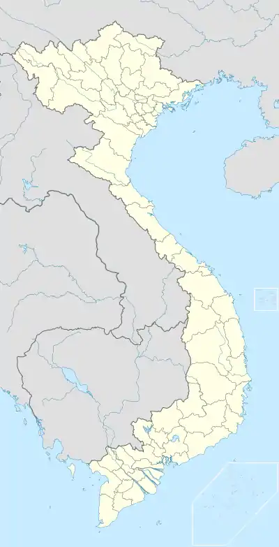 Lào Cai Location in Vietnam | |
| Coordinates: 22°28′50″N 103°58′30″E | |
| Country | Vietnam |
| Province | Lào Cai Province |
| Established city | 30 November 2004 |
| Area | |
| • Total | 229.67 km2 (88.68 sq mi) |
| Population (2018) | |
| • Total | 173,840 |
| Climate | Cwa |
It is a market town for timber, and the Lào Cai Railway Station is located on the Hải Phòng railway to Yunnan Province in China.
History
The town was invaded by China in 1979 and the border was closed until 1993.[2][3] The town has a carbide factory. As of 2003 the district had a population of 86,855.[4] The district covers an area of 223 km².[5]
Ethnic minorities in Lào Cai used to speak Southwestern Mandarin and Vietnamese to each other when their languages were not mutually intelligible.[6]
Climate
Lào Cai has a dry-winter humid subtropical climate (Köppen climate classification: Cwa), similar to most of Northern Vietnam.
| Climate data for Lào Cai | |||||||||||||
|---|---|---|---|---|---|---|---|---|---|---|---|---|---|
| Month | Jan | Feb | Mar | Apr | May | Jun | Jul | Aug | Sep | Oct | Nov | Dec | Year |
| Record high °C (°F) | 31.4 (88.5) |
34.6 (94.3) |
38.0 (100.4) |
38.1 (100.6) |
41.0 (105.8) |
40.1 (104.2) |
39.7 (103.5) |
40.0 (104.0) |
36.8 (98.2) |
37.2 (99.0) |
33.2 (91.8) |
31.5 (88.7) |
41.0 (105.8) |
| Average high °C (°F) | 20.1 (68.2) |
21.3 (70.3) |
25.3 (77.5) |
28.8 (83.8) |
32.1 (89.8) |
32.7 (90.9) |
32.7 (90.9) |
32.4 (90.3) |
31.3 (88.3) |
28.7 (83.7) |
25.1 (77.2) |
21.9 (71.4) |
27.7 (81.9) |
| Daily mean °C (°F) | 15.7 (60.3) |
17.0 (62.6) |
20.7 (69.3) |
24.2 (75.6) |
27.0 (80.6) |
27.9 (82.2) |
27.9 (82.2) |
27.5 (81.5) |
26.3 (79.3) |
24.0 (75.2) |
20.2 (68.4) |
17.0 (62.6) |
23.0 (73.4) |
| Average low °C (°F) | 13.3 (55.9) |
14.5 (58.1) |
17.9 (64.2) |
21.1 (70.0) |
23.6 (74.5) |
24.7 (76.5) |
24.9 (76.8) |
24.4 (75.9) |
23.3 (73.9) |
21.2 (70.2) |
17.5 (63.5) |
14.3 (57.7) |
20.0 (68.0) |
| Record low °C (°F) | 1.4 (34.5) |
5.6 (42.1) |
6.8 (44.2) |
10.0 (50.0) |
14.8 (58.6) |
18.7 (65.7) |
20.0 (68.0) |
17.3 (63.1) |
15.8 (60.4) |
8.8 (47.8) |
5.8 (42.4) |
2.8 (37.0) |
1.4 (34.5) |
| Average precipitation mm (inches) | 22 (0.9) |
33 (1.3) |
58 (2.3) |
129 (5.1) |
171 (6.7) |
239 (9.4) |
302 (11.9) |
355 (14.0) |
222 (8.7) |
153 (6.0) |
54 (2.1) |
27 (1.1) |
1,764 (69.4) |
| Average precipitation days | 7.8 | 8.8 | 11.5 | 15.8 | 16.8 | 18.7 | 20.9 | 21.1 | 15.8 | 14.8 | 10.2 | 7.7 | 169.8 |
| Average relative humidity (%) | 84.8 | 84.0 | 82.5 | 83.1 | 81.4 | 84.4 | 85.8 | 86.0 | 85.5 | 85.8 | 86.3 | 85.8 | 84.6 |
| Mean monthly sunshine hours | 80 | 70 | 102 | 142 | 180 | 145 | 158 | 160 | 158 | 133 | 109 | 104 | 1,539 |
| Source: Vietnam Institute for Building Science and Technology[7] | |||||||||||||
References
- Lào Cai profile in Britannica Online Encyclopedia
- Lào Cai info. at AccessVietnam Travel Archived 2007-12-16 at the Wayback Machine
- Forbes, Andrew, and Henley, David: Vietnam Past and Present: The North (History and culture of Hanoi and Tonkin). Chiang Mai. Cognoscenti Books, 2012. ASIN: B006DCCM9Q.
- "Districts of Vietnam". Statoids. Retrieved 23 March 2009.
- "Lao Cai Administrative Map". Laocai.gov.vn. Retrieved 21 June 2015.
- Masako Ito (2013). Politics of Ethnic Classification in Vietnam. Kyoto University Press. pp. 137–. ISBN 978-1-920901-72-1.
- "Vietnam Building Code Natural Physical & Climatic Data for Construction" (PDF). Vietnam Institute for Building Science and Technology. Archived from the original (PDF) on 22 July 2018. Retrieved 3 August 2018.
External links
Districts of Northwest Vietnam | ||
|---|---|---|
| Điện Biên Province |  | |
| Hòa Bình Province | ||
| Lai Châu Province | ||
| Lào Cai Province | ||
| Sơn La Province | ||
| Yên Bái Province | ||
※ denotes provincial seat. | ||
| Authority control |
|---|