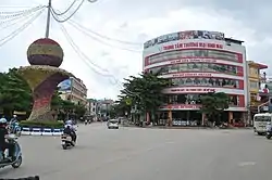
Sơn La
Sơn La (![]() listen) is a city in the north-west region of Vietnam. It is the capital of Sơn La Province.
listen) is a city in the north-west region of Vietnam. It is the capital of Sơn La Province.
Sơn La
Thành phố Sơn La | |
|---|---|
| Sơn La City | |
 | |

| |
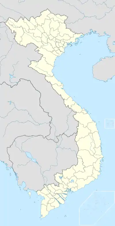 Sơn La Location of Sơn La in Vietnam | |
| Coordinates: 21°19′37″N 103°54′51″E | |
| Country | |
| Province | Sơn La |
| Area | |
| • Total | 323.51 km2 (124.91 sq mi) |
| Population | |
| • Total | 103,000 |
| • Density | 318/km2 (820/sq mi) |
History
In the era of the Sip Song Chau Tai, Sơn La was a fort of the Black Tai.[1][2][3]
Climate
Like most of Northern Vietnam, Sơn La has a dry-winter humid subtropical climate (Köppen climate classification: Cwa), affected by the East Asian monsoons.
| Climate data for Sơn La | |||||||||||||
|---|---|---|---|---|---|---|---|---|---|---|---|---|---|
| Month | Jan | Feb | Mar | Apr | May | Jun | Jul | Aug | Sep | Oct | Nov | Dec | Year |
| Record high °C (°F) | 30.6 (87.1) |
34.6 (94.3) |
36.3 (97.3) |
37.3 (99.1) |
38.0 (100.4) |
35.0 (95.0) |
35.3 (95.5) |
35.0 (95.0) |
33.3 (91.9) |
33.9 (93.0) |
31.3 (88.3) |
30.7 (87.3) |
38.0 (100.4) |
| Average high °C (°F) | 21.1 (70.0) |
23.1 (73.6) |
27.0 (80.6) |
29.7 (85.5) |
30.5 (86.9) |
29.9 (85.8) |
29.6 (85.3) |
29.5 (85.1) |
29.0 (84.2) |
27.0 (80.6) |
24.1 (75.4) |
21.6 (70.9) |
26.8 (80.2) |
| Daily mean °C (°F) | 14.9 (58.8) |
16.6 (61.9) |
20.2 (68.4) |
23.2 (73.8) |
24.8 (76.6) |
25.1 (77.2) |
25.1 (77.2) |
24.7 (76.5) |
23.7 (74.7) |
21.5 (70.7) |
18.2 (64.8) |
15.3 (59.5) |
21.1 (70.0) |
| Average low °C (°F) | 10.8 (51.4) |
12.3 (54.1) |
15.4 (59.7) |
18.5 (65.3) |
20.7 (69.3) |
22.0 (71.6) |
22.1 (71.8) |
21.7 (71.1) |
20.2 (68.4) |
17.7 (63.9) |
14.2 (57.6) |
10.9 (51.6) |
17.2 (63.0) |
| Record low °C (°F) | −0.8 (30.6) |
3.9 (39.0) |
4.8 (40.6) |
8.4 (47.1) |
13.7 (56.7) |
15.2 (59.4) |
17.2 (63.0) |
15.4 (59.7) |
13.4 (56.1) |
7.0 (44.6) |
3.6 (38.5) |
−0.8 (30.6) |
−0.8 (30.6) |
| Average precipitation mm (inches) | 18 (0.7) |
26 (1.0) |
48 (1.9) |
115 (4.5) |
187 (7.4) |
255 (10.0) |
265 (10.4) |
268 (10.6) |
136 (5.4) |
65 (2.6) |
35 (1.4) |
16 (0.6) |
1,434 (56.5) |
| Average precipitation days | 4.8 | 4.9 | 6.1 | 12.6 | 17.1 | 19.5 | 21.5 | 20.0 | 13.6 | 8.6 | 4.6 | 3.5 | 136.8 |
| Average relative humidity (%) | 78.6 | 75.4 | 72.2 | 74.3 | 77.8 | 83.3 | 85.1 | 85.9 | 84.2 | 82.2 | 80.6 | 78.8 | 79.9 |
| Mean monthly sunshine hours | 146 | 140 | 173 | 190 | 203 | 147 | 149 | 161 | 179 | 182 | 158 | 171 | 2,000 |
| Source: Vietnam Institute for Building Science and Technology[4] | |||||||||||||
References
- Vietnam - Page 232 Michelin, - 2010 "Nommé gouverneur du district par l'administration coloniale en 1940, Deo Van Long devint de fait le suzerain non seulement des Thaïs blancs de Muong Te et de Phong To, mais aussi des Thaïs noirs de Son La."
- La cosmologie mừơng: suivie d'une étude sur le système agraire ... - Page 121 Từ Chi Nguyẽ̂n - 1997 "... rejoignent les esprits des phïa et tao, placés au-dessous des a nha; et, enfin, le "bord du ciel" réservé aux esprits des hommes du peuple. Toujours des Thâi noirs de Son La, Nguyên Ngoc Tuan rapporte un modèle d'univers assez différent."
- Nasan: la victoire oubliée, 1952-1953 : base aéroterrestre au Tonkin - Page 43 Jacques Favreau, Nicolas Dufour - 1999 "... Bao Daï en Haute-Région où accompagné de Dao Van Long, chef « historique » et président de la confédération thaï, il reçut l'allégeance des populations, aussi bien celle des Thaïs blancs de Laichau que celle des Thaïs noirs de Son-La."
- "Vietnam Building Code Natural Physical & Climatic Data for Construction" (PDF). Vietnam Institute for Building Science and Technology. Archived from the original (PDF) on 22 July 2018. Retrieved 3 August 2018.
Districts of Northwest Vietnam | ||
|---|---|---|
| Điện Biên Province | 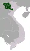 | |
| Hòa Bình Province | ||
| Lai Châu Province | ||
| Lào Cai Province | ||
| Sơn La Province | ||
| Yên Bái Province | ||
※ denotes provincial seat. | ||
This article is issued from Wikipedia. The text is licensed under Creative Commons - Attribution - Sharealike. Additional terms may apply for the media files.