Bagaduce River
The Bagaduce River is a tidal river in the Hancock County, Maine that empties into Penobscot Bay near the town of Castine. From the confluence of Black Brook and the outflow of Walker Pond (44°21′16″N 68°40′41″W), the river runs about 14 miles (23 km)[1] north, northwest, and southwest, forming the border between Brooksville on its left bank and Sedgwick, Penobscot, and Castine on its right.
| Bagaduce River | |
|---|---|
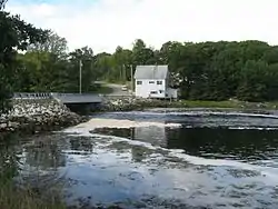 ME Route 175/176 crosses the Bagaduce River | |
| Location | |
| Country | United States |
| Physical characteristics | |
| Source | |
| • location | Maine |
| Mouth | |
• location | Penobscot Bay |
• coordinates | 44°22′37″N 68°48′50″W |
• elevation | sea level |
| Length | 14 miles (23 km) |
In 2014, residents of Penobscot raised concerns over the rapidly growing oyster farming on the Bagaduce River.[2]
See also
External links
References
- U.S. Geological Survey. National Hydrography Dataset high-resolution flowline data. The National Map Archived 2012-04-05 at WebCite, accessed June 22, 2011
- "Increased oyster farming on the Bagaduce River raises concerns for area residents". Bangor Daily News. Retrieved 4 August 2014.
- "Bagaduce River". Geographic Names Information System. United States Geological Survey. 30 September 1980. Retrieved 2010-05-18.
- Maine Streamflow Data from the USGS
- Maine Watershed Data From Environmental Protection Agency
This article is issued from Wikipedia. The text is licensed under Creative Commons - Attribution - Sharealike. Additional terms may apply for the media files.