Ellis River (Maine)
The Ellis River is a 23-mile-long (37 km)[1] river in Oxford County in western Maine. It is a tributary of the Androscoggin River.
This article is about the river in western Maine. For the river in the White Mountains of New Hampshire, see Ellis River (New Hampshire).

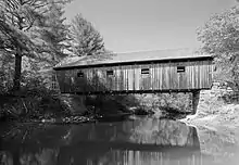
The Ellis River and the Lovejoy Bridge
The river begins at the outlet of Ellis Pond in the northwest corner of Roxbury and flows southwest via a meandering course into Andover, passing the village of East Andover before turning more to the southeast near South Andover. The river enters the corporate limits of Rumford and joins the Androscoggin at the village of Rumford Point.
From South Andover to the river's mouth, the Ellis River is followed by Maine State Route 5. U.S. Route 2 crosses the river just above its outlet to the Androscoggin.
References
- U.S. Geological Survey. National Hydrography Dataset high-resolution flowline data. The National Map Archived 2012-04-05 at WebCite, accessed June 30, 2011
| Bay of Fundy |
| ||||||||||||||||||||||||||||||
|---|---|---|---|---|---|---|---|---|---|---|---|---|---|---|---|---|---|---|---|---|---|---|---|---|---|---|---|---|---|---|---|
| Casco Bay |
| ||||||||||||||||||||||||||||||
| Gulf of Maine |
| ||||||||||||||||||||||||||||||
| Merrymeeting Bay |
| ||||||||||||||||||||||||||||||
| Muscongus Bay |
| ||||||||||||||||||||||||||||||
| Penobscot Bay |
| ||||||||||||||||||||||||||||||
| Saco Bay |
| ||||||||||||||||||||||||||||||
This article is issued from Wikipedia. The text is licensed under Creative Commons - Attribution - Sharealike. Additional terms may apply for the media files.