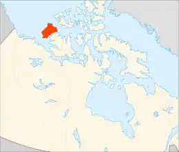
Banks Island
Banks Island is one of the larger members of the Arctic Archipelago. Situated in the Inuvik Region, and part of the Inuvialuit Settlement Region, of the Northwest Territories, it is separated from Victoria Island to its east by the Prince of Wales Strait and from the mainland by Amundsen Gulf to its south. The Beaufort Sea lies to its west, and to its northeast M'Clure Strait separates the island from Prince Patrick Island and Melville Island.
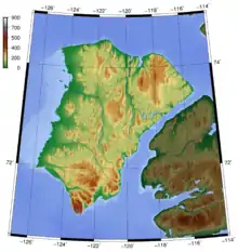
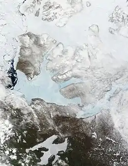 These moderate resolution imaging spectroradiometer images from June 14 and 16, 2002, show Banks Island (upper left) and Victoria Island (to the southeast) | |
 | |
 Banks Island  Banks Island | |
| Geography | |
|---|---|
| Location | Beaufort Sea |
| Coordinates | 72°45′02″N 121°30′10″W |
| Archipelago | Arctic Archipelago |
| Area | 70,028 km2 (27,038 sq mi) |
| Area rank | 24th |
| Length | 380 km (236 mi) |
| Width | 290 km (180 mi) |
| Highest elevation | 730 m (2400 ft) |
| Highest point | Durham Heights |
| Administration | |
Canada | |
| Territory | Northwest Territories |
| Largest settlement | Sachs Harbour (pop. 103) |
| Demographics | |
| Population | 103 (2016[1]) |
| Pop. density | 0.0016/km2 (0.0041/sq mi) |
It is home to at least fourteen mammal species including the Peary caribou, barren-ground caribou, and polar bears. At one time over 68,000 muskoxen lived on the island, the majority of the world's population. However, the bacterium Erysipelothrix rhusiopathiae has led to a sharp decline in their numbers. The island is the summer home to hundreds of thousands of migratory birds who nest at Banks Island Migratory Bird Sanctuary No. 1 and Banks Island Migratory Bird Sanctuary No. 2.[2][3]
As of the 2016 census it had a human population of 103, all in Sachs Harbour.[1]
Human settlements and discoveries
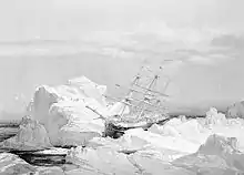
Pre-Dorset cultural sites have been found that date from approximately 1500 BCE but European contact came much later. In 1820 it was seen from Melville Island by Sir William Edward Parry and named "Banks Land" in honour of Sir Joseph Banks. However, during the later exploration of the area by the McClure Arctic Expedition the island was marked on their maps as "Baring Island".[4] McClure's ship, HMS Investigator, was frozen in Prince of Wales Strait. That spring he sent out sledging parties and determined that Banks Island was an island. In the following year he almost circumnavigated the island but was again frozen in at Mercy Bay where he and his crew spent the next three months before making their escape across the ice.[5]
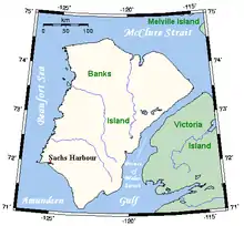
The only permanent settlement on the island is the Inuvialuit hamlet of Sachs Harbour (Ikhuak), on the southwest coast.
Description
Banks Island covers an area 70,028 km2 (27,038 sq mi) and it is the world's 24th largest island and Canada's fifth largest island. It is about 380 km (240 mi) long, and at its widest point at the northern end, 290 km (180 mi) across. The highest point of the island is in the south, Durham Heights and rises to about 730 m (2,400 ft).[6] It is part of the Canadian Arctic Archipelago, and had a population of 112 in 2011, all in Sachs Harbour.
Ecology
The island is treeless, with the tallest plant, the Arctic willow, growing occasionally to about the height of a person's knee but usually standing no taller than 10 cm (3.9 in).
Banks Island is home to two-thirds of the world's population of lesser snow geese, which make their way across the Amundsen Gulf from the mainland. There is an annual goose hunt in the spring out of Sachs Harbour. The island is part of the tundra world biome, which has extremely cold winters. The island is home to barren-ground caribou, polar bears, muskoxen, and birds, including year round residents the common raven and ptarmigan.
Two federal migratory bird sanctuaries were founded on the island in 1961.
Aulavik National Park of Canada, a fly-in park, protects about 12,274 km2 (4,739 sq mi) of Arctic lowlands at the northern end of the island.[7] The park has the highest concentration of muskoxen on earth, and is home to the endangered Peary caribou.[7] The Thomsen River runs through the park, and is the northernmost navigable river (by canoe) in North America. Ptarmigan and ravens are considered the only year-round birds in the park, although 43 species make seasonal use of the area. In Inuvialuktun, Aulavik means "place where people travel" and the "wildlife and land have supported aboriginal peoples for more than 3,400 years, from Pre-Dorset cultures to contemporary Inuvialuit."[7]
The first confirmed grizzly–polar bear hybrid found in the wild was shot on Banks Island in April 2006, near Sachs Harbour.
HMS Investigator
In July 2010, Parks Canada archaeologists looking for HMS Investigator found it 15 minutes after they started a sonar scan of Banks Island's Mercy Bay. The archaeology crew had no plans to raise the ship. They planned to conduct a thorough sonar scan of the area, then send a remotely operated vehicle.[8]
References
- "Census Profile, 2016 Census Sachs Harbour, Hamlet [Census subdivision], Northwest Territories and Northwest Territories [Territory]". 2016 Census. Statistics Canada.
- Banks Island Migratory Bird Sanctuary No. 1
- Banks Island Migratory Bird Sanctuary No. 2
- "Frozen Ocean Search for the North-West Passage". Ve.tpl.toronto.on.ca. Archived from the original on 2012-02-05. Retrieved 2012-05-29.
- Armstrong, Alexander (1857). A Personal Narrative of the Discovery of the Northwest Passage. London: Hurst and Blackett. Retrieved 2010-04-07.
- James Harley Marsh (March 4, 2015). "Banks Island". The Canadian Encyclopedia. Retrieved September 11, 2019.
- "Aulavik National Park of Canada", Parks Canada, 16 January 2014, retrieved 1 November 2014
- "Abandoned 1854 ship found in Arctic". CBC News. July 29, 2010. Retrieved February 26, 2012.
Further reading
- Canada. Banks Island, a Natural Area of Canadian Significance. Natural area of Canadian significance. Ottawa: Parks Canada, 1978.
- Cotter, R. C., and J. E. Hines. 2001. "Breeding Biology of Brant on Banks Island, Northwest Territories, Canada". Arctic. 54: 357–366.
- Gajewski, K, R Mott, J Ritchie, and K Hadden. 2000. "Holocene Vegetation History of Banks Island, Northwest Territories, Canada". Canadian Journal of Botany. 78: 430–436.
- Holyoak, D. T. Notes on the Birds of Southwestern Banks Island, Northwest Territories, Canada. Bulletin of the British Ornithologists' Club, Vol.103,No.2, June. 1983.
- Manning, T. H., E. O. Höhn, and A. H. Macpherson. The Birds of Banks Island. 1956.
- Stephens, L. E., L. W. Sobczak, and E. S. Wainwright. Gravity Measurements on Banks Island, N.W.T. Gravity map series, no. 150. Ottawa: Dept. of Energy, Mines and Resources, Earth Physics Branch, 1972.
- Stephenson, S.A. 2010. Fishes of the Thomsen River, Banks Island, Northwest Territories. Can. Manuscr. Rep. Fish. Aquat. Sci. 2944: vi + 44 p.
- Struzik, Ed. 2000. "AND THEN THERE WERE 84,000 – The Return of Musk-Oxen to Canada's Banks Island in Recent Decades Is Just One Chapter of a Beguiling Arctic Mystery". International Wildlife. 30, no. 1: 28.
- Will, Richard T. Utilization of Banks Island Muskoxen by Nineteenth Century Copper Inuit. [S.l.]: Boreal Institute for Northern Studies, 1983.
External links
- Historical sites of the Northwest Passage
- Chart of the Northwest Passage
- Banks Island at civilization.ca
- Banks Island Archaeological Site Early Dorset artifacts collected by the Prince of Wales Northern Heritage Centre, Northwest Territories, Canada.
| Authority control |
|---|