Somerset Island (Nunavut)
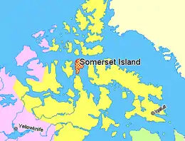
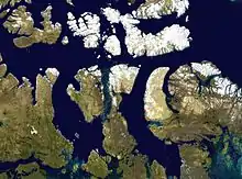
In the Canadian Arctic Archipelago, Somerset Island (Inuktitut Kuuganajuk) is a large, uninhabited island separated by the 2 km (1.2 mi) wide Bellot Strait from the Boothia Peninsula in the Qikiqtaaluk Region of Nunavut, Canada, lying between Peel Sound (across which lies Prince of Wales Island) and Prince Regent Inlet (across which lies Baffin Island). It has an area of 24,786 km2 (9,570 sq mi), making it the 46th largest island in the world and Canada's twelfth largest island.[1]
| Native name: Kuuganajuk | |
|---|---|
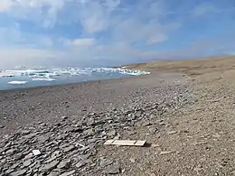 | |
 Somerset Island, Nunavut, Canada | |
| Geography | |
| Location | Northern Canada |
| Coordinates | 73°15′N 93°30′W |
| Archipelago | Canadian Arctic Archipelago |
| Area | 24,786 km2 (9,570 sq mi) |
| Area rank | 46th |
| Highest elevation | 489 m (1604 ft) |
| Highest point | Creswell Peak |
| Administration | |
Canada | |
| Territory | Nunavut |
| Region | Qikiqtaaluk |
| Demographics | |
| Population | Uninhabited |
History
Around 1000 AD, the north coast of Somerset Island was inhabited by the Thule people, as evidenced by whale bones, tunnels and stone ruins.
William Edward Parry was the first European to sight the island in 1819.[2]
HMS Fury was an arctic exploration ship commanded by Henry Parkyns Hoppner. She was damaged by ice while overwintering and was abandoned on 25 August 1825, at what has since been called Fury Beach on Somerset Island. Her stores were unloaded onto the beach and later came to the rescue of John Ross, who traveled overland to the abandoned cache when he lost his ship further south in the Gulf of Boothia on his 1829 expedition.
James Clark Ross was the nephew of John Ross, and accompanied him on the 1829 expedition. In late 1848, James Clark Ross returned to Somerset Island by landing two ships at Port Leopold on the northeast coast to winter. In April the following year, he launched an exploration of the island by sledge.
Roald Amundsen transited the passage between the Island and the Prince of Wales Island in the Gjøa in the first successful traverse of the Northwest Passage in 1904. Henry Larsen transited the passage, in the St Roch in the second successful transit in 1943. But he found this route was dangerously icebound, and also too shallow for commercial travel.
The Fort Ross trading post was established and run by the Hudson's Bay Company at the southeastern end of the island from 1937 to 1948. When it was closed, the island was left uninhabited except for occasional use of the former store and manager's house as shelters by Inuit caribou hunters from Taloyoak and a small settlement at Creswell Bay, which after 1967 consisted solely of the family of Timothy Idlout and Naomi Nangat.[3] The Idlout family left Somerset Island in 1991, leaving it completely uninhabited. In 2006, CBC's The National included Fort Ross in a special series focused on climate change.[4]
Tourism
Arctic Watch Lodge, a tourism establishment built in 1992, is located on Somerset Island. Arctic Watch was established at Cunningham Inlet because of the large number of beluga whales that congregate there in the summer. Arctic Watch Lodge is operated by Richard Weber and Josée Auclair.[5] There is a private airstrip at the site, Arctic Watch Lodge Aerodrome.[6]
References
- "Atlas of Canada - Sea Islands". Atlas.nrcan.gc.ca. 2009-08-12. Archived from the original on 2013-01-22. Retrieved 2010-08-30.
- Parry, William Edward (1821). Journal of a voyage for the discovery of a North-West passage from the Atlantic to the Pacific: performed in the years 1819-20. London: John Murray.
William Edward Parry 1819.
- Timothy Idlout (1916-92)
- "Northwest Passage: The National visits Canada's North". CBC News. 2006-10-27. Archived from the original on 2006-11-03. Retrieved 2008-08-14.CS1 maint: bot: original URL status unknown (link)
- About us
- Canada Flight Supplement. Effective 0901Z 16 July 2020 to 0901Z 10 September 2020.
Further reading
- Migratory Bird Population Surveys in the District of Keewatin and Somerset Island, 1976 - AIPP Preliminary Report 1977, 1978
- Canadian Oceanographic Data Centre. Stanwell-Fletcher Lake, Somerset Island, N.W.T, 1965-1966 CODC References: 07-65-002, 07-66-002, Ottawa, ON: Queen's Printer, 1968
- Dyke, Arthur S. (1983), Quaternary Geology of Somerset Island, District of Franklin, Ottawa, ON: Geological Survey of Canada, ISBN 0-660-11401-1
- Reinson, G. E. (1978), Carbonate-Evaporite Cycles in the Silurian Rocks of Somerset Island, Arctic Canada, Ottawa, ON: Energy, Mines and Resources Canada, ISBN 0-660-01512-9
- Savelle, James M.; Cultural and Natural Formation Processes of a Historic Inuit Snow Dwelling Site, Somerset Island, Arctic Canada, American Antiquity, Vol. 49, No. 3, 1984
- VanStone, James W.; Anderson, James E.; and Merbs, C. F.; An Archaeological Collection from Somerset Island and Boothia Peninsula, N.W.T, Toronto, ON, 1962
External links
- CBC.ca In Depth: Northwest Passage
- Somerset Island (Nunavut) in the Atlas of Canada - Toporama; Natural Resources Canada