Barnala, Azad Kashmir
Barnala (Urdu: برنالہ ) is a small city located in the state of Azad Kashmir, Pakistan.
Barnala
برنالہ | |
|---|---|
City | |
 Barnala  Barnala | |
| Coordinates: 32°52′14″N 74°14′51″E | |
| Country | |
| Territory | |
| Tehsil/Subdivision | Barnala |
| Established | 1996 AD |
| Elevation | 313 m (1,027 ft) |
| Population (2017)[1] | |
| • Total | 120,000 |
| Languages | |
| • Regional | Punjabi (Pahari,Gojri), Urdu, English |
| Time zone | UTC+5 (PST) |
| Postal code | 10020 |
| Dialling code | 0092-05828 |
| Website | Official Website |
The word Barnalas literally translates to Bar (Edge) and Nala (River), which means "on the edge of a river" and was a key location during the 1965 Battle of Chamb.
It serves as a tehsil (sub-division) of the district Bhimber, AJK.
Geography
Barnala is located on the banks of the Chenab River and is 43.9 km (via Awan Sharif-Fatehpur Road) northeast of Gujrat District of the Punjab Province in Pakistan.
The boundaries of Barnala are connected with Bhimber, Kotla Arab Ali Khan, Gujrat, Sialkot, and Jammu. It is 200 km southeast of Rawalpindi, 180 km southeast of Islamabad, 60 km northwest of Sialkot, and 100 km northwest of Jammu.
Topography
Topographically, Barnala is divided into four regions:
- Plain Region
- Mountain Region
- Hill Region
- Cliff Region
Demography
As per the 2017 Census of Pakistan,[2] the total population of the sub-division Barnala is approximately 120,000. The growth rate[3] is nearly 2.6% with an average household size of 6.7.
Education
The literacy rate is about 70% with several colleges located in and around the sub-division.
Economy
The area is known for its mango trees,[4] pine trees (صنوبر ،چیڑھ ) along with the cultivation and production of jujube (Ber: بیر ), mulberries(شہتوت), rice, sugar cane, bananas, mustard, millet and wheat.[5] Fine and coarse aggregate materials (sand and crush) are also produced for use in the construction industry. Stone dust, also known as Khaka, is used in place of sand for construction of temporary units and back-filling. Timber is also produced by this city.
Tourism
Pattni vale is a beautiful viewpoint for tourists and is situated near the LoC (Line of Control). Panjj Peer Darbar of village Amgah is a place that is mostly visited by Zaireen (Urdu: زائرین ) during Eid. The Mango Gardens of Watala, a historical site in Barnala, also attracts a wide range of tourists. Peer Monga Darbar is a place visited by Zaireen (Urdu: زائرین ) on a daily basis.
Landmarks
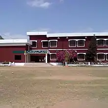
The central mosque of the city is the Bilal Masjid, while Muhammadi Masjid lies in the southeastern part of the city. The Barkat Plaza is the central shopping mall and is located on one of the main roads of the city. The Inter College for Boys Library and Girls Degree College are located in southwest Barnala.[6] A small park called the Barnala Qabaristan is in the northwest regions whereas Kot Jamel road leads across a bridge over the Chenab tributary to the eastern parts of the city. The eastern side of the city is also home to the Government Boys Degree College, Masjid Ahl-e-Hadis mosque, and the Tawaqal Sanitary.[7]
Union Councils
Tehsil Barnala consists of the following 7 union councils:
- Barnala
- Pattni (Thub)
- Pangali
- Watala
- Maloot
- North Iftikharabad (Chamb)
- South Iftikharabad (Chamb)
- ambriyala
References
- "Statistical Year Book 2019" (PDF). Statistics Azad Jammu and Kashmir. Retrieved 4 May 2020.
- "Pakistan - Census, Standards & Statistics". doi:10.1163/2213-2996_flg_com_323859. Cite journal requires
|journal=(help) - "Statistical Year Book 2019". International Year Book and Statesmen's Who's Who. Retrieved 11 May 2020.
- Sainik Samachar, Volume 17, Issues 1-26. 1970. p. 194.
- Indian and Foreign Review - Volume 15 (1977), p. 12.
- Directory of Libraries in Pakistan (1996), p.3
- Google. "Barnala, Azad Kashmir" (Map). Google Maps. Google. No URL entered.
| Mirpur |
| ||||||||
|---|---|---|---|---|---|---|---|---|---|
| Muzaffarabad |
| ||||||||
| Poonch |
| ||||||||