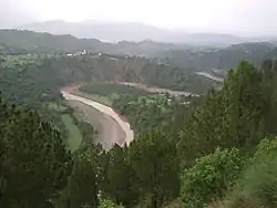
Kotli District
The Kotli District (Urdu: ضلع کوٹلی) is one of the 10 districts of Pakistan's dependent territory of Azad Kashmir. It is bounded on the north by the Sudhanoti District and the Poonch District, on the north-east by the Poonch District of Indian-administered Jammu and Kashmir, on the south by the Mirpur District and the Bhimber District, and on the west by the Rawalpindi District on Pakistan's Punjab Province. It is the biggest district of Azad Kashmir by population and the second biggest by land area, after the Neelum District. The district headquarters is the city of Kotli.[2] Other prominent towns are Khuiratta, Nakyal, Sehnsa, and Tatta Pani.
Kotli District
ضلع کوٹلی | |
|---|---|
 | |
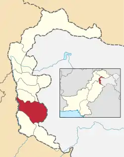 Map of Azad Kashmir with the Kotli District highlighted in red | |
| Sovereign state | |
| Dependent territory | |
| Division | Mirpur Division |
| Headquarters | Kotli |
| Area | |
| • Total | 1,862 km2 (719 sq mi) |
| Population (2017) | |
| • Total | 774,194[1] |
| • Density | 416/km2 (1,080/sq mi) |
| Number of tehsils | 5 |
Administrative divisions
The Kotli District was previously a subdivision of the Mirpur District until 1975. Before 1947, it was part of the Jammu area of Jammu and Kashmir. The district is divided into five tehsils:[3]
Education
According to the Pakistan District Education Ranking 2017, a report by Alif Ailaan, the Kotli District stands at number 7 nationally relating to education, with a score of 73.68. The learning score stands at 85.67 and gender parity is at 93.45.[4]
According to the same report, the Kotli District is ranked at 119 nationally, with a learning score of 35.47 and a retention score of 35.36.[4] The learning score is low because of a lack of quality teachers and proper teacher training. The retention score is low because of the low number of beyond-primary schools.
With regard to infrastructure, the Kotli District stands at 154, with a score of 14.14, which is the second lowest in Pakistan and its two dependent territories. [4] That score shows that there is a serious problem with the lack of basic facilities such as electricity, functional toilets, furniture, and boundary walls.
See also
References
- "Azad Jammu & Kashmir At A Glance 2017" (PDF). pndajk.gov.pk. Planning & Development Department AJ&K. Retrieved 15 November 2019.
- Azad Kashmir government website
- "Tehsils of Kotli District on AJK map". ajk.gov.pk. AJK Official Portal. Retrieved 17 November 2019.
- "Pakistan District Education Rankings 2017" (PDF). elections.alifailaan.pk. Alif Ailaan. Retrieved 18 November 2019.
External links
- Azad Jammu and Kashmir Govt. Kotli page
 Azad Jammu and Kashmir travel guide from Wikivoyage
Provincial capital: Muzaffarabad | ||
| Muzaffarabad | 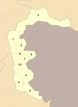 | |
| Poonch | ||
| Mirpur | ||