Rawalakot
Rawalakot (Urdu: راولا کوٹ ) is the capital of Poonch district in Azad Kashmir, Pakistan. It is located in the Pir Panjal Range.
Rawalakot
راولا کوٹ | |
|---|---|
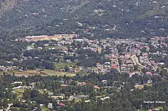 A view of Rawalakot | |
 Rawalakot  Rawalakot | |
| Coordinates: 33°51′12″N 73°45′05″E | |
| Country | Pakistan |
| Administrative Territory | Azad Kashmir |
| District | Poonch District |
| Area | |
| • Total | 1,010 km2 (390 sq mi) |
| Elevation | 1,638 m (5,374 ft) |
| Population (2017)[1] | |
| • Total | 56,006 |
| • Estimate (2018) | 56,590 |
| • Density | 375/km2 (970/sq mi) |
| Time zone | UTC+5 (PST) |
| Calling code | 05824 |
| Number of towns | 3 |
| Number of Union councils | 21 |
Location
Rawalakot is located at Latitude 33°51'32.18"N, Longitude 73° 45'34.93"E and an Elevation of 5374 feet. Rawalakot is approximately 76 kilometres (47 mi) from Kahuta and about 120 km (75 mi) from the city of Rawalpindi, Pakistan. It is linked with Rawalpindi and Islamabad via Goyain Nala and Tain roads. Via Kotli Satiyan and Kahuta. It is also linked with Rawalpindi via Sudhnuti.
Transport
Travel routes
Construction of the Ghazi-e-Millat road (also known as Guoien Nala road) between Rawalakot and Azad Pattan has considerably reduced travel time, it is main road which is connecting Islamabad/Rawalpindi to Rawalakot city. A bus across the LOC, the Poonch-Rawalakot bus has helped to re-establish ties across the conflict torn region.
Road links
The road passing through Pakgali-Paniola connects Rawalakot to Bagh, Rawalpindi and Muzaffarabad. The other road that passes through Mohri Farman Shah, Shuja Abad is the shortest possible road link that connects Rawalakot city with Bagh. Murree, Islamabad and Rawalpindi are in a southward direction from Rawalakot. The town has another road link with Kotli.
Rawalakot Airport is non-operational, the airport has been closed since 1998.
Climate
Rawalakot features a subtropical highland climate under the Köppen climate classification due to high altitude. Rawalakot's weather is quite erratic. However, the climate of Rawalakot can be divided into four seasons, namely spring, summer, autumn and winter. Rawalakot has mild to warm temperatures during the spring and autumn, humid temperatures during the summer and cold to snowy during the winter. The temperature can rise as high as 38 °C (100 °F) during the mid-summer months and drop below −1 °C (30 °F) during the winter months. Snowfall occurs in December and January, while most rainfall occurs during the monsoon season stretching from July to September.[2]
| Climate data for Rawalakot, Azad Kashmir | |||||||||||||
|---|---|---|---|---|---|---|---|---|---|---|---|---|---|
| Month | Jan | Feb | Mar | Apr | May | Jun | Jul | Aug | Sep | Oct | Nov | Dec | Year |
| Record high °C (°F) | 25.6 (78.1) |
32.9 (91.2) |
34.4 (93.9) |
41.0 (105.8) |
45.0 (113.0) |
46.6 (115.9) |
43.2 (109.8) |
40.0 (104.0) |
39.4 (102.9) |
39.9 (103.8) |
33.3 (91.9) |
28.9 (84.0) |
46.6 (115.9) |
| Average high °C (°F) | 17.3 (63.1) |
19.8 (67.6) |
24.7 (76.5) |
30.6 (87.1) |
36.3 (97.3) |
38.1 (100.6) |
34.8 (94.6) |
33.5 (92.3) |
33.2 (91.8) |
30.4 (86.7) |
25.2 (77.4) |
19.7 (67.5) |
28.6 (83.5) |
| Average low °C (°F) | 3.8 (38.8) |
6.7 (44.1) |
11.1 (52.0) |
15.9 (60.6) |
21.0 (69.8) |
23.8 (74.8) |
24.3 (75.7) |
23.6 (74.5) |
21.1 (70.0) |
14.8 (58.6) |
8.8 (47.8) |
5.0 (41.0) |
15.0 (59.0) |
| Record low °C (°F) | −2.6 (27.3) |
0.0 (32.0) |
2.8 (37.0) |
3.3 (37.9) |
10.0 (50.0) |
13.0 (55.4) |
12.0 (53.6) |
12.7 (54.9) |
13.0 (55.4) |
1.9 (35.4) |
0.0 (32.0) |
−3.3 (26.1) |
−3.3 (26.1) |
| Average rainfall mm (inches) | 24.9 (0.98) |
30.8 (1.21) |
31.2 (1.23) |
20.1 (0.79) |
14.4 (0.57) |
44.1 (1.74) |
112.8 (4.44) |
136.3 (5.37) |
43.8 (1.72) |
15.7 (0.62) |
14.5 (0.57) |
19.1 (0.75) |
507.7 (19.99) |
| Source: [3] | |||||||||||||
Demography
Rawalakot has an urban population of 56,006 people according to the 2017 census which rose to 56,590 in 2018.[1]
2005 Kashmir earthquake
On Saturday, 8 October 2005[4] a 7.6 magnitude earthquake killed 73,338 people and left up to three million homeless in Pakistan, including Azad Kashmir. The city of Rawalakot, the capital of the Poonch, suffered significant damage from the 2005 Kashmir earthquake; although most of the buildings were left standing, many of them were rendered uninhabitable, and some of the population was left homeless. Most of the buildings have been reconstructed.

References
- "Statistical Year Book 2019" (PDF). Statistics Azad Jammu and Kashmir. Retrieved 20 April 2020.
- Pakistan Meteorological Department Kaleem Abbasi, 15 Aug, 2014 Archived 20 January 2012 at the Wayback Machine
- "Rawalakot, Azad Kashmir". Climate Charts. Retrieved 14 June 2013.
- "Earth Quake 2005". Drgeorgepc.com. Retrieved 1 October 2012.
External links
 Azad Jammu and Kashmir travel guide from Wikivoyage
- Britannica – Azad Kashmir
- World atlas page about Azad Kashmir status
| Mirpur |
| ||||||||
|---|---|---|---|---|---|---|---|---|---|
| Muzaffarabad |
| ||||||||
| Poonch |
| ||||||||
