Bayburt
Bayburt is a city in northeast Turkey lying on the Çoruh River and is the provincial capital of Bayburt Province.
Bayburt
Bayburt | |
|---|---|
.jpg.webp) | |
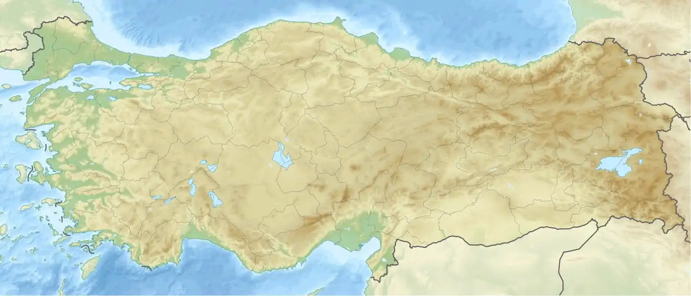 Bayburt Location within Turkey  Bayburt Location within Europe .svg.png.webp) Bayburt Bayburt (Earth) | |
| Coordinates: 40°15′35″N 40°13′40″E | |
| Country | Turkey |
| Region | Black Sea |
| Province | Bayburt |
| Government | |
| • Mayor | Hükmü Pekmezci (MHP) |
| • Governor | Cüneyt EPCİM |
| Area | |
| • District | 2,655.41 km2 (1,025.26 sq mi) |
| Elevation | 1,550 m (5,090 ft) |
| Population (2012)[2] | |
| • Urban | 35,947 |
| • District | 61,354 |
| • District density | 23/km2 (60/sq mi) |
| Time zone | UTC+3 (TRT) |
| Postal code | 69xxx |
| Area code(s) | 458 |
| Vehicle registration | 69 |
| Website | Municipality Provincial Government |
Bayburt was once an important center on the ancient Silk Road. It was visited by Marco Polo and Evliya Çelebi. Remains of its medieval castle still exist. There are several historical mosques, Turkish baths, and tombs in the city. There are also ancient historical sites such as the Çatalçeşme Underground Complex and natural wonders like the Sirakayalar Waterfall in the other parts of the province.
Name
The name of the town was formerly written in Ottoman Turkish as بايبورد (Bayburd)[3] and in English as Baiburt.[4][5] It was known as Paipert under the Byzantines. The name derives from the medieval Armenian Baydbert (Բայտբերդ), which derives from its ancient name Ambatavan (Ամբատավան).
History
.jpg.webp)
.jpg.webp)
Bayburt straddles the Çoruh amid an open and fertile plateau on the route between Trabzon and Erzurum.[5] It was founded by the Azzi people. It was subsequently settled or conquered by the Cimmerians in the 8th century BC, the Medes in the 7th century BC, then the Persians, Pontus, Rome, the Byzantines, the Bagratid Armenian Kingdom, the Seljuk Turks, the Aq Qoyunlu, Safavid Persia, and then the Ottoman Turks.
The town was the site of an Armenian fortress in the 1st century and may have been the Baiberdon fortified by the emperor Justinian.[4] It was a stronghold of the Genovese in the late Middle Ages[4] and prospered in the late 13th and early 14th century because of the commerce between Trebizond and Persia.[6] It contained a mint under the Seljuks and Ilkhanids.[6] From c. 1243 to 1266, Bayburt was under brief control of the Georgian princes of Samtskhe. A Christian church within the Bayburt castle was built in the 13th century under the Trapezuntine or Georgian influence.[7]
Under Ottoman rule, the town was the center of the Bayburt Sanjak in Erzurum Eyalet. When Erzurum was devastated in the early 16th century, Bayburt served for a time as the de facto capital of the province.[6] The area was raided by the Safavids in 1553. Bayburt was captured by a Russian army under General Paskevich[5] and its fortifications thoroughly demolished in 1829.[4] It was the furthest westward reach of the Russians during that campaign.[5] The British traveller William John Hamilton commented on the ruins in the 1840s,[8] though the population grew to 6000 by the 1870s.[4] The bazaar, however, remained poor and the town long lacked industry.[5] Prior to the First World War, the population of 10,000 was mostly Turkish with some Armenians.[5]
According to the Qamus al-A'lam (Qāmūsu'l-aˁlām/قاموس الأعلام, “Dictionary of the World”) of Shemseddin Sami, Sanjak of Bayburt, comprising four kazas called Ispir, Şiran, Kelkit and Bayburt itself, had 505 villages and 40 nahiyes. The sanjak had a population of 124019 people. 108373 people of the population was Turkish and Muslim, and the rest of the population was Christian, predominantly Armenian.
Inside the Sanjak of Bayburt there were said to be 292 mosque and masjid, 176 madrasah, 87 church and monastery, 2 middle school (rushdiye), 108 primary school (sıbyan mektebi).[9]
Climate
Bayburt has a continental climate with freezing cold winters and heavy snow. Summers are warm with cool nights. The climate is humid continental under the Köppen Climate System. Most of the precipitation occurs in late spring and early summer. The lowest temperature recorded was -31.3 °C (-24.3 °F) in January 1972. The highest temperature recorded was 37.1 °C (98.8 °F) in August 2006. The highest snow thickness recorded was 110 cm (43.3 inches) in March 1976.
| Climate data for Bayburt (1960-2012) | |||||||||||||
|---|---|---|---|---|---|---|---|---|---|---|---|---|---|
| Month | Jan | Feb | Mar | Apr | May | Jun | Jul | Aug | Sep | Oct | Nov | Dec | Year |
| Record high °C (°F) | 10.3 (50.5) |
13.9 (57.0) |
21.2 (70.2) |
25.3 (77.5) |
29.6 (85.3) |
32.4 (90.3) |
36.2 (97.2) |
37.1 (98.8) |
33.3 (91.9) |
28.8 (83.8) |
20.0 (68.0) |
18.2 (64.8) |
37.1 (98.8) |
| Average high °C (°F) | −1.3 (29.7) |
0.2 (32.4) |
5.4 (41.7) |
12.7 (54.9) |
18.0 (64.4) |
22.4 (72.3) |
26.9 (80.4) |
27.3 (81.1) |
23.3 (73.9) |
16.7 (62.1) |
8.6 (47.5) |
1.7 (35.1) |
13.5 (56.3) |
| Daily mean °C (°F) | −6.5 (20.3) |
−5.3 (22.5) |
0.0 (32.0) |
7.0 (44.6) |
11.7 (53.1) |
15.4 (59.7) |
19.0 (66.2) |
18.8 (65.8) |
14.7 (58.5) |
9.2 (48.6) |
2.6 (36.7) |
−3.2 (26.2) |
7.0 (44.5) |
| Average low °C (°F) | −10.9 (12.4) |
−9.8 (14.4) |
−4.5 (23.9) |
1.7 (35.1) |
5.5 (41.9) |
8.2 (46.8) |
11.0 (51.8) |
10.8 (51.4) |
7.1 (44.8) |
3.4 (38.1) |
−1.9 (28.6) |
−7.1 (19.2) |
1.1 (34.0) |
| Record low °C (°F) | −31.3 (−24.3) |
−27.6 (−17.7) |
−28.3 (−18.9) |
−12.7 (9.1) |
−4.4 (24.1) |
−1.6 (29.1) |
0.2 (32.4) |
2.4 (36.3) |
−2.1 (28.2) |
−10.6 (12.9) |
−23.6 (−10.5) |
−29.0 (−20.2) |
−31.3 (−24.3) |
| Average precipitation mm (inches) | 26.5 (1.04) |
28.2 (1.11) |
39.7 (1.56) |
62.8 (2.47) |
68.6 (2.70) |
52.0 (2.05) |
20.6 (0.81) |
14.2 (0.56) |
20.7 (0.81) |
44.4 (1.75) |
34.2 (1.35) |
28.8 (1.13) |
440.7 (17.34) |
| Average precipitation days | 11.2 | 10.9 | 12.4 | 13.9 | 15.4 | 10.5 | 5.1 | 4.3 | 4.7 | 8.7 | 9.1 | 10.7 | 116.9 |
| Source: Devlet Meteoroloji İşleri Genel Müdürlüğü [10] | |||||||||||||
Sights
.jpg.webp)
Nature
Bayburt has several parks and open spaces like ''Aslan dağı Ormanı '' (Lion Mount Forest ) "Gençlik Parkı" (Youth Park), "Şehit Nusret Bahçesi" (Martyr Nusret Gardens), and "Yenişehir Parkı" meaning "New City Park". The city has 535.780 m2 (5,767.09 sq ft) of nursery areas, where young plants are raised for the forests of Bayburt. Also there are two caves that visitors can see the interesting natural shapes of the stones. These caves are, "Çimağıl Cave" and "Helva Village Ice Cave".
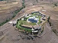
Castle

Bayburt Castle stands on the steep rocks north of Bayburt. It was held by the Bagratuni Dynasty in the 9th, 10th, and 11th centuries. It was completely rebuilt by the Saltuk ruler Mugis-al-Din Tugrul Sah between 1200 and 1230, as attested by an inscription in the walls of the castle. The massive size of its walls and the quality of its masonry place it amongst the finest of all the castles in Anatolia but for its destruction by the Russians[6] during the early nineteenth century.[11] Rebuilding was done during the Ottoman period.[6] The castle was inhabited till the destruction[6] of 1829.[5]
Aydıntepe Underground City
Located 45 km (28 mi) from Bayburt, the site consists of rock-cut galleries, vaulted rooms and wider spaces excavated out of natural rock, without using any building material within 2–2.5 metres (6 ft 7 in–8 ft 2 in) from the surface in the tuff. Vaulted galleries about one meter wide and 2 to 2.5 meters tall are expanding on both sides.[12]
The Dome of Dede Korkut
It is approximately 30 kilometres (19 mi) far from Bayburt, and locates in Masat Village.[13] It is located in the middle of Masat Village graveyard, has been hosting plenty of people from many countries including Turkic countries because of Dede Korkut Culture and Art Festival since 1995, and it is held every July. The dome, also known as Ali Baba and Korkut Ata, was restored in 1994, and it was released to the public. It has gained importance after has been included in the Representative List of the Intangible Cultural Heritage of Humanity of UNESCO in November 2018.[14]
Museum
Baksı Museum
The Baksı Museum stands near the Black Sea, 45 km (28 mi) from Bayburt on a hilltop overlooking the Çoruh Valley. Rising in what used to be called Baksı and is now the village of Bayraktar, this unusual museum offers contemporary art and traditional handicrafts side by side under one roof.[15]
Sports
Kop Mountain Ski Resort
Winter tourism center of this city. Far away 40 km in city center.
Football
There is a professional football stadium in the city and many private artificial surface sites.
The local football club in Bayburt is Bayburt Özel İdarespor, which currently competes in the TFF Second League.[16]
Şalcilarspor played in the third League between 1986 and 1988.
Swimming
There are many indoor swimming pools in the city.
Semi-Olympic swimming pool
The city center is opposite the Yenişehir Park. The pool water is kept at the same level in summer and winter so that the users can enjoy the pool in the best possible way. This pool have standard Semi-olympic swimming pool. Pool measures 12,5 meters X 25 meters and has a depth of 2 meters.
Education
Bayburt University
Bayburt University is located at the center of the city, the university has several faculties such as Engineering, Arts and Sciences, and Administrative Sciences. There are also several vocational schools.
Transportation
"Bayburt Otobus Terminali", located in the south of the city, is the main port to Bayburt.
Notable people
- İrşadi Baba (folk poet) (1879-1958)[17]
- Suat Türker
- Dede Korkut
- Bayburtlu Kara Ibrahim Pasha
- Hovhannes XI (Çamaşırciyan) (Armenian Patriarch of Constantinople between 1800 and 1801)
- Krikor Amirian
- Lütfü Silo [18][19]
- Selim Genç[20]
- Mustafa Yeneroğlu[21]
- Berhan Şimşek[22]
- Hakan Çalhanoğlu
- Vasip Şahin
- Naci Ağbal
- Namık Kemal Zeybek
- Serdar Orçin
- Baybutlu Zihni
Twin cities
Bayburt is twinned with:
See also
- Bayburt Museum of Modern Arts
- Şehit Osman Hill
- Arpalı Kasabası
Notes
- "Area of regions (including lakes), km²". Regional Statistics Database. Turkish Statistical Institute. 2002. Retrieved 2013-03-05.
- "Population of province/district centers and towns/villages by districts - 2012". Address Based Population Registration System (ABPRS) Database. Turkish Statistical Institute. Retrieved 2013-02-27.
- Miroğlu, İsmet. "BAYBURT". TDV İslâm Ansiklopedisi. Archived from the original on 7 June 2020. Retrieved 1 July 2020.
- EB (1878).
- EB (1911).
- Sinclair, T.A. (1989). Eastern Turkey: An Architectural & Archaeological Survey, Volume I. Pindar Press. pp. 284–289. ISBN 9780907132325.
- Peacock, Andrew (2012). "Between Georgia and the Islamic world: the atabegs of Samc'xe and the Turks". In Beyazit, Deniz (ed.). At the Crossroads of Empires: 14th-15th century Eastern Anatolia. Varia Anatolica. 25. Paris and Istanbul: Institut français d'études anatoliennes. pp. 49–70. ISBN 978-2-36245-002-0.
- Hamilton, William John (1842). Researches in Asia Minor, Pontus, and Armenia. Murray. pp. 231–233..
- Frashëri, (Shemseddin) Sami (1896). Kamus-ül alâm: tarih ve coğrafya lûgati ve tabir-i esahhiyle kâffe-yi esma-yi hassa-yi camidir (قاموس الأعلام). Istanbul: Mihran Matbbası.
- "İl ve İlçelerimize Ait İstatistiki Veriler- Meteoroloji Genel Müdürlüğü". Dmi.gov.tr. 1996-10-25. Archived from the original on 30 April 2011. Retrieved 2011-03-20.
- David Winfield, "A Note on the South-Eastern Borders of the Empire of Trebizond in the Thirteenth Century", Anatolian Studies, 12 (1962), p. 166
- "Aydıntepe Yeraltı Şehri". www.aydintepeyeraltisehri.com. Retrieved 2016-12-06.
- "DEDEKORKUT". www.bayburt.gov.tr. Retrieved 2020-07-01.
- https://plus.google.com/+UNESCO (2018-11-28). "Intangible Heritage: Nine elements inscribed on Representative List". UNESCO. Retrieved 2020-07-01.
- "Baksı Müzesi". en.baksi.org. Retrieved 2016-12-06.
- http://www.tff.org/Default.aspx?pageId=535&kulupID=153
- Sözlüğü, Türk Edebiyatı İsimler. "AĞLAR BABA/BAKİ/BAKİ BABA/AĞLAR/AĞLAR GÜLMEZ/İRŞÂDÎ, İrşâdî". teis.yesevi.edu.tr. Retrieved 2020-07-01.
- iha.com.tr. "ANADOLU YAKASI BAYBURT KÜLTÜR VE YARDIMLAŞMA DERNEĞİ GENEL BAŞKANI LÜTFÜ SİLO BGC Yİ ZİYARET ETTİ". İhlas Haber Ajansı (in Turkish). Retrieved 2020-07-01.
- www.selimgenc.com.tr
- "Mustafa Yeneroğlu" (in Turkish). Retrieved 2020-07-01.
- "BERHAN ŞİMŞEK". www.berhansimsek.com. Retrieved 2020-07-01.
References
| Wikimedia Commons has media related to Bayburt. |
- Baynes, T. S., ed. (1878), , Encyclopædia Britannica, 3 (9th ed.), New York: Charles Scribner's Sons, p. 240
- Maunsell, Francis Richard (1911), , in Chisholm, Hugh (ed.), Encyclopædia Britannica, 3 (11th ed.), Cambridge University Press, p. 214
Bayburt in Bayburt Province of Turkey | |||||||||||||||||||||||||||
|---|---|---|---|---|---|---|---|---|---|---|---|---|---|---|---|---|---|---|---|---|---|---|---|---|---|---|---|
| Districts | 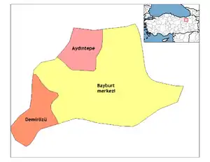 Districts of Bayburt | ||||||||||||||||||||||||||
| |||||||||||||||||||||||||||
Metropolitan municipalities are bolded. | |||||||||||||||||||||||||||