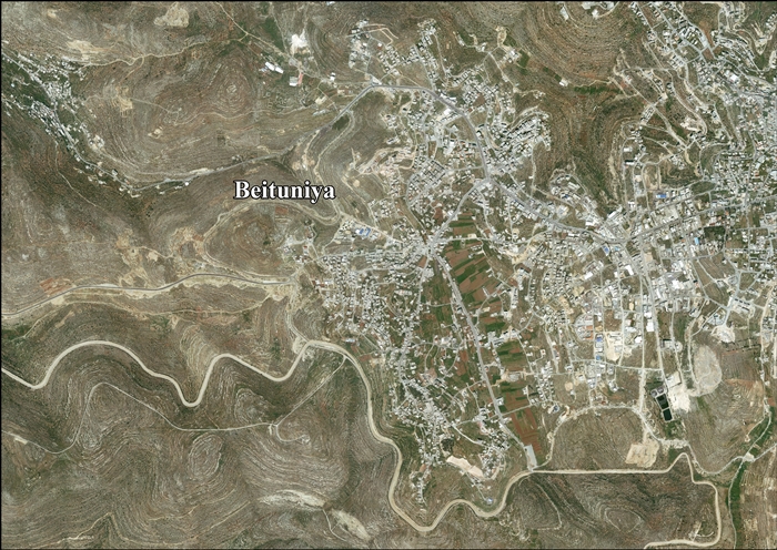
Beitunia
Beitunia (Arabic: بيتونيا), also Bitunya, is a Palestinian city located 3 kilometers (1.9 mi) west of Ramallah and 14 kilometers (8.7 mi) north of Jerusalem. The city is in the Ramallah and al-Bireh Governorate in the central West Bank. According to the Palestinian Central Bureau of Statistics, the city had a population of 19,761 in 2007,[3] making it the third largest locality in its governorate after al-Bireh and Ramallah.
Beitunia | |
|---|---|
| Arabic transcription(s) | |
| • Arabic | بيتونيا |
| • Latin | Beituniya (official) Beatonia (unofficial) |
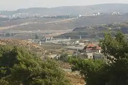 View of the city from the west | |
Municipal Seal of Beitunia | |
 Beitunia Location of Beitunia within Palestine | |
| Coordinates: 31°53′20″N 35°10′03″E | |
| Palestine grid | 166/143 |
| State | State of Palestine |
| Governorate | Ramallah and al-Bireh |
| Government | |
| • Type | Municipality |
| • Head of Municipality | Ribhi Dola |
| Area | |
| • Municipality type B | 26,174 dunams (26.2 km2 or 10.1 sq mi) |
| Population (2017)[1] | |
| • Municipality type B | 26,604 |
| • Density | 1,000/km2 (2,600/sq mi) |
| • Metro | 153,237 |
| Name meaning | Beitunia, personal name[2] |
| Website | www.beitunia.ps |
History
Potsherds from the Byzantine, Mamluk and early Ottoman period have been found.[4]
In 1883, the PEF's Survey of Western Palestine suggested that Beitunia was the Crusader village Uniet, which was one of 21 villages given by King Godfrey as a fief to the Church of the Holy Sepulchre.[5] However, in 1887, Röhricht identified Beitunia with Beitiumen, another fief given by the King to the Holy Sepulchre.[6][7] Conder found this to be "evidently correct" and hence "very doubtful" that Beitunia was Uniet.[8] Abel, writing in 1931, suggested that Beitunia was Beit Uniet, mentioned in an early 12th-century text.[4]
A large vaulted building in the town, named Badd al Balad ("oil press of the village") has been dated to the Crusader era.[9][10]
Ottoman era
Beitunia, like the rest of Palestine, was incorporated into the Ottoman Empire in 1517, and in the census of 1596, the village was located in the Nahiya of Quds of the Liwa of Quds. The population was 75 households and 5 bachelors, all Muslim. They paid a fixed tax rated of 33,3% on wheat, barley, olives, vineyards, fruit trees, goats and/or beehives, in addition to occasional revenues; a total of 23,000 akçe.[11]
In 1738 Richard Pococke called it "a place called Bethany to the north."[12]
The American scholar Edward Robinson noted it in 1838,[13] as a Muslim village, part of the El-Kuds district.[14]
In 1870 the French explorer Victor Guérin found that Beitunia contained six hundred inhabitants.[15] Socin found from an official Ottoman village list from about the same year (1870) that Beitunia had a total of 147 houses and a population of 481, though the population count included men, only.[16][17]
Several inscriptions, dating to 1873-74 and forwards, have been described from the house of the village Mukhtar.[18]
In 1883, the PEF's Survey of Western Palestine described Beitunia as "A good-sized village of stone, surrounded by olives, standing high on a flat rocky ridge, with a plain to the east. To the east are cisterns, wine-presses, and a pond (el Baliia), which contains water in winter. On the north and east are rock-cut tombs with well-cut entrances, but blocked up."[19]
In 1896 the population of Betunja was estimated to be about 1,056 persons.[20]
British Mandate era
In the 1922 census of Palestine conducted by the British Mandate authorities, Beitunia had a population of 948 Muslim,[21] increasing in the 1931 census to 1,213, still all Muslim, in 277 houses.[22]
Due to a lack of economic opportunities in the early 20th century, many people emigrated. Some went to the Chicago area, and were involved in the startup of the Bridgeview Mosque.[23][24]
In the 1945 statistics the population was 1,490, all Muslims,[25] while the total land area was 23,366 dunams, according to an official land and population survey.[26] Of this, 7,854 were allocated for plantations and irrigable land, 8,381 for cereals,[27] while 77 dunams were classified as built-up areas.[28]
Jordanian era
In the wake of the 1948 Arab–Israeli War, and after the 1949 Armistice Agreements, Beitunia came under Jordanian rule.
In 1961, the population of Beituniya was 2,216.[29]
Post-1967
Since the Six-Day War in 1967, Beitunia has been under Israeli occupation. After 1995, under the Oslo Accords, 3,759 dunums (17.8%) of the town's lands were classified as Area A, 472 dunums (2.2%) were classified as Area B, while the remaining 16,896 dunums (80%) were classified as Area C. Israel has confiscated land from Beitunia in order to construct two Israeli settlements: Beit Horon and Giv'at Ze'ev.[30][31]
According to the Oslo Accords, the IDF is prevented from entering areas A (an area under full Palestinian Authority control), but Operation Defensive Shield in 2002 abolished this distinction when the IDF searched that year in Beitunia for a suspect who wanted to make himself a "martyr."[32] The IDF-search extended to Qalandiya, Bayt Surik, Bayt Deko, al-Judeirah, and Hizma.
Separation barrier
Beitunia's land area consists of 2, 617.4 hectares (26,174 dunams) of which 336.2 hectares is built-up area. The Israeli West Bank barrier separates the urban area from 66% of the town's lands, however, most of the cut-off territory (Seam Zone) is made-up of forest and open spaces making it prime agricultural and grazing land.[33]
Salah El-Dein Mosque
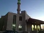
Salah El-Dein Mosque is located to the west of the city and was established in 2002. It is named related to the old Muslim leader Salah Al-Dein Al-Ayoubi. It is considered one of the main mosques in the area. It consists of 3 floors and has a capacity for approximately 500 persons.
Killed during Israeli Palestinian conflict
Fadel Abu Zahira (9 years old) was shot and killed on 18 April 2002 in his own home in Beitunia. The bullet came from an armored vehicle and went through the window. Hussein Mahmoud 'Awad 'Alian (17 years old) was killed by Israeli gunfire on 16 April 2004 during demonstrations against the barrier.[34]
Two boys, Nadim Nawarah and Mohammad Odeh, were shot and killed in the Beitunia killings on 15 May 2014. One Israeli policeman was arrested for Nawarah's death,[35] and was later under a plea deal sentenced to 9 months in jail.[36][37]
References
- "Main Indicators by Type of Locality - Population, Housing and Establishments Census 2017" (PDF). Palestinian Central Bureau of Statistics (PCBS). Retrieved 2021-01-19.
- Palmer, 1881, p. 287
- 2007 PCBS Census. Palestinian Central Bureau of Statistics. p.114.
- Finkelstein et al, 1997, pp. 346-7
- Conder and Kitchener, 1883, SWP III, p. 11
- Röhricht, 1887, p. 205
- de Roziére, 1849, pp. 98, 102: Beituimen; both cited in Röhricht, 1893, RRH, pp. 16- 17, No 74
- Conder, 1890, pp. 30, 32
- Pringle, 1997, p. 29
- Pringle, 2009, pp. 235-240
- Hütteroth and Abdulfattah, 1977, p. 121
- Pococke, 1745, vol 2, p. 49 NB "east" is probable typo for "west"
- Robinson & Smith, 1841, vol 2, pp. 133, 135
- Robinson and Smith, 1841, vol 3, Appendix 2, p. 121
- Guérin, 1875, p. 46
- Socin, 1879, p. 144 It was also noted to be in the El-Kuds district
- Hartmann, 1883, p. 127 noted 148 houses
- Sharon, 1999, p. 240 ff
- Conder and Kitchener, 1883, SWP III, p. 8
- Schick, 1896, p. 121
- Barron, 1923, Table VII, Sub-district of Ramallah, p. 16
- Mills, 1932, p. 48.
- Hard-liners won battle for Bridgeview mosque, February 8, 2004 Chicago Tribune
- Forget Poles: Palestinians find a home in suburban Chicago Archived 2016-02-05 at the Wayback Machine, February 7, 2013, webz.org
- Government of Palestine, Department of Statistics, 1945, p. 26
- Government of Palestine, Department of Statistics. Village Statistics, April, 1945. Quoted in Hadawi, 1970, p. 64
- Government of Palestine, Department of Statistics. Village Statistics, April, 1945. Quoted in Hadawi, 1970, p. 111
- Government of Palestine, Department of Statistics. Village Statistics, April, 1945. Quoted in Hadawi, 1970, p. 161
- Government of Jordan, Department of Statistics, 1964, p. 15
- Betunia: A Palestinian Community, POICA
- Beituniya Town Profile, ARIJ, pp. 17-18
- Nahum Barnea, 'Beitunian nights: The IDF in the West Bank', Ynet 18 March 2016.
- Betunia: A Palestinian Community Victimized by the Israeli Colonization Activities Archived December 15, 2007, at the Wayback Machine Applied Research Institute - Jerusalem 2007-11-11.
- Palestinian minors killed by Israeli security forces in the West Bank, before Operation "Cast Lead" B'Tselem.
- Israeli policeman arrested in Palestinian teen's death, CNN
- Even forensics can't stop Palestinian teen's killer walking free, Brad Parker
- Israeli cop sentenced to 9 months for killing Palestinian teen, Gross and Staff, 25 April 2018, The Times of Israel
Bibliography
- Barron, J.B., ed. (1923). Palestine: Report and General Abstracts of the Census of 1922. Government of Palestine.
- Conder, C.R.; Kitchener, H.H. (1883). The Survey of Western Palestine: Memoirs of the Topography, Orography, Hydrography, and Archaeology. 3. London: Committee of the Palestine Exploration Fund.
- Conder, C.R. (1890). "Norman Palestine". Quarterly Statement - Palestine Exploration Fund. 22: 29–37.
- Ellenblum, Ronnie (2003). Frankish Rural Settlement in the Latin Kingdom of Jerusalem. Cambridge University Press. ISBN 9780521521871. (pp. 73, 185)
- Finkelstein, I.; Lederman, Zvi, eds. (1997). Highlands of many cultures. Tel Aviv: Institute of Archaeology of Tel Aviv University Publications Section. ISBN 965-440-007-3.
- Government of Jordan, Department of Statistics (1964). First Census of Population and Housing. Volume I: Final Tables; General Characteristics of the Population (PDF).
- Government of Palestine, Department of Statistics (1945). Village Statistics, April, 1945.
- Guérin, V. (1875). Description Géographique Historique et Archéologique de la Palestine (in French). 2: Samarie, pt. 2. Paris: L'Imprimerie Nationale.
- Hadawi, S. (1970). Village Statistics of 1945: A Classification of Land and Area ownership in Palestine. Palestine Liberation Organization Research Centre.
- Hartmann, M. (1883). "Die Ortschaftenliste des Liwa Jerusalem in dem türkischen Staatskalender für Syrien auf das Jahr 1288 der Flucht (1871)". Zeitschrift des Deutschen Palästina-Vereins. 6: 102–149.
- Hütteroth, Wolf-Dieter; Abdulfattah, Kamal (1977). Historical Geography of Palestine, Transjordan and Southern Syria in the Late 16th Century. Erlanger Geographische Arbeiten, Sonderband 5. Erlangen, Germany: Vorstand der Fränkischen Geographischen Gesellschaft. ISBN 3-920405-41-2.
- Mills, E., ed. (1932). Census of Palestine 1931. Population of Villages, Towns and Administrative Areas. Jerusalem: Government of Palestine.
- Palmer, E.H. (1881). The Survey of Western Palestine: Arabic and English Name Lists Collected During the Survey by Lieutenants Conder and Kitchener, R. E. Transliterated and Explained by E.H. Palmer. Committee of the Palestine Exploration Fund.
- Pococke, R. (1745). A description of the East, and some other countries. 2. London: Printed for the author, by W. Bowyer.
- Pringle, Denys (1997). Secular buildings in the Crusader Kingdom of Jerusalem: an archaeological Gazetter. Cambridge University Press. ISBN 0521-46010-7.
- Pringle, Denys (2009). The Churches of the Crusader Kingdom of Jerusalem: Volume IV The cities of Acre and Tyre with Addenda and Corrigenda to Volumes I-III. Cambridge University Press. ISBN 978-0-521-85148-0.
- Robinson, E.; Smith, E. (1841). Biblical Researches in Palestine, Mount Sinai and Arabia Petraea: A Journal of Travels in the year 1838. 2. Boston: Crocker & Brewster.
- Robinson, E.; Smith, E. (1841). Biblical Researches in Palestine, Mount Sinai and Arabia Petraea: A Journal of Travels in the year 1838. 3. Boston: Crocker & Brewster.
- Röhricht, R. (1887). "Studien zur mittelalterlichen Geographie und Topographie Syriens". Zeitschrift des Deutschen Palästina-Vereins. 10: 195–344.
- Röhricht, R. (1893). (RRH) Regesta regni Hierosolymitani (MXCVII-MCCXCI) (in Latin). Berlin: Libraria Academica Wageriana.
- de Roziére, ed. (1849). Cartulaire de l'église du Saint Sépulchre de Jérusalem: publié d'après les manuscrits du Vatican (in Latin and French). Paris: Imprimerie nationale.
- Schick, C. (1896). "Zur Einwohnerzahl des Bezirks Jerusalem". Zeitschrift des Deutschen Palästina-Vereins. 19: 120–127.
- Sharon, M. (1999). Corpus Inscriptionum Arabicarum Palaestinae, B-C. II. BRILL. ISBN 9004110836.
- Socin, A. (1879). "Alphabetisches Verzeichniss von Ortschaften des Paschalik Jerusalem". Zeitschrift des Deutschen Palästina-Vereins. 2: 135–163.
External links
- Welcome To Beituniya
- Beitunia, Welcome to Palestine
- Survey of Western Palestine, Map 17: IAA, Wikimedia commons
- Beituniya Town (Fact Sheet), Applied Research Institute–Jerusalem (ARIJ)
- Beituniya Town Profile, (ARIJ)
- Beituniya, aerial photo, (ARIJ)
- Civil Administration nixes order to take land for settlement road, June 14, 2012, The Times of Israel
