Blackville Parish, New Brunswick
Blackville is a civil parish in Northumberland County, New Brunswick, Canada.[2]
Blackville | |
|---|---|
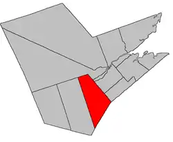 Location within Northumberland County, New Brunswick | |
| Coordinates: 46°36′N 65°44′W | |
| Country | |
| Province | |
| County | Northumberland |
| Erected | 1830 |
| Area | |
| • Land | 824.02 km2 (318.16 sq mi) |
| Population (2016)[1] | |
| • Total | 2,028 |
| • Density | 2.5/km2 (6/sq mi) |
| • Change 2011-2016 | |
| • Dwellings | 974 |
| Time zone | UTC-4 (AST) |
| • Summer (DST) | UTC-3 (ADT) |
For governance purposes it is divided between the village of Blackville and the local service districts of Renous-Quarryville and the parish of Blackville,[3] all of which are members of the Greater Miramichi Regional Service Commission (GMRSC).[4]
Origin of name
The parish was probably named in honour of Hon. William Black, Administrator of the province at the time of its erection.[5]
History
Blackville was erected in 1830 from Ludlow Parish.[6] At the time it extended into modern Kent County, taking in much of Harcourt and Huskisson Parishes.[7]
In 1845 the Kent County line was extended to Sunbury County, transferring the southern part of Blackville to Kent County.[8]
Delineation
Blackville Parish is defined in the Territorial Division Act[2] as being bounded:
- Southeast by the County line; west by Blissfield Parish; north by Southesk Parish; and east by a line running south twenty-two degrees east; and north twenty-two degrees west from the mouth of Renous River.
Communities
Parish population total does not include incorporated municipalities (in bold):
|
|
Demographics
Population
|
LanguageMother tongue (2016)[1]
|
See also
References
- "Census Profile, 2016 Census: Blackville, Parish [Census subdivision], New Brunswick". Statistics Canada. Retrieved September 25, 2019.
- "Chapter T-3 Territorial Division Act". Government of New Brunswick. Retrieved 13 November 2020.
- "New Brunswick Regulation 84-168 under the Municipalities Act (O.C. 84-582)". Government of New Brunswick. Retrieved 19 July 2020.
- "Communities in each of the 12 Regional Service Commissions (RSC) / Les communautés dans chacune des 12 Commissions de services régionaux (CSR)" (PDF), Government of New Brunswick, July 2017, retrieved 2 February 2021
- Ganong, William F. (1896). A Monograph of the Place-Nomenclature of the Province of New Brunswick. Royal Society of Canada. p. 221.
- "10 & 11 Geo. IV c. 15 An Act to alter the Boundary Lines of certain Parishes in the County of Northumberland, and to erect two new Parishes in said County.". Acts of the General Assembly of His Majesty's Province of New Brunswick, Passed in the Year 1830. Fredericton: Government of New Brunswick. 1830. pp. 17–18.
- Ganong, William F. (1901). A Monograph of the Evolution of the Boundaries of the Province of New Brunswick. Royal Society of Canada. p. Map No. 39.
- "8 Vic. c. 80 An Act to extend the Division Line between the Counties of Northumberland and Kent to the rear Line of the Counties of Queen's County and Sunbury.". Acts of the General Assembly of Her Majesty's Province of New Brunswick, Passed in the Year 1845. Fredericton: Government of New Brunswick. 1845. p. 58.
- Statistics Canada: 1996, 2001, 2006 census
- 2011 Statistics Canada Census Profile: Blackville Parish, New Brunswick
Places adjacent to Blackville Parish, New Brunswick | |
|---|---|
| Subdivisions | |
|---|---|
| Cities | |
| Counties | |
| |
