Harcourt Parish, New Brunswick
Harcourt is a civil parish in Kent County, New Brunswick, Canada.[2]
Harcourt | |
|---|---|
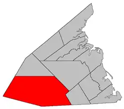 Location within Kent County, New Brunswick. | |
| Coordinates: 46.47°N 65.25°W | |
| Country | |
| Province | |
| County | Kent County |
| Erected | 1827 |
| Area | |
| • Land | 1,170.96 km2 (452.11 sq mi) |
| Population (2016)[1] | |
| • Total | 346 |
| • Density | 0.3/km2 (0.8/sq mi) |
| • Change 2011-2016 | |
| • Dwellings | 274 |
| Time zone | UTC-4 (AST) |
| • Summer (DST) | UTC-3 (ADT) |
For governance purposes it forms part of the local service district of the parish of Harcourt, which also includes Huskisson Parish, reflecting the past inclusion of Huskisson Parish for statistical purposes. The LSD is a member of the Kent Regional Service Commission (KRSC).[3]
Origin of name
The parish was probably named for Earl Harcourt, a Field Marshal of the British Army at the time of its erection.[4]
History
Harcourt was erected from unassigned territory south of the Richibucto River in 1827,[5] comprising a much shallower parish than today.
In 1845 Kent County annexed all of Northumberland County behind it. The wording of existing legislation implicitly adds the annexed area to Harcourt.[6]
In 1850 the northern boundary was explicitly set, removing territory north of the North Forks of the Richibucto River.[7]
In 1883 part of Harcourt east of the railway was added to Sainte-Marie Parish.[8]
Delineation
Harcourt Parish is defined in the Territorial Division Act[2] as being bounded:
- South and west by the County lines; east by Saint Paul Parish and Weldford Parish; and north by a true east and west line passing through the mouth of Jimmy Graham Forks[lower-alpha 1] of the Richibucto River.
Communities
|
|
|
Demographics
Population
|
LanguageMother tongue (2016)[1]
|
See also
Notes
- Now officially named Jimmy Graham Fork.
References
- "Census Profile, 2016 Census: Harcourt, Parish [Census subdivision], New Brunswick". Statistics Canada. Retrieved September 15, 2019.
- "Chapter T-3 Territorial Division Act". Government of New Brunswick. Retrieved 13 November 2020.
- "Communities in each of the 12 Regional Service Commissions (RSC) / Les communautés dans chacune des 12 Commissions de services régionaux (CSR)" (PDF), Government of New Brunswick, July 2017, retrieved 2 February 2021
- Ganong, William F. (1896). A Monograph of the Place-Nomenclature of the Province of New Brunswick. Royal Society of Canada. p. 239.
- "7 Geo. IV c. 31 An Act for the division of the County of Northumberland into three Counties, and to provide for the Government and Representation of the two new Counties.". Acts of the General Assembly of His Majesty's Province of New-Brunswick, Passed in the Year 1827. Fredericton: Government of New Brunswick. 1827. pp. 97–103.
- "8 Vic. c. 80 An Act to extend the Division Line between the Counties of Northumberland and Kent to the rear Line of the Counties of Queen's County and Sunbury.". Acts of the General Assembly of Her Majesty's Province of New Brunswick, Passed in the Year 1845. Fredericton: Government of New Brunswick. 1845. p. 58.
- "13 Vic. c. 51 An Act to consolidate all the Laws now in force for the division of the Province into Counties, Towns and Parishes.". Acts of the General Assembly of Her Mjaesty's Province of New Brunswick, Passed in the Year 1850. Fredericton: Government of New Brunswick. 1850. pp. 142–152, 145–149. Book was poorly proofread, resulting in title typo and reuse of page numbers 145–152.
- "46 Vic. c. 66 An Act to alter the Parish Line between the Parishes of Saint Marys and Harcourt, in the County of Kent.". Acts of the General Assembly of Her Majesty's Province of New Brunswick. Passed in the Month of May 1883. Fredericton: Government of New Brunswick. 1883. p. 182.
- Statistics Canada: 1996, 2001, 2006 census
- 2011 Statistics Canada Census Profile: Harcourt Parish, New Brunswick
Places adjacent to Harcourt Parish, New Brunswick | |
|---|---|
| Subdivisions | |
|---|---|
| Cities | |
| Counties | |
| |