Blanquefort-sur-Briolance
Blanquefort-sur-Briolance is a commune in the Lot-et-Garonne department in southwestern France.
Blanquefort-sur-Briolance | |
|---|---|
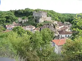 A general view of Blanquefort-sur-Briolance | |
Location of Blanquefort-sur-Briolance 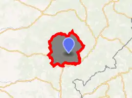
| |
 Blanquefort-sur-Briolance  Blanquefort-sur-Briolance | |
| Coordinates: 44°36′N 0°58′E | |
| Country | France |
| Region | Nouvelle-Aquitaine |
| Department | Lot-et-Garonne |
| Arrondissement | Villeneuve-sur-Lot |
| Canton | Le Fumélois |
| Government | |
| • Mayor (2008–2014) | Pierre Mesqui |
| Area 1 | 41.93 km2 (16.19 sq mi) |
| Population (2017-01-01)[1] | 470 |
| • Density | 11/km2 (29/sq mi) |
| Time zone | UTC+01:00 (CET) |
| • Summer (DST) | UTC+02:00 (CEST) |
| INSEE/Postal code | 47029 /47500 |
| Elevation | 104–274 m (341–899 ft) (avg. 200 m or 660 ft) |
| 1 French Land Register data, which excludes lakes, ponds, glaciers > 1 km2 (0.386 sq mi or 247 acres) and river estuaries. | |
Population
| Year | Pop. | ±% |
|---|---|---|
| 1793 | 1,633 | — |
| 1800 | 1,668 | +2.1% |
| 1806 | 1,781 | +6.8% |
| 1821 | 1,700 | −4.5% |
| 1831 | 1,760 | +3.5% |
| 1836 | 1,730 | −1.7% |
| 1841 | 1,752 | +1.3% |
| 1846 | 1,794 | +2.4% |
| 1851 | 1,748 | −2.6% |
| 1856 | 1,764 | +0.9% |
| 1861 | 1,693 | −4.0% |
| 1866 | 1,592 | −6.0% |
| 1872 | 1,408 | −11.6% |
| 1876 | 1,463 | +3.9% |
| 1881 | 1,501 | +2.6% |
| 1886 | 1,510 | +0.6% |
| 1891 | 1,238 | −18.0% |
| 1896 | 1,169 | −5.6% |
| 1901 | 1,120 | −4.2% |
| 1906 | 1,110 | −0.9% |
| 1911 | 962 | −13.3% |
| 1921 | 824 | −14.3% |
| 1926 | 778 | −5.6% |
| 1931 | 748 | −3.9% |
| 1936 | 700 | −6.4% |
| 1946 | 710 | +1.4% |
| 1954 | 703 | −1.0% |
| 1962 | 727 | +3.4% |
| 1968 | 666 | −8.4% |
| 1975 | 587 | −11.9% |
| 1982 | 549 | −6.5% |
| 1990 | 468 | −14.8% |
| 1999 | 492 | +5.1% |
| 2006 | 499 | +1.4% |
| 2009 | 512 | +2.6% |
References
- "Populations légales 2017". INSEE. Retrieved 6 January 2020.
| Wikimedia Commons has media related to Blanquefort-sur-Briolance. |
| Authority control |
|
|---|
This article is issued from Wikipedia. The text is licensed under Creative Commons - Attribution - Sharealike. Additional terms may apply for the media files.