Bourgougnague
Bourgougnague is a commune in the Lot-et-Garonne department in southwestern France.
Bourgougnague | |
|---|---|
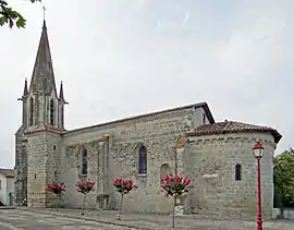 The church in Bourgougnague | |
Location of Bourgougnague 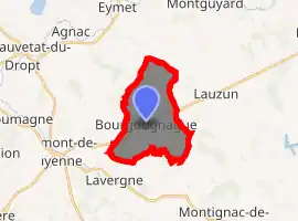
| |
 Bourgougnague  Bourgougnague | |
| Coordinates: 44°37′03″N 0°25′02″E | |
| Country | France |
| Region | Nouvelle-Aquitaine |
| Department | Lot-et-Garonne |
| Arrondissement | Marmande |
| Canton | Le Val du Dropt |
| Intercommunality | Pays de Lauzun |
| Government | |
| • Mayor (2008–2014) | Jean-Marie Constantin |
| Area 1 | 11.73 km2 (4.53 sq mi) |
| Population (2017-01-01)[1] | 321 |
| • Density | 27/km2 (71/sq mi) |
| Time zone | UTC+01:00 (CET) |
| • Summer (DST) | UTC+02:00 (CEST) |
| INSEE/Postal code | 47035 /47410 |
| Elevation | 53–131 m (174–430 ft) (avg. 125 m or 410 ft) |
| 1 French Land Register data, which excludes lakes, ponds, glaciers > 1 km2 (0.386 sq mi or 247 acres) and river estuaries. | |
Population
| Year | Pop. | ±% |
|---|---|---|
| 1800 | 528 | — |
| 1806 | 524 | −0.8% |
| 1821 | 594 | +13.4% |
| 1831 | 628 | +5.7% |
| 1836 | 630 | +0.3% |
| 1841 | 569 | −9.7% |
| 1846 | 576 | +1.2% |
| 1851 | 587 | +1.9% |
| 1856 | 601 | +2.4% |
| 1861 | 564 | −6.2% |
| 1866 | 531 | −5.9% |
| 1872 | 511 | −3.8% |
| 1876 | 486 | −4.9% |
| 1881 | 492 | +1.2% |
| 1886 | 440 | −10.6% |
| 1891 | 405 | −8.0% |
| 1896 | 374 | −7.7% |
| 1901 | 355 | −5.1% |
| 1906 | 357 | +0.6% |
| 1911 | 337 | −5.6% |
| 1921 | 314 | −6.8% |
| 1926 | 348 | +10.8% |
| 1931 | 364 | +4.6% |
| 1936 | 364 | +0.0% |
| 1946 | 346 | −4.9% |
| 1954 | 344 | −0.6% |
| 1962 | 302 | −12.2% |
| 1968 | 239 | −20.9% |
| 1975 | 224 | −6.3% |
| 1982 | 254 | +13.4% |
| 1990 | 256 | +0.8% |
| 1999 | 233 | −9.0% |
| 2006 | 271 | +16.3% |
| 2009 | 285 | +5.2% |
History
From the 4th century AD, barbarians swept into the Gallic Empire. In the 5th century, the Germanic peoples and Burgundians settled in the area. The town owes its name to these people: the pronunciation in Germanic gave "Burgundiaca" meaning "field of the Burgundians."
Sites and Monuments
- The Church of Our Lady of Bourgougnague (Église Notre-Dame de Bourgougnague) from the 13th century. The choir was painted before World War II by the Italian painter Giovanni Masutti, from Stevana in the Treviso region.
- The Church of St. Lawrence (Église de Saint-Laurent).
- Jolibert Castle (Château de Jolibert) which houses the first of the Rural Family Homes (Maison familiale rurale - an association devoted to educate young people) in Europe.
- The manor of the great moor with its chapel dating from the 16th century. This area is a dependency of the Lauzun castle but was also a hunting reserve of King Henry IV.
References
- "Populations légales 2017". INSEE. Retrieved 6 January 2020.
| Wikimedia Commons has media related to Bourgougnague. |
| Authority control |
|---|
This article is issued from Wikipedia. The text is licensed under Creative Commons - Attribution - Sharealike. Additional terms may apply for the media files.