Monflanquin
Monflanquin (Languedocien: Montflanquin) is a commune in the Lot-et-Garonne department in south-western France. Built in 1256 as a military bastide town on a strategic north-south route, it changed hands several times during the Hundred Years' War.
Monflanquin | |
|---|---|
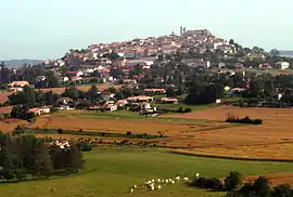 A general view of Monflanquin | |
.svg.png.webp) Coat of arms | |
Location of Monflanquin 
| |
 Monflanquin  Monflanquin | |
| Coordinates: 44°31′59″N 0°46′07″E | |
| Country | France |
| Region | Nouvelle-Aquitaine |
| Department | Lot-et-Garonne |
| Arrondissement | Villeneuve-sur-Lot |
| Canton | Le Haut agenais Périgord |
| Intercommunality | Bastides en Haut-Agenais Périgord |
| Government | |
| • Mayor (2008–2014) | Francis bordes |
| Area 1 | 62.21 km2 (24.02 sq mi) |
| Population (2017-01-01)[1] | 2,313 |
| • Density | 37/km2 (96/sq mi) |
| Time zone | UTC+01:00 (CET) |
| • Summer (DST) | UTC+02:00 (CEST) |
| INSEE/Postal code | 47175 /47150 |
| Elevation | 64–207 m (210–679 ft) (avg. 181 m or 594 ft) |
| 1 French Land Register data, which excludes lakes, ponds, glaciers > 1 km2 (0.386 sq mi or 247 acres) and river estuaries. | |
The village is a member of the Les Plus Beaux Villages de France ("The most beautiful villages of France") association.
Demography
| Year | 1968 | 1975 | 1982 | 1990 | 1999 | 2007 | 2012 | 2017 |
|---|---|---|---|---|---|---|---|---|
| Population | 2354 | 2368 | 2356 | 2431 | 2258 | 2342 | 2345 | 2313 |
| From the year 1962 on: No double counting—residents of multiple communes (e.g. students and military personnel) are counted only once. | ||||||||
References
- "Populations légales 2017". INSEE. Retrieved 6 January 2020.
- Population en historique depuis 1968, INSEE
External links
| Wikimedia Commons has media related to Monflanquin. |
- Monflanquin bastide modèle - Georges Odo
| Authority control |
|---|
This article is issued from Wikipedia. The text is licensed under Creative Commons - Attribution - Sharealike. Additional terms may apply for the media files.