Saint-Maurin
Saint-Maurin is a commune in the Lot-et-Garonne department in south-western France.
Saint-Maurin | |
|---|---|
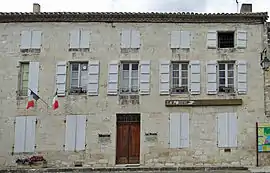 The town hall in Saint-Maurin | |
.svg.png.webp) Coat of arms | |
Location of Saint-Maurin 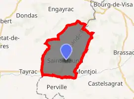
| |
 Saint-Maurin  Saint-Maurin | |
| Coordinates: 44°12′31″N 0°53′36″E | |
| Country | France |
| Region | Nouvelle-Aquitaine |
| Department | Lot-et-Garonne |
| Arrondissement | Agen |
| Canton | Le Pays de Serres |
| Government | |
| • Mayor (2008–2014) | Jean-Philippe Ollier |
| Area 1 | 21.74 km2 (8.39 sq mi) |
| Population (2017-01-01)[1] | 454 |
| • Density | 21/km2 (54/sq mi) |
| Time zone | UTC+01:00 (CET) |
| • Summer (DST) | UTC+02:00 (CEST) |
| INSEE/Postal code | 47260 /47270 |
| Elevation | 72–220 m (236–722 ft) (avg. 102 m or 335 ft) |
| 1 French Land Register data, which excludes lakes, ponds, glaciers > 1 km2 (0.386 sq mi or 247 acres) and river estuaries. | |
The village lies on the road from Agen to Bourg-de-Visa in the valley of the Escornebœuf, a tributary of the Séoune. It is in the arrondissement of Agen and the province of Nouvelle-Aquitaine The population is around 450.
History
St-Maurin, the only village in France of that name, is named after the saint to whom the village's 11th-century abbey is dedicated. The abbey, parts of which still stand beside the village square, was built by Benedictine monks. Reliefs cut into the stone of an archway portray Maurin having the top of his head cut off and his brain spooned out.
The abbey was destroyed by the Albigeois war, then rebuilt. It was again ravaged in the 14th century, this time by troops on the English side in the Hundred Years War. It was again rebuilt in the 15th century but was then attacked once more by Huguenots.
The abbey passed into the ownership of the village in 1645 and was never rebuilt. Many of the walls were demolished as a source of building stone but much of the main arch still stands. The monks' garden exists and so do the stables, now houses. The abbey is now a Monument de France and is being restored.
Beneath and beside the town hall is a museum of artefacts from the village's agricultural past. The village has a school, sports ground, swimming pool and small businesses.
Geography
The Séoune forms the commune's southern border.
References
| Wikimedia Commons has media related to Saint-Maurin. |
- "Populations légales 2017". INSEE. Retrieved 6 January 2020.
| Authority control |
|---|