Villeneuve-sur-Lot
Villeneuve-sur-Lot (French pronunciation: [vilnœv syʁ lɔt]; in the Languedocien dialect of Occitan language: Vilanuèva d'Òlt [bilaˈnwɛβɔ ˈðult]) is a town and commune in the southwestern French department of Lot-et-Garonne. The commune was formerly named Villeneuve-d'Agen.
Villeneuve-sur-Lot | |
|---|---|
Subprefecture and commune | |
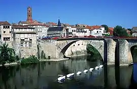 Bridge over the river Lot | |
.svg.png.webp) Coat of arms | |
Location of Villeneuve-sur-Lot 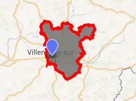
| |
 Villeneuve-sur-Lot  Villeneuve-sur-Lot | |
| Coordinates: 44°24′29″N 0°42′18″E | |
| Country | France |
| Region | Nouvelle-Aquitaine |
| Department | Lot-et-Garonne |
| Arrondissement | Villeneuve-sur-Lot |
| Canton | Villeneuve-sur-Lot-1 and 2 |
| Intercommunality | Villeneuvois |
| Government | |
| • Mayor (2020–2026) | Guillaume Lepers[1] |
| Area 1 | 81.32 km2 (31.40 sq mi) |
| Population (2017-01-01)[2] | 22,064 |
| • Density | 270/km2 (700/sq mi) |
| Time zone | UTC+01:00 (CET) |
| • Summer (DST) | UTC+02:00 (CEST) |
| INSEE/Postal code | 47323 /47300 |
| Elevation | 42–209 m (138–686 ft) (avg. 55 m or 180 ft) |
| 1 French Land Register data, which excludes lakes, ponds, glaciers > 1 km2 (0.386 sq mi or 247 acres) and river estuaries. | |
Villeneuve-sur-Lot is located 22 km northeast of the commune of Agen and straddles the river Lot.
History
Villeneuve was founded in 1254 by Alphonse, Count of Poitiers, brother of Louis IX, on the site of the town of Gajac, which had been deserted during the Albigensian Crusade.[3]
By the early 20th century, Villeneuve-sur-Lot was an important agricultural centre and had a large trade in plums (prunes d'ente); the preparation of preserved plums and the tinning of peas and beans were major industries. The important mill of Gajac stood on the bank of the Lot a little above the town.[4]
Sights
The main quarter of the town is located on the right bank of the Lot River and is linked to the quarter on the left bank by a bridge from the 13th century, the principal arch of which, constructed during the reign of Louis XIII in place of two older arches, has a span of 36 metres (118 ft) and a height of 18 metres (59 ft). On the left bank, portions of the 13th century ramparts, altered and surmounted by machicolations of the 15th century, remain, and high square towers rise above the gates to the north-east and southwest, known respectively as the Porte de Paris and Porte de Pujols.[3]
On the right bank, boulevards have for the most part taken the place of the ramparts. Arcades of the 13th century surround the Place La Fayette, and monumental houses of the 13th, 14th and 15th centuries are to be seen in various parts of the town. The church of St Etienne is late Gothic style. On the left bank of the Lot, 3 km. S.S.W. of Villeneuve, are the 13th-century walls of Pujols located.[3]
The buildings of the formet abbey of Eysses, about 2 km to the N.E., are mainly from the 17th century and serve as a departmental prison and penitentiary settlement. The principal hospital, the hospice St Cyr, is a pretty building standing in beautiful gardens.[3]
The Pont De La Liberation, which spans the Lot river, is a 96.2 metres (316 ft) arch bridge built between 1910 and 1919. When it was completed it was the largest single span concrete arch in the world. It was designed by Eugène Freyssinet, one of the pioneers in using reinforced concrete.
People
Villeneuve-sur-Lot was the birthplace of:
- Mikaël Brageot (born 1987) - Pilot, Red Bull Air Race competitor
- Benoît Broutchoux (1879–1944) - anarchist
- Nicolas Cazalé (born 1977) - actor
- Charles Derennes (1882–1930) - writer, winner of the 1924 edition of the Prix Femina
- Georges Leygues (1857–1933) - politician of the Third Republic
- Caroline von Paulus (born 1959) - more popularly known as Bambou
Twin towns - sister cities
Villeneuve-sur-Lot is twinned with:[5]
 Ávila, Spain
 Bouaké, Ivory Coast
 Neustadt bei Coburg, Germany
 San Donà di Piave, Italy
 Troon, Scotland, United Kingdom
See also
- US Villeneuve, a rugby league club from Villeneuve-sur-Lot
- Rugby Club Villeneuvois
- In Villeneuve-sur-Lot's town hall there is a bust of Marianne by Georges Saupique
References
- "Répertoire national des élus: les maires". data.gouv.fr, Plateforme ouverte des données publiques françaises (in French). 2 December 2020. Retrieved 11 December 2020.
- "Populations légales 2017". INSEE. Retrieved 6 January 2020.
-
 One or more of the preceding sentences incorporates text from a publication now in the public domain: Chisholm, Hugh, ed. (1911). "Villeneuve-sur-Lot". Encyclopædia Britannica. 28 (11th ed.). Cambridge University Press. p. 85.
 - Chisholm 1911.
- "Ma Ville (Menu) => Jumelages". ville-villeneuve-sur-lot.fr (in French). Villeneuve-sur-Lot. Retrieved 2019-11-15.
External links
| Wikimedia Commons has media related to Villeneuve-sur-Lot. |
| Authority control |
|---|
