Botsford Parish, New Brunswick
Botsford is a civil parish in Westmorland County, New Brunswick, Canada.[2]
Botsford | |
|---|---|
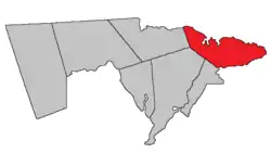 Location within Westmorland County, New Brunswick. | |
| Coordinates: 46.19°N 64.60°W | |
| Country | |
| Province | |
| County | Westmorland County |
| Erected | 1805 |
| Area | |
| • Land | 304.16 km2 (117.44 sq mi) |
| Population (2016)[1] | |
| • Total | 1,058 |
| • Density | 3.5/km2 (9/sq mi) |
| • Change 2011-2016 | |
| • Dwellings | 1,045 |
| Time zone | UTC-4 (AST) |
| • Summer (DST) | UTC-3 (ADT) |
For governance purposes it is divided between the villages of Cap-Pelé and Port Elgin;[3] the incorporated rural community of Beaubassin East;[4] and the local service districts of Bayfield, Cape Tormentine, and the parish of Botsford.[5]
All governance units are members of the Southeast Regional Service Commission.[6]
Origin of name
The parish was named for Amos Botsford, then Speaker of the House of Assembly[7] and MLA for Westmorland County.
History
Botsford was erected in 1805 from unassigned territory east of Sackville and Westmorland Parishes.[8]
In 1850 the western boundary moved west to match that of Westmorland Parish, adding part of Shediac Parish.[9]
In 1894 the western boundary was altered on its northern end, losing area to Shediac Parish;[10] the change was made retroactive to the erection of the parish.
In 1904 the northern of the boundary with Shediac was clarified, possibly altered.[11]
Delineation
Botsford Parish is defined in the Territorial Division Act[2] as being bounded:
- Northeast by Northumberland Strait, south by Baie Verte; west by Westmorland County[lower-alpha 1] and a line running magnetic south by the year eighteen hundred and twenty-four to Cumberland grant line, or its northerly prolongation from the northeast angle of a tract of fourteen hundred acres, granted to Thomas Doiron and others, at the mouth of Tedish River.
Communities
Parish population total does not include incorporated municipalities (in bold).
|
|
|
Demographics
| Year | Pop. | ±% |
|---|---|---|
| 1991 | 1,328 | — |
| 1996 | 1,297 | −2.3% |
| 2001 | 1,216 | −6.2% |
| 2006 | 1,203 | −1.1% |
| 2011 | 1,074 | −10.7% |
| 2016 | 1,058 | −1.5% |
| [12][13][1] | ||
Access routes
Highways and numbered routes that run through the parish, including external routes that start or finish at the parish limits:[14]
|
|
|
|
See also
Notes
- The word County did not occur in the previous Revised Statutes of New Brunswick. What's meant here is Westmorland Parish; the error occurred when the Revised Statutes of New Brunswick were updated in 1973. The boundary actually runs along a prolongation of the Westmorland Parish line until it strikes the boundary between Shediac Parish and Sackville Parish.
References
- "Census Profile, 2016 Census: Botsford, Parish [Census subdivision], New Brunswick". Statistics Canada. Retrieved October 5, 2019.
- "Chapter T-3 Territorial Division Act". Government of New Brunswick. Retrieved 13 November 2020.
- "New Brunswick Regulation 85-6 under the Municipalities Act (O.C. 85-45)". Government of New Brunswick. Retrieved 23 July 2020.
- "New Brunswick Regulation 95-36 under the Municipalities Act (O.C. 95-342)". Government of New Brunswick. Retrieved 23 July 2020.
- "New Brunswick Regulation 84-168 under the Municipalities Act (O.C. 84-582)". Government of New Brunswick. Retrieved 23 July 2020.
- "Communities in each of the 12 Regional Service Commissions (RSC) / Les communautés dans chacune des 12 Commissions de services régionaux (CSR)" (PDF), Government of New Brunswick, July 2017, retrieved 1 February 2021
- Ganong, William F. (1896). A Monograph of the Place-Nomenclature of the Province of New Brunswick. Royal Society of Canada. p. 222.
- "45 Geo. III c. 18 An Act for erecting the Eastern part of the county of Westmorland into a distinct Town or Parish.". Acts of the General Assembly, of His Majesty's Province of New-Brunswick, Passed in the Year 1805. Saint John, New Brunswick: Government of New Brunswick. 1805. pp. 368–369.
- "13 Vic. c. 51 An Act to consolidate all the Laws now in force for the division of the Province into Counties, Towns and Parishes.". Acts of the General Assembly of Her Mjaesty's Province of New Brunswick, Passed in the Year 1850. Fredericton: Government of New Brunswick. 1850. pp. 142–152, 145–149. Book was poorly proofread, resulting in title typo and reuse of page numbers 145–152.
- "57 Vic. c. 36 An Act to amend Chapter 2 of the Consolidated Statutes, of 'The division of the Province into Counties, Towns and Parishes,' so far as relates to the County of Westmorland.". Acts of the General Assembly of Her Majesty's Province of New Brunswick. Passed in the Month of April, 1894. Fredericton: Government of New Brunswick. 1894. pp. 162–163.
- "4 Edward 7 c. 13 An Act in amendment of the Act 59 Victoria, Chapter 8, intituled 'An Act to revise and codify An Act to provide for the division of the Province into Counties, Towns and Parishes.'". Acts of the Legislative Assembly of His Majesty's Province of New Brunswick. Passed in the Month of April, 1904. Fredericton: Government of New Brunswick. 1904. pp. 77–78.
- Statistics Canada: 2001, 2006 census
- 2011 Statistics Canada Census Profile: Botsford Parish, New Brunswick
- Atlantic Canada Back Road Atlas ISBN 978-1-55368-618-7
External links
Places adjacent to Botsford Parish, New Brunswick | |
|---|---|
| Subdivisions | |
|---|---|
| Cities | |
| Counties | |
| |