Sackville Parish, New Brunswick
Sackville is a civil parish in Westmorland County, New Brunswick, Canada.[2]
Sackville | |
|---|---|
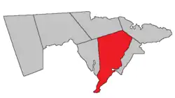 Location within Westmorland County, New Brunswick. | |
| Coordinates: 46.19°N 64.60°W | |
| Country | |
| Province | |
| County | Westmorland County |
| Erected | 1786 |
| Area | |
| • Land | 579.98 km2 (223.93 sq mi) |
| Lowest elevation | 0 m (0 ft) |
| Population (2016)[1] | |
| • Total | 1,182 |
| • Density | 2.0/km2 (5/sq mi) |
| • Change 2011-2016 | |
| • Dwellings | 553 |
| Time zone | UTC-4 (AST) |
| • Summer (DST) | UTC-3 (ADT) |
| Area code(s) | 506 |
For governance purposes it is divided between the village of Sackville, the incorporated rural community of Beaubassin East,[3] and the local service district of the parish of Sackville.[4]
All governance units are members of the Southeast Regional Service Commission.[5]
Origin of name
The parish was named in honour of Lord George Sackville,[6] later Secretary of State for the Colonies.
History
Sackville was established in 1772 as a Nova Scotia township.[7]
Sackville was erected as one of Westmorland County's original parishes in 1786[8] with enlarged boundaries; most of the modern town of Shediac was added.
In 1827 the northern part of Sackville was included in the newly erected Shediac Parish.[9]
In 1880 the boundary with Westmorland Parish was altered, adding a large inland area to Sackville.[10]
In 1894 the existing boundaries were made retroactive to the erection of the parish.[11]
Delineation
Sackville Parish is defined in the Territorial Division Act[2] as being bounded:
- North by the north line of Dorchester Parish prolonged easterly to a point of intersection of the Cumberland grant line, which runs north thirty degrees and thirty minutes west by the magnet of eighteen hundred and sixty seven from the southeast angle of lot number one, granted to Otho Reed, at the mouth of Gaspereau Creek;[lower-alpha 1] west by Dorchester Parish and Chignecto Bay; south and east by Cumberland Basin and the Aulac River, from its mouth to the upper line of the Sackville grant; thence by a line running north by the magnet of the year seventeen hundred and sixty-five to a point on the said line one hundred and two chains southerly from where the road[lower-alpha 2] through Midgic leaves the said line at Edwin Dixon's gate; thence running north fifty-seven degrees and thirty minutes east by the magnet of eighteen hundred and eighty to the channel of Big Jolicure Lake; thence along the said channel and main brook up stream[lower-alpha 3] to the prolongation southwestwardly of the southeast line of David Wheaton's mill lot; thence along the said prolongation and line to the east angle of said Wheaton's mill lot; thence north forty-five degrees east to the Botsford Parish line; northeast by Botsford Parish.
Communities
Parish population total does not include incorporated municipalities (in bold):
|
|
|
Demographics
Population
|
LanguageMother tongue (2016)[1]
| |||||||||||||||||||||||||||||||||||||||
Access routes
Highways and numbered routes that run through the parish, including external routes that start or finish at the parish limits:[15]
|
|
|
|
See also
Notes
- Now officially Gaspereau River.[12]
- Goose Lake Road
- Along Goose Creek and Robinson Brook
References
- "Census Profile, 2016 Census: Sackville, Parish [Census subdivision], New Brunswick". Statistics Canada. Retrieved October 5, 2019.
- "Chapter T-3 Territorial Division Act". Government of New Brunswick. Retrieved 13 November 2020.
- "New Brunswick Regulation 95-36 under the Municipalities Act (O.C. 95-342)". Government of New Brunswick. Retrieved 23 July 2020.
- "New Brunswick Regulation 84-168 under the Municipalities Act (O.C. 84-582)". Government of New Brunswick. Retrieved 23 July 2020.
- "Communities in each of the 12 Regional Service Commissions (RSC) / Les communautés dans chacune des 12 Commissions de services régionaux (CSR)" (PDF), Government of New Brunswick, July 2017, retrieved 1 February 2021
- Ganong, William F. (1896). A Monograph of the Place-Nomenclature of the Province of New Brunswick. Royal Society of Canada. p. 266.
- Ganong, William F. (1899). A Monograph of Historic Sites in the Province of New Brunswick. Royal Society of Canada. p. 335.
- "26 Geo. III Chapter I. An Act for the better ascertaining and confirming the Boundaries of the several Counties within this Province, and for subdividing them into Towns or Parishes.". Acts of the General Assembly of His Majesty's Province of New-Brunswick, passed in the year 1786. Saint John, New Brunswick: Government of New Brunswick. 1786. pp. 3–12.
- "8 Geo. IV c. 13 An Act to erect the North-eastern part of the County of Westmoreland into a distinct Town or Parish, and also to authorize the appointment of Parish Officers at the November General Sessions in each year.". Acts of the General Assembly of His Majesty's Province of New-Brunswick, Passed in the Year 1827. Fredericton: Government of New Brunswick. 1827. pp. 28–30.
- "43 Vic. c. 40 An Act to alter a portion of the Boundary Line of the Parish of Sackville, Westmorland County.". Acts of the General Assembly of Her Majesty's Province of New Brunswick. Passed in the Months of March & April 1880. Fredericton: Government of New Brunswick. 1880. pp. 80–81.
- "57 Vic. c. 36 An Act to amend Chapter 2 of the Consolidated Statutes, of 'The division of the Province into Counties, Towns and Parishes,' so far as relates to the County of Westmorland.". Acts of the General Assembly of Her Majesty's Province of New Brunswick. Passed in the Month of April, 1894. Fredericton: Government of New Brunswick. 1894. pp. 162–163.
- "Gaspereau River". Canadian Geographical Names. Natural Resources Canada. Retrieved 24 August 2016.
- Statistics Canada: 2001, 2006 census
- 2011 Statistics Canada Census Profile: Sackville Parish, New Brunswick
- Atlantic Canada Back Road Atlas ISBN 978-1-55368-618-7
External links
Places adjacent to Sackville Parish, New Brunswick | |
|---|---|
| Subdivisions | |
|---|---|
| Cities | |
| Counties | |
| |